

Between the 1865 and 1880s, a number of stone bridges and culverts were constructed in South Canterbury. Most were small single span structures built of local limestone or bluestone (basalt). Early newspaper reports of the Levels Road Board meetings contained references to a ‘manuka bridge’ at Totara Flat. In 1874, Mr W Williamson, Engineer to the Board, suggested that it might be better to discontinue having anything further to do with bush bridges and recommended the use of stone as a material for bridge works where it could be easily procured. The Levels Road Board called for tenders to construct two stone bridges, one being for the Totara Valley Limestone Bridge, in November 1874. Messrs McGill and Brehaut’s tender of £362.10s was accepted. The remains of a ‘Manuka bridge’ were removed from the Sterndale Valley Road in early 1875, by which time there was already one stone bridge completed.
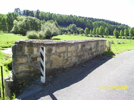
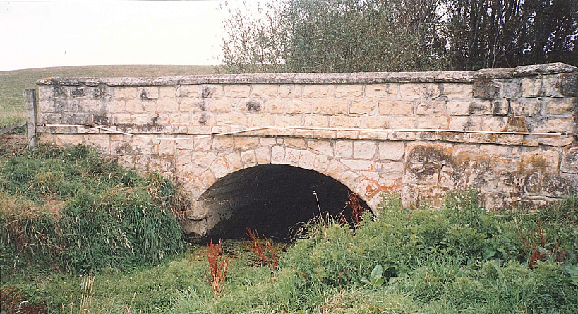
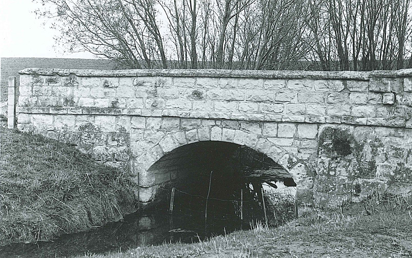
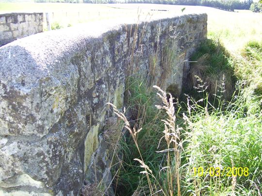
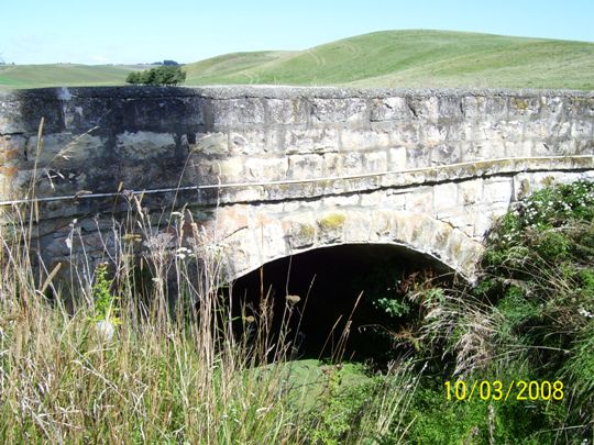
The Totara Valley Limestone Bridge sits over a creek on Sterndale Valley Road. The Stone Bridge has a span of approximately 3.8 metres. The width is 5.5 metres and the depth of the crown of the arch to creek is approximately 2 metres. In his 1958 publication, South Canterbury – A Record of Settlement, Oliver A Gillespie records the construction of these early bridges as follows: ‘Before building a stone bridge, a wooden framework was erected to support the weight as the prepared stones were placed in position. Cement was used only for foundations and to smooth over interstices between the stones after these had been filled with chips. Stones, shaped at an angle to give an arch, were packed as tightly as possible. Those last to be placed in position were the wedge-shaped keystones which locked the whole structure and gave it strength. Once they were placed, the framework was removed and the bridge was ready to take the weight of traffic.’
List Entry Information
Status
Listed
List Entry Status
Historic Place Category 2
Access
Able to Visit
List Number
2010
Date Entered
23rd June 1983
Date of Effect
23rd June 1983
City/District Council
Timaru District
Region
Canterbury Region
Extent of List Entry
Extent includes part of the land described as Legal Road, Canterbury Land District and the structure known as Totara Valley Limestone Bridge thereon. Refer to the extent map tabled at the Rārangi Kōrero Committee meeting on 1 February 2018
Legal description
Legal Road, Canterbury Land District
Status
Listed
List Entry Status
Historic Place Category 2
Access
Able to Visit
List Number
2010
Date Entered
23rd June 1983
Date of Effect
23rd June 1983
City/District Council
Timaru District
Region
Canterbury Region
Extent of List Entry
Extent includes part of the land described as Legal Road, Canterbury Land District and the structure known as Totara Valley Limestone Bridge thereon. Refer to the extent map tabled at the Rārangi Kōrero Committee meeting on 1 February 2018
Legal description
Legal Road, Canterbury Land District
Construction Professional
Name
McGill and Brehaut for Levels Road Board
Type
Builder
Biography
No biography is currently available for this construction professional
Construction Details
Start Year
1874
Type
Original Construction
Construction Materials
Limestone.
Construction Professional
Name
McGill and Brehaut for Levels Road Board
Type
Builder
Biography
No biography is currently available for this construction professional
Construction Details
Start Year
1874
Type
Original Construction
Construction Materials
Limestone.
Historical and Associated Iwi / Hapū / Whānau
Completion Date
4th December 2017
Report Written By
Robyn Burgess
Information Sources
Stone Bridges of South Canterbury
Fougere, J R, Stone Bridges of South Canterbury, Timaru, 1993 (unpublished).
South Canterbury: A record of settlement, 1958
Gillespie, Oliver A, South Canterbury: A record of settlement, 1958 (second edition 1971)
Timaru District Built Heritage Inventory: From Mesopotamia to Pareora River
Opus International Consultants, Timaru District Built Heritage Inventory: From Mesopotamia to Pareora River, July 2004
Historic Stone Arch Bridges
Waugh, John, ‘Historic Stone Arch Bridges’, New Zealand Historic Places, No. 47, May 1994, pp. 20-21.
Other Information
This place was identified as significant under previous legislation with different information requirements. It remains significant under the current legislation. There is opportunity under our legislation and policies to add to this information. Further information about this place may be available from the Southern Regional Office of Heritage New Zealand Pouhere Taonga. Please note that entry on the New Zealand Heritage List/Rarangi Korero identifies only the heritage values of the property concerned, and should not be construed as advice on the state of the property, or as a comment of its soundness or safety, including in regard to earthquake risk, safety in the event of fire, or insanitary conditions. A fully referenced upgrade report is available on request from the Southern Regional Office of Heritage New Zealand
Historical and Associated Iwi / Hapū / Whānau
Completion Date
4th December 2017
Report Written By
Robyn Burgess
Information Sources
Stone Bridges of South Canterbury
Fougere, J R, Stone Bridges of South Canterbury, Timaru, 1993 (unpublished).
South Canterbury: A record of settlement, 1958
Gillespie, Oliver A, South Canterbury: A record of settlement, 1958 (second edition 1971)
Timaru District Built Heritage Inventory: From Mesopotamia to Pareora River
Opus International Consultants, Timaru District Built Heritage Inventory: From Mesopotamia to Pareora River, July 2004
Historic Stone Arch Bridges
Waugh, John, ‘Historic Stone Arch Bridges’, New Zealand Historic Places, No. 47, May 1994, pp. 20-21.
Other Information
This place was identified as significant under previous legislation with different information requirements. It remains significant under the current legislation. There is opportunity under our legislation and policies to add to this information. Further information about this place may be available from the Southern Regional Office of Heritage New Zealand Pouhere Taonga. Please note that entry on the New Zealand Heritage List/Rarangi Korero identifies only the heritage values of the property concerned, and should not be construed as advice on the state of the property, or as a comment of its soundness or safety, including in regard to earthquake risk, safety in the event of fire, or insanitary conditions. A fully referenced upgrade report is available on request from the Southern Regional Office of Heritage New Zealand
Current Usages
Uses: Transport
Specific Usage: Bridge/ Viaduct
Former Usages
General Usage: Transport
Specific Usage: Bridge/ Viaduct
Current Usages
Uses: Transport
Specific Usage: Bridge/ Viaduct
Former Usages
General Usage: Transport
Specific Usage: Bridge/ Viaduct
Sign up to hear more
Get the latest heritage news, features and events delivered
straight to your inbox.
