Blackett’s Lighthouse, relocated in November 2010 to the eastern end of Benvenue Avenue, above the Benvenue Cliffs at Caroline Bay in Timaru, was built in 1877-8 to the designs of notable engineer, John Blackett. Timaru’s port has been an important aspect of the area’s development. Initially ships anchored off shore and unloaded cargoes directly onto the beach. In the 1870s steps were taken to create an artificial harbour by building breakwaters which created a deep water area for the wharves while sand was swept north to form the beach at Caroline Bay. A significant feature from the early days of port activity is the lighthouse.
In 1876 John Blackett designed the lighthouse and while the Timaru Harbour Board favoured a stone structure, timber was eventually decided on for financial reasons. Originally erected in Le Cren’s Terrace (later renamed The Terrace), the lighthouse first came into use on 1 July 1878. It was fitted with a kerosene light, replaced by gas in 1890, then by an electric light in 1920. In 1948 a flashing light was installed, guiding ships entering the port until March 1970 when new port lights were erected above Dashing Rocks. After ten years of disuse Blackett’s Lighthouse was moved to a new site at Maori Park in 1980. When it was moved to Maori Park it became the rear lead beacon for a navigational system which had been erected above the Benvenue Cliffs in 1907. In November 2010 the Blackett’s Lighthouse was again moved, this time several hundred metres away, down the street, across the rail track and closer to the sea at a site on the Benvenue Cliffs to make way for a new Caroline Bay Aquatic Centre at Maori Park.
The lighthouse is constructed in timber, clad with narrow kauri weather boards. The division of the two lower sections is indicated by a wide encircling board and then an x-braced timber balcony surrounds the upper section. The octagonal copper-clad lantern atop the structure has a metal handrail around its platform. The sash windows are decorated with pediments. In its present location it sits on a concrete pad.
Blackett’s Lighthouse is one of only a small number of remaining timber lighthouses in New Zealand. It has historical value from its associations with the early development of Timaru Harbour and its close connection with notable marine engineer, John Blackett. As a structure, the lighthouse illustrates the pivotal function lighthouses have played in the history of New Zealand.
In 1876 John Blackett designed the lighthouse and while the Timaru Harbour Board favoured a stone structure, timber was eventually decided on for financial reasons. Originally erected in Le Cren’s Terrace (later renamed The Terrace), the lighthouse first came into use on 1 July 1878. It was fitted with a kerosene light, replaced by gas in 1890, then by an electric light in 1920. In 1948 a flashing light was installed, guiding ships entering the port until March 1970 when new port lights were erected above Dashing Rocks. After ten years of disuse Blackett’s Lighthouse was moved to a new site at Maori Park in 1980. When it was moved to Maori Park it became the rear lead beacon for a navigational system which had been erected above the Benvenue Cliffs in 1907. In November 2010 the Blackett’s Lighthouse was again moved, this time several hundred metres away, down the street, across the rail track and closer to the sea at a site on the Benvenue Cliffs to make way for a new Caroline Bay Aquatic Centre at Maori Park.
The lighthouse is constructed in timber, clad with narrow kauri weather boards. The division of the two lower sections is indicated by a wide encircling board and then an x-braced timber balcony surrounds the upper section. The octagonal copper-clad lantern atop the structure has a metal handrail around its platform. The sash windows are decorated with pediments. In its present location it sits on a concrete pad.
Blackett’s Lighthouse is one of only a small number of remaining timber lighthouses in New Zealand. It has historical value from its associations with the early development of Timaru Harbour and its close connection with notable marine engineer, John Blackett. As a structure, the lighthouse illustrates the pivotal function lighthouses have played in the history of New Zealand.
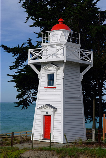
Blackett's Lighthouse, Timaru. Image courtesy of vallance.photography@xtra.co.nz | Francis Vallance | 18/01/2012 | Francis Vallance
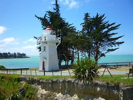
Blackett’s Lighthouse, Timaru. After relocation | Dave Margetts | 10/01/2011 | Heritage New Zealand Pouhere Taonga
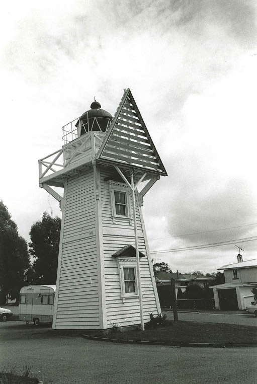
Blackett's Lighthouse, Timaru. Before relocation. Image included in Field Record Form Collection | A E McEwan | 01/03/1989 | Heritage New Zealand Pouhere Taonga
Blackett's Lighthouse, Timaru. Image courtesy of vallance.photography@xtra.co.nz | Francis Vallance | 18/01/2012 | Francis Vallance
Blackett’s Lighthouse, Timaru. After relocation | Dave Margetts | 10/01/2011 | Heritage New Zealand Pouhere Taonga
Blackett's Lighthouse, Timaru. Before relocation. Image included in Field Record Form Collection | A E McEwan | 01/03/1989 | Heritage New Zealand Pouhere Taonga