

Te Rūnanga o Arowhenua, Te Rūnanga o Waihao and Te Rūnanga o Moeraki share an interest in Te Manahuna/Mackenzie District. They are connected to ngā maunga, awa, roto, whenua (mountains, rivers, lakes, land) and to their tūpuna who walked these lands, and who left their mark in the place names, camp sites and tradition of mahinga kai. The mid-nineteenth century ‘Black Maps’ prepared by colonial surveyors show that the Mt Nessing Station homestead area was established on an open stoney flat, east of the Opawa River.
Run No. 164 was taken up by Croft Marsack in 1857. By circa 1860 it was run by George Matson, originally from Mountnessing in Essex, England, who built a small cob house on the large property, being the first Mount (Mt) Nessing Homestead. George died in England in 1863 but his brother, Alfred Kingsford Matson, took over running the property from the mid-1860s. In the 1860s and 1870s Thomas Spencer was also involved as a manager or runholder at Mt Nessing. When Robert Rutherford purchased Mt Nessing Station in 1878 there was already a second, larger, timber structure in front of the cob cottage – this was the second Mt Nessing Homestead, later described as containing a drawing room, hall, dining room, breakfast room, bedrooms, office, kitchen, scullery and dairy. In 1879 Robert was joined in partnership by his brother, Edmund Rutherford. Edmund, and from 1881 his new bride (Margaret, née Speed), moved into the homestead but times were difficult and in 1889 Edmund withdrew from the partnership. In 1891 Robert Rutherford sold Mt Nessing Station to the mortgager and a farm manager ran the farm. In 1899, Edgar Jones purchased the property, by now reduced in size to 5,985 acres. The farming situation had much improved and in the early years of the twentieth century (likely around 1903-1905) Jones added a two-storeyed house in front of, and until the 1950s incorporating, the second dwelling – Jones’ house is the third and only surviving Mt Nessing Station Homestead (List No. 3143).
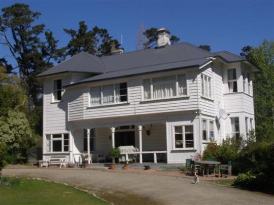
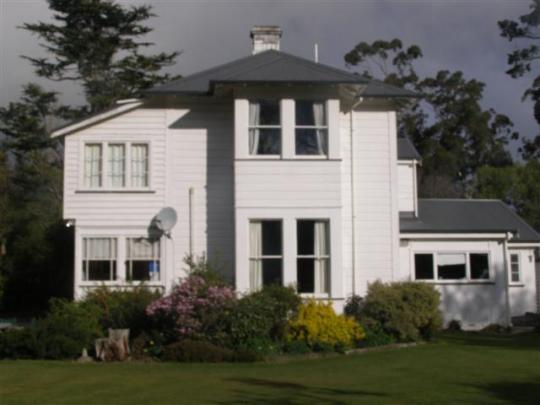
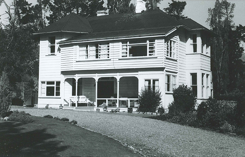
Located in a rural farm setting, up a sweeping drive and set back from the road, the Mt Nessing Homestead is a two-storeyed timber building with a single-storeyed kitchen addition at the south-west corner, in the location where previously the earlier (demolished) timber homestead had adjoined. The exterior cladding largely comprises wide rusticated weatherboarding. The main, north elevation has a verandah with timber posts, above which is a first-floor addition (mid-twentieth century). The projecting north-east corner of the house is polygonal in plan. Most of the windows are sash, including those in the square, two-storeyed bay on the west elevation. The multi-levels of the corrugated metal roof reflect some of the alterations and additions to the house. Two freestanding single-storeyed gabled timber outbuildings stand several metres to the south of the house. As of 2026 these small weatherboard buildings are used for storing wood and other things, but their age and original position are uncertain: one or both may have been one of the small motor sheds or outbuildings marked on a Crown Lease map of 1913.
When first built by Jones in the early twentieth century, the new (third) homestead was connected by a shared stairway to the earlier (second) homestead. In 1913, Jones sold Mt Nessing to the government under the Land Settlement Act. The Station was broken up by way of ballot at that time, thus creating the Mt Nessing district. The Mt Nessing Homestead block of 8,740 acres went to Miss Jessie Guthrie in 1913. Guthrie sold to Bruce Gillies in 1916, who hosted occasional picnics for invalided soldiers from an orthopaedic hospital in Timaru. In 1918 Mt Nessing School was established on land separated from the homestead block (it closed in 1937). James Renton briefly owned the homestead before selling to Mary Simpson in 1920, thus beginning a long and ongoing period of ownership by the Simpson family. The Simpsons have longstanding connections to dog trialling at the property and with the Mt Nessing Golf Club, which was established in 1939 on land leased from the Simpson family and is still grazed. On the death of Mary in 1951, Mt Nessing Station was transferred to her son Donald (Donnie) and his wife Evelyn, who lived in the homestead with their four children. In 1953, the second homestead was demolished. Two bedrooms were added above the verandah during this period, and a room was added to the end of the verandah as a bedroom for Donnie’s sister, Jane (June). After Donnie and Evelyn retired to Nelson, Donald and Jan Simpson took over Mt Nessing Homestead in 1968, and in 1971 a kitchen was added at the west side of the house. After Donald and Jan moved to Christchurch in 1989, Peter and Sonia Simpson bought and moved into Mt Nessing Homestead. James Simpson, and his wife Katie, took over as owners of Mt Nessing Station in 2011. The year 2020 marked 100 years of Mt Nessing Station, and homestead, being in the ownership of the Simpson family. An enclosed room – a later addition – at the north-west corner of the verandah was removed in circa 2025.
List Entry Information
Status
Listed
List Entry Status
Historic Place Category 2
Access
Private/No Public Access
List Number
3143
Date Entered
23rd June 1983
Date of Effect
23rd June 1983
City/District Council
Mackenzie District
Region
Canterbury Region
Extent of List Entry
Extent includes part of the land described as Sec 13 Mt Nessing Settlement (CT CB32F/483), Canterbury Land District and the building known as Mt Nessing Homestead thereon. Refer to the extent map tabled at the Rārangi Kōrero meeting on 8 June 2017.
Legal description
Sec 13 Mt Nessing Settlement (CT CB32F/483), Canterbury Land District
Location Description
Postal Address: 1049 Mt Nessing Road, RD 14, CAVE 7984
Status
Listed
List Entry Status
Historic Place Category 2
Access
Private/No Public Access
List Number
3143
Date Entered
23rd June 1983
Date of Effect
23rd June 1983
City/District Council
Mackenzie District
Region
Canterbury Region
Extent of List Entry
Extent includes part of the land described as Sec 13 Mt Nessing Settlement (CT CB32F/483), Canterbury Land District and the building known as Mt Nessing Homestead thereon. Refer to the extent map tabled at the Rārangi Kōrero meeting on 8 June 2017.
Legal description
Sec 13 Mt Nessing Settlement (CT CB32F/483), Canterbury Land District
Location Description
Postal Address: 1049 Mt Nessing Road, RD 14, CAVE 7984
Construction Details
Type
Original Construction
Description
Current (third) homestead constructed
Period
Early twentieth century (circa 1903-1905)
Type
Demolished - prior building
Description
Rear (earlier/second homestead) part of house removed
Period
1950s
Type
Addition
Description
Bedrooms added above verandah and part of verandah enclosed
Period
1950s
Start Year
2025
startYearCirca
Type
Modification
Description
Enclosure at north-west corner of verandah removed
Construction Details
Type
Original Construction
Description
Current (third) homestead constructed
Period
Early twentieth century (circa 1903-1905)
Type
Demolished - prior building
Description
Rear (earlier/second homestead) part of house removed
Period
1950s
Type
Addition
Description
Bedrooms added above verandah and part of verandah enclosed
Period
1950s
Start Year
2025
startYearCirca
Type
Modification
Description
Enclosure at north-west corner of verandah removed
Historical and Associated Iwi / Hapū / Whānau
Completion Date
8th April 2026
Report Written By
Robyn Burgess
Information Sources
Holm, 1992
J. Holm, Nothing But Grass and Wind: The Rutherfords of Canterbury, Christchurch, 1992 [Hazard Press]
Pinney, 1971
R Pinney, Early South Canterbury Runs, Wellington, 1971
Holm, 1994
Holm, Janet, ‘Enduring Walls’, Historic Places, May 1994, pp. 24-26
Jones, 1933
Jones, Edgar, Autobiography of an Early Settler in New Zealand, 1933 (1996 edition)
Vance, 1965
Vance, William, High Endeavour, 1965
Other Information
This place was identified as significant under previous legislation with different information requirements. It remains significant under the current legislation. A fully referenced copy of the Upgrade Report is available upon request from the Southern Regional Office of Heritage New Zealand Pouhere Taonga. Disclaimer Please note that entry on the New Zealand Heritage List/Rārangi Kōrero identifies only the heritage values of the property concerned, and should not be construed as advice on the state of the property, or as a comment of its soundness or safety, including in regard to earthquake risk, safety in the event of fire, or insanitary conditions. Archaeological sites are protected by the Heritage New Zealand Pouhere Taonga Act 2014, regardless of whether they are entered on the New Zealand Heritage List/Rārangi Kōrero or not. Archaeological sites include ‘places associated with pre-1900 human activity, where there may be evidence relating to the history of New Zealand’. This List entry report should not be read as a statement on whether or not the archaeological provisions of the Act apply to the property(s) concerned. Please contact your local Heritage New Zealand office for archaeological advice.
Historical and Associated Iwi / Hapū / Whānau
Completion Date
8th April 2026
Report Written By
Robyn Burgess
Information Sources
Holm, 1992
J. Holm, Nothing But Grass and Wind: The Rutherfords of Canterbury, Christchurch, 1992 [Hazard Press]
Pinney, 1971
R Pinney, Early South Canterbury Runs, Wellington, 1971
Holm, 1994
Holm, Janet, ‘Enduring Walls’, Historic Places, May 1994, pp. 24-26
Jones, 1933
Jones, Edgar, Autobiography of an Early Settler in New Zealand, 1933 (1996 edition)
Vance, 1965
Vance, William, High Endeavour, 1965
Other Information
This place was identified as significant under previous legislation with different information requirements. It remains significant under the current legislation. A fully referenced copy of the Upgrade Report is available upon request from the Southern Regional Office of Heritage New Zealand Pouhere Taonga. Disclaimer Please note that entry on the New Zealand Heritage List/Rārangi Kōrero identifies only the heritage values of the property concerned, and should not be construed as advice on the state of the property, or as a comment of its soundness or safety, including in regard to earthquake risk, safety in the event of fire, or insanitary conditions. Archaeological sites are protected by the Heritage New Zealand Pouhere Taonga Act 2014, regardless of whether they are entered on the New Zealand Heritage List/Rārangi Kōrero or not. Archaeological sites include ‘places associated with pre-1900 human activity, where there may be evidence relating to the history of New Zealand’. This List entry report should not be read as a statement on whether or not the archaeological provisions of the Act apply to the property(s) concerned. Please contact your local Heritage New Zealand office for archaeological advice.
Current Usages
Uses: Accommodation
Specific Usage: House
Former Usages
General Usage: Accommodation
Specific Usage: House
Current Usages
Uses: Accommodation
Specific Usage: House
Former Usages
General Usage: Accommodation
Specific Usage: House
Sign up to hear more
Get the latest heritage news, features and events delivered
straight to your inbox.
