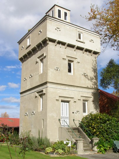
Firth built a country villa on the estate in 1879, to which a concrete tower was added in 1880-1882. Known as 'The Towers', it was erected on the same plot of land where Tamihana is said to have died. During the economic decline of the later 1880s, Firth relinquished the estate to the Bank of New Zealand by way of foreclosure. In 1895 the Assets Realisation Board took control of the land, appointing John McCaw (1849-1930) as manager. McCaw had earlier been assistant superintendent for the New Zealand and Australian Land Company in the South Island, where he had been influenced by the approaches of his superior in the company, Thomas Brydone - a pioneer of scientific farming methods. On his arrival at Matamata, McCaw set about continuing the work that Firth had started by further draining the estate, applying chemical fertiliser and stocking the farm with English Leicester sheep, Hereford cattle and Clydesdale horses. Permanent staff sowed large areas of land in grass and crops, while many Maori workers were additionally contracted for ploughing, harvesting and shearing.
McCaw and his second wife, Frances Buckland (1863-1949) - herself the daughter of a member of the nineteenth-century landed aristocracy in Auckland, Alfred Buckland - moved into Firth's homestead, which subsequently burnt down in June 1902 after a accidental fire. McCaw immediately set about clearing the site and constructing a new house said to have cost £450, which may have been completed within a few months. The new dwelling was built in an almost identical position to the previous structure but was slightly detached from the concrete tower, which had survived the blaze. This positioning may either have been because the tower was believed to have contributed to the conflagration by creating a downdraught, or because such elements were no longer fashionable elements of residential design, or perhaps both. Towers at this time could have been seen as symbolic of wealth and excess at a time when a greater emphasis was being placed on egalitarian ideas in New Zealand society.
Shortly after the building's construction, the estate was divided into 117 farms allocated by ballot in 1904. The breaking up of large landholdings was a popular policy adopted by the first Liberal government in an attempt to allow more people to make a living from the land. John McCaw was himself exempted from the ballot process, being allocated the homestead farm of nearly 400 hectares by the government on the basis of his superior knowledge of farm economics and management. In the first season after the ballot, he was producing twelve cans of milk per day from a hundred cows, while the average supplier produced only two cans from smaller herds.
As the largest homestead in the district and the oldest established farm in the area, the building was a place of social gathering. The Cambridge Hunt met outside its door, and the Premier, Richard Seddon (1845-1906) spent an afternoon there while on a visit to assess the progress of the balloted farms. The McCaws occupied the farm until 1917, having made a few alterations to the building including the creation of an office in a partly-enclosed verandah, which was extended towards the rear of the house. During his occupation of the homestead, McCaw had been chairman of the Matamata Road Board (1895-1905), Piako County Council (1895-1909) and Matamata County Council (1909-1917), as well as having led the St Andrew's Presbyterian Church management committee and Matamata Domain Board. He was also a member of the Auckland Military Service Board during the First World War (1914-1918), while his wife was president of the local Red Cross Committee. Their eldest son Jack was killed at the Front in 1916.
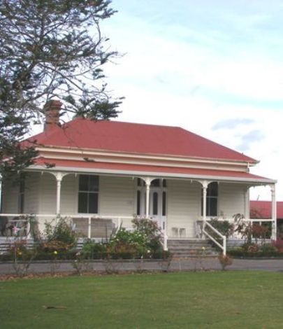
The farm was subsequently purchased by a group of merchants from Wellington and elsewhere, after which the building was occupied by various tenants. The land was further subdivided before being bought by A. W. Vowle, when the farm consisted of just under 100 hectares. In 1972, the homestead site was jointly bought by the Matamata County and Matamata Borough Councils, with the intention of establishing a museum. The homestead and tower were opened for that purpose in November 1978 as the Firth Tower Museum, since when structures from the surrounding area have been introduced to the site and newer buildings erected. Significant changes have been made to the building since its purchase in 1972, including the removal of many internal walls, especially in the central part of the building. The homestead and its displays on early twentieth-century life form a centrepiece of the museum, which is open to the general public on a daily basis.
List Entry Information
Status
Listed
List Entry Status
Historic Place Category 2
Access
Private/No Public Access
List Number
4340
Date Entered
11th December 2003
Date of Effect
11th December 2003
City/District Council
Matamata-Piako District
Region
Waikato Region
Extent of List Entry
Registration includes the structure, its footings and the ground beneath its footprint. It includes all fixtures and finishes. It also incorporates a brick-lined well immediately to the south of the structure and its associated land (see plan in Appendix 4).
Legal description
Lot 1 DP 19768 & Lot 1 DP 40537 (Historic Reserve) (RT SA36A/609), South Auckland Land District
Status
Listed
List Entry Status
Historic Place Category 2
Access
Private/No Public Access
List Number
4340
Date Entered
11th December 2003
Date of Effect
11th December 2003
City/District Council
Matamata-Piako District
Region
Waikato Region
Extent of List Entry
Registration includes the structure, its footings and the ground beneath its footprint. It includes all fixtures and finishes. It also incorporates a brick-lined well immediately to the south of the structure and its associated land (see plan in Appendix 4).
Legal description
Lot 1 DP 19768 & Lot 1 DP 40537 (Historic Reserve) (RT SA36A/609), South Auckland Land District
Why is this place significant?
Cultural Significance
The building has cultural value for its association with the earliest substantial Pakeha settlement in the Matamata area, and for its ongoing use as a local museum.
Historic Significance
Historical Significance or Value The building is historically significant for its connections with the Matamata Estate, the administration of forfeited property, and the development of intensive agriculture in the region during the early twentieth century. It may have archaeological significance as the site of Josiah Firth's estate house, which burnt down in 1902.
Physical Significance
The former McCaw Homestead has aesthetic significance for its external appearance and dramatic setting next to Firth Tower. It is architecturally significant as the earliest homestead believed to survive in the Matamata area.The former McCaw Homestead has aesthetic significance for its external appearance and dramatic setting next to Firth Tower. It is architecturally significant as the earliest homestead believed to survive in the Matamata area.
Why is this place Category 1 / Category 2?
Detail Of Assessed Criteria
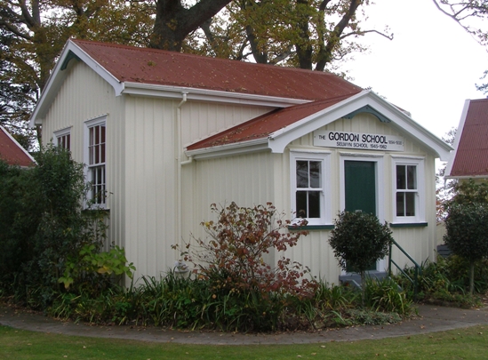
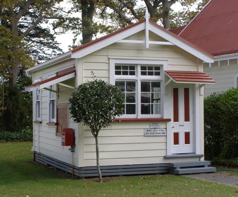
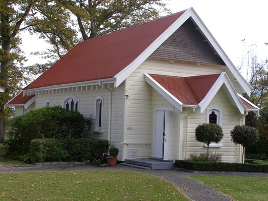
The former McCaw Homestead reflects important and representative aspects of New Zealand history, including the collapse of large estates during the economic depression of the late nineteenth century and their administration by bank-appointed managers until redistribution took place. The building is associated with people of importance in New Zealand history, including Richard Seddon - who introduced the Lands for Settlement Act in 1892 - and John McCaw, an early agricultural pioneer. The place also has associations with the large landholding families in Auckland, through the potential survival of archaeological deposits linked to Josiah Firth's occupation of the estate, and by John McCaw's marriage to the daughter of Alfred Buckland, said to be the largest landowner in Auckland province at one time. The place has the potential to provide knowledge of New Zealand history, both through archaeological means and because of documentary information left by early household members. As a museum and due to the close proximity of other related elements of the historical landscape such as Firth Tower, the place has considerable potential for public education. The building is believed to be the oldest surviving homestead in the Matamata area and is associated with the origins of early Pakeha settlement in this part of the country. It forms part of a wider historical and cultural landscape which includes the death-place of Wiremu Tamihana, the archaeological and structural remains of Firth's homestead, and other elements such as the extensive early planting of exotic trees in the immediate area. The museum itself contains a number of buildings registered by the new Zealand Historic Places Trust/Pouhere Taonga including Firth Tower (#754), although many others have been imported from elsewhere (#4219 Jail Building, #4220 Post Office Building, #4221 Gordon School Building, and #4222 Methodist Church).
Why is this place significant?
Cultural Significance
The building has cultural value for its association with the earliest substantial Pakeha settlement in the Matamata area, and for its ongoing use as a local museum.
Historic Significance
Historical Significance or Value The building is historically significant for its connections with the Matamata Estate, the administration of forfeited property, and the development of intensive agriculture in the region during the early twentieth century. It may have archaeological significance as the site of Josiah Firth's estate house, which burnt down in 1902.
Physical Significance
The former McCaw Homestead has aesthetic significance for its external appearance and dramatic setting next to Firth Tower. It is architecturally significant as the earliest homestead believed to survive in the Matamata area.The former McCaw Homestead has aesthetic significance for its external appearance and dramatic setting next to Firth Tower. It is architecturally significant as the earliest homestead believed to survive in the Matamata area.
Why is this place Category 1 / Category 2?
Detail Of Assessed Criteria
The former McCaw Homestead reflects important and representative aspects of New Zealand history, including the collapse of large estates during the economic depression of the late nineteenth century and their administration by bank-appointed managers until redistribution took place. The building is associated with people of importance in New Zealand history, including Richard Seddon - who introduced the Lands for Settlement Act in 1892 - and John McCaw, an early agricultural pioneer. The place also has associations with the large landholding families in Auckland, through the potential survival of archaeological deposits linked to Josiah Firth's occupation of the estate, and by John McCaw's marriage to the daughter of Alfred Buckland, said to be the largest landowner in Auckland province at one time. The place has the potential to provide knowledge of New Zealand history, both through archaeological means and because of documentary information left by early household members. As a museum and due to the close proximity of other related elements of the historical landscape such as Firth Tower, the place has considerable potential for public education. The building is believed to be the oldest surviving homestead in the Matamata area and is associated with the origins of early Pakeha settlement in this part of the country. It forms part of a wider historical and cultural landscape which includes the death-place of Wiremu Tamihana, the archaeological and structural remains of Firth's homestead, and other elements such as the extensive early planting of exotic trees in the immediate area. The museum itself contains a number of buildings registered by the new Zealand Historic Places Trust/Pouhere Taonga including Firth Tower (#754), although many others have been imported from elsewhere (#4219 Jail Building, #4220 Post Office Building, #4221 Gordon School Building, and #4222 Methodist Church).
Construction Details
Start Year
1879
Type
Other
Description
Site of first homestead ('The Towers')
Start Year
1902
Finish Year
1903
Type
Original Construction
Description
Original construction of McCaw Homestead
Type
Original Construction
Description
Construction of brick-lined well
Period
Early 1900s
Type
Modification
Description
Verandah extended and closed in
Period
pre-1917
Type
Addition
Description
Lean-to added at rear, and porch added to kitchen
Period
post-1917
Start Year
1974
Finish Year
1978
Type
Modification
Description
Modifications, including removal of many internal walls
Construction Materials
Timber frame with weatherboards, brick chimneys and corrugated iron roof.
Construction Details
Start Year
1879
Type
Other
Description
Site of first homestead ('The Towers')
Start Year
1902
Finish Year
1903
Type
Original Construction
Description
Original construction of McCaw Homestead
Type
Original Construction
Description
Construction of brick-lined well
Period
Early 1900s
Type
Modification
Description
Verandah extended and closed in
Period
pre-1917
Type
Addition
Description
Lean-to added at rear, and porch added to kitchen
Period
post-1917
Start Year
1974
Finish Year
1978
Type
Modification
Description
Modifications, including removal of many internal walls
Construction Materials
Timber frame with weatherboards, brick chimneys and corrugated iron roof.
The former McCaw Homestead is located a few kilometres to the east of Matamata, next to a northward bend on Tower Road. The house sits on flat ground on the southern side of the thoroughfare, forming part of the Firth Tower Museum. The structure is set back some distance from the road with a large lawn containing exotic trees occupying the ground in between. The tall and distinctive Firth Tower is positioned immediately to the west of the homestead, while more recent structures lie close to the building's eastern side. There is an open area at the rear, or southern, side of the building containing a brick-lined well. The former McCaw Homestead is a single-storey square-fronted villa, built mostly of timber. It has an open verandah along its northern facade and a partly enclosed verandah on its eastern side. The villa is essentially rectangular in plan, with a wash house and small porch added against its southern and western elevations at a later date. It has a centre-guttered roof, which is covered with corrugated iron, and has overhanging eaves. The timber-framed structure is clad with rusticated weatherboards, which are boxed at the corners. The verandahs are supported with narrow posts bearing capitals and simple fretwork brackets. In spite of these brackets the structure is characterised by a lack of external ornamentation. Its main axis running from front to back also creates an impression from the main frontage that the building is smaller than it actually is, even though it is considerably larger than many houses of its day. This perspective is perhaps enhanced by its position in relation to the earlier Firth Tower, which overshadows the homestead as a reminder of the estate's lofty origins. Internally, the building incorporates a long central passage, with access to a parlour and guest bedroom at the front of the house, and the remnants of a main bedroom and boys' bedroom immediately behind. These formed the more public spaces in the building, with a daughter's room, dining room and toilet originally accessed beyond a dividing door midway down the hall. The kitchen was reached at the end of the hall and in turn led into a maid's room arranged off it on one side. The existence of a spare room for visitors reflects the sociability of a high status rural household, while in contrast, the separation of the servant's quarters to the rear indicates a very different relationship between employer and employee. The use of the rooms until 1917 is known from descriptions provided by a member of the early household Many of the internal spaces have been substantially altered since initial construction including some - such as the maid's room - that have been almost entirely removed. Secondary additions, however, indicate changes to the way that the household was organised over time, such as the provision of a kitchen porch, which may suggest a shift from live-in servants to the employment of outside help. The attached wash house at the rear may similarly indicate washing duties being carried out by the family rather than left for employees to organise. The yard to the rear incorporates a brick-lined well that is believed to have been dug by Robert Williamson, an employee of the Matamata Estate at a similar time to the house. Included within the proposed registered area, it can be considered an integral part of the domestic arrangement and history of the homestead. All of the land immediately beneath and around the building potentially contains archaeological deposits linked to the 1880s Firth Homestead and its destruction in 1902.
Historical and Associated Iwi / Hapū / Whānau
Completion Date
6th September 2004
Report Written By
Martin Jones
Information Sources
Dictionary of New Zealand Biography
Stanley, 1985
Stanley, Joan, Matamata: Growth of a Town, Matamata, 1985
Journal of the Auckland-Waikato Historical Societies
Other Information
A fully referenced version of this report is available from the NZHPT Northern Region Office. Please note that entry on the New Zealand Heritage List/Rarangi Korero identifies only the heritage values of the property concerned, and should not be construed as advice on the state of the property, or as a comment of its soundness or safety, including in regard to earthquake risk, safety in the event of fire, or insanitary conditions.
Historical and Associated Iwi / Hapū / Whānau
Completion Date
6th September 2004
Report Written By
Martin Jones
Information Sources
Dictionary of New Zealand Biography
Stanley, 1985
Stanley, Joan, Matamata: Growth of a Town, Matamata, 1985
Journal of the Auckland-Waikato Historical Societies
Other Information
A fully referenced version of this report is available from the NZHPT Northern Region Office. Please note that entry on the New Zealand Heritage List/Rarangi Korero identifies only the heritage values of the property concerned, and should not be construed as advice on the state of the property, or as a comment of its soundness or safety, including in regard to earthquake risk, safety in the event of fire, or insanitary conditions.
Current Usages
Uses: Civic Facilities
Specific Usage: Museum
Former Usages
General Usage: Accommodation
Specific Usage: House
Web Links
description:
Current Usages
Uses: Civic Facilities
Specific Usage: Museum
Former Usages
General Usage: Accommodation
Specific Usage: House
Web Links
description:
Sign up to hear more
Get the latest heritage news, features and events delivered
straight to your inbox.