

Te Kauaeranga was initially settled by Ngāti Huarere prior to conquest by Marutūahu iwi during the sixteenth century. The flat plains beside Tikapa Moana-o-Hauraki (Firth of Thames) were generally cultivated, with defensive pā established on overlooking ridges. Prior to European arrival, the Thames foreshore was divided into numerous customary interests enabling hapū from throughout Hauraki to access pātiki (flatfish) in associated fishing grounds. The area was known as Tarakonaiti after a large pā situated by the Karaka Stream. After the discovery of gold in 1867, a township and associated industrial activity linked with mining rapidly developed - and the landscape dramatically transformed.
In 1868, Aperahama Te Reiroa and others leased Kauaeranga 14 Block to Auckland entrepreneur Robert Graham. Subsequently forming part of Grahamstown, this included the future Saxon Shaft Pump Station site. Mining at the latter location began in 1871 as part of the Crown Princess Claim operations, which remained active until 1881. In 1883, the Saxon Goldmining Company held the claim for a decade before several further changes in ownership occurred. Incorporating a vertical shaft and poppet head, as well as several industrial buildings, the mine formed one of Thames’ more productive operations. In 1910-12, alterations to the shaft involved its enlargement, re-timbering and subsequent deepening.
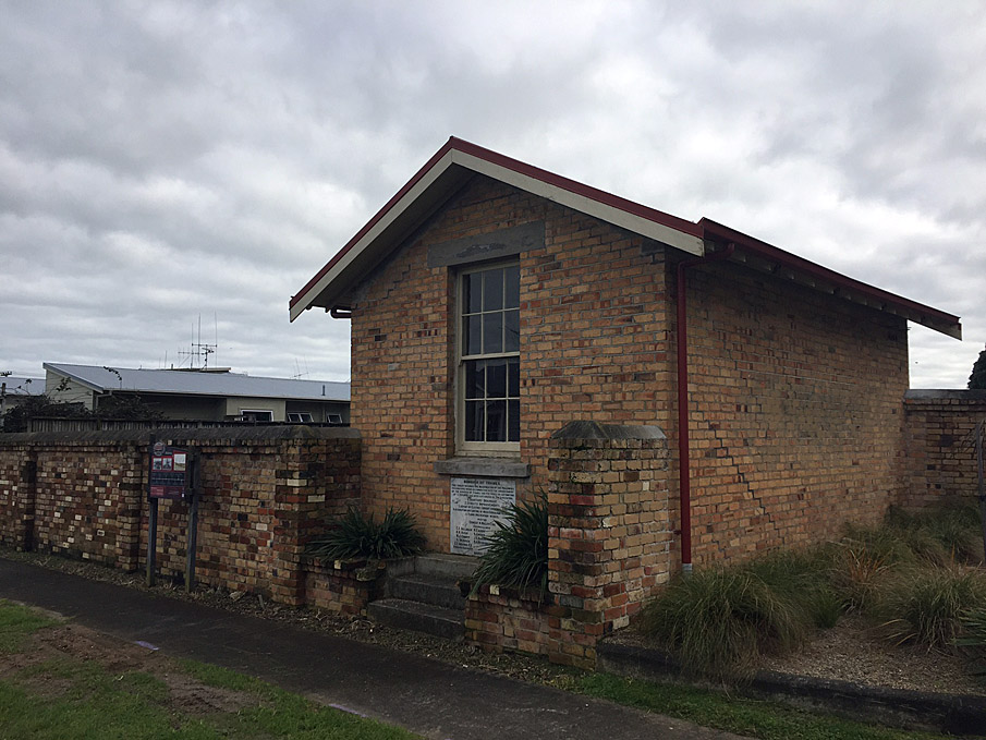
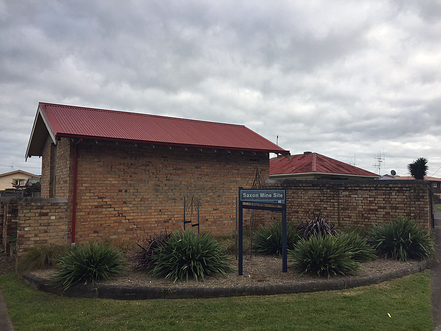
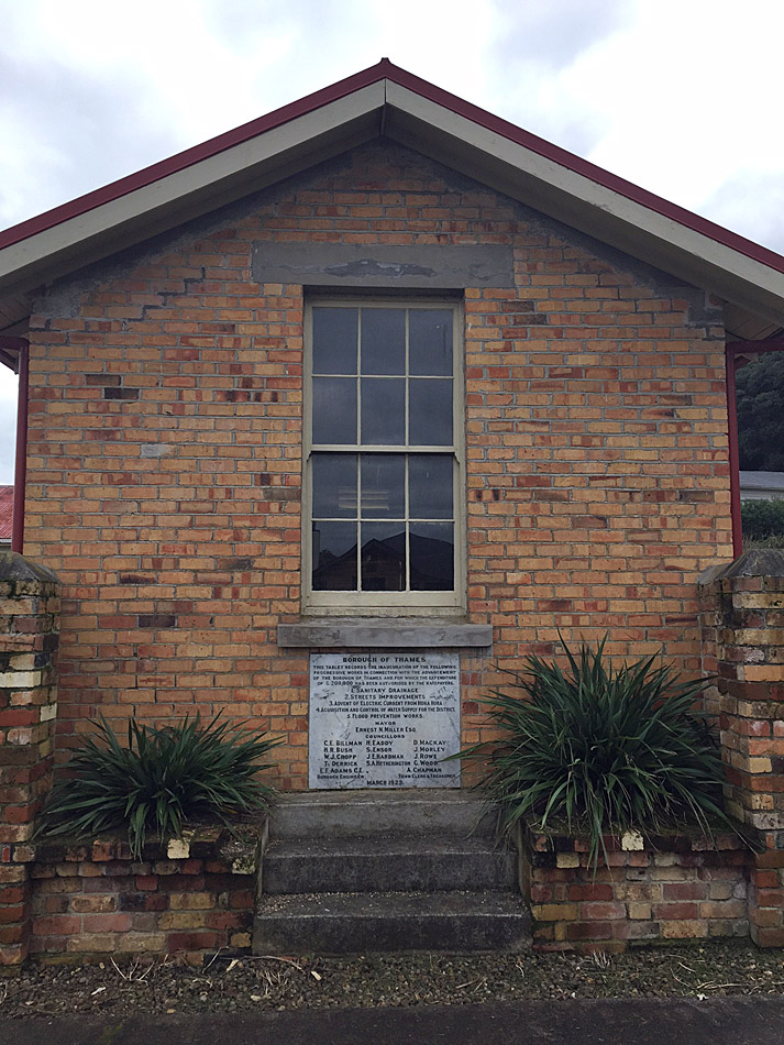
Mining operations at the site ceased in 1914, when the Big Pump at nearby Bella Street was closed and water levels rose in the Thames shafts, effectively putting an end to deep-level mining in the town. Water from extensive underground workings beneath the settlement subsequently spilled out from the Saxon Shaft - the lowest of the mines - flooding vulnerable parts of Thames. Dewatering pumps at the shaft were initially installed in 1917, and four years later a concrete outlet drain, receiving pit and pumphouse footings were constructed by Thames Borough Council land after its purchase of the site. The current brick superstructure was added in 1923 to house electric pumping equipment. The pumphouse’s gabled design was broadly utilitarian, incorporating a door in one side wall and a double-hung sash window facing Albert Street. Although the new facility was seen by some as an opportunity to resume sinking shafts to a shallow level, it formed part of a wider civic infrastructure project that sought to attract and support new enterprise as mining activity declined.
Major works encompassed enhanced water and electricity provision, flood protection and road improvements, as well as a new sewerage scheme inaugurated by the pumping station. These advances were extolled by a large commemorative plaque on the pumphouse exterior, unveiled by the Mayor of Thames, T.W. Rhodes, in a public ceremony involving numerous other dignitaries.
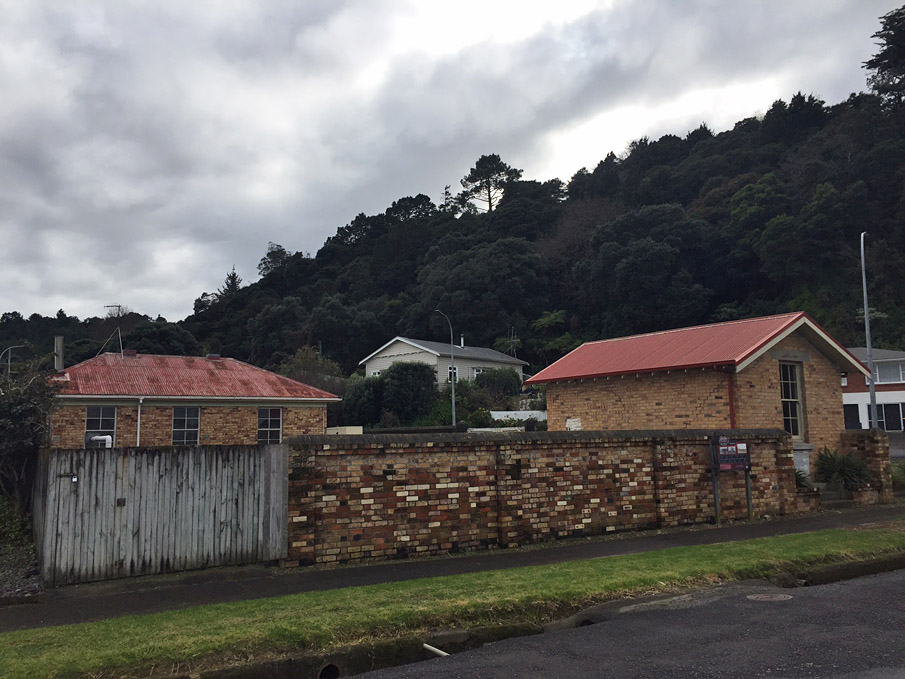
Other buildings subsequently forming part of the station complex included a water treatment building of similar brick construction. A prominent enclosing brick wall with large gates - still surviving - restricted access to the complex, which was reduced in extent by the 1990s. Refurbishment of the pumphouse in 2008-9 included repairing the roof structure and re-cladding with corrugated iron. More than a century after its establishment, the station and its associated complex remain in everyday use for wastewater management.
List Entry Information
Status
Listed
List Entry Status
Historic Place Category 2
Access
Private/No Public Access
List Number
4650
Date Entered
19th March 1986
Date of Effect
19th March 1986
City/District Council
Thames-Coromandel District
Region
Waikato Region
Extent of List Entry
Extent includes the land described as Lot 2 DPS 56936 (RT SA47B/172), South Auckland Land District, and the building and structures known as Saxon Shaft Pump Station thereon.
Legal description
Lot 2 DPS 56936 (RT SA47B/172), South Auckland Land District
Construction Professional
Name
E.F. Adams,
Type
Engineer
Biography
Construction Details
Start Year
1871
Type
Original Construction
Description
Mining shaft
Start Year
1910
Finish Year
1912
Type
Modification
Description
Widening, relining and deepening of shaft
Start Year
1921
Finish Year
1923
Type
Original Construction
Description
Pumphouse building and associated drainage infrastructure
Type
Original Construction
Description
Water treatment building, brick wall and gates
Start Year
2008
Type
Modification
Description
Replacement of corrugated iron cladding on pumphouse roof
Start Year
2009
Type
Modification
Description
Refurbishment of pumphouse
Historical and Associated Iwi / Hapū / Whānau
Completion Date
15th May 2024
Report Written By
Alexandra Foster
Information Sources
Thames Star
Thames Star
Downey, 1992
J.F. Downey, Gold-Mines of the Hauraki District, Christchurch, 1992, pp. 98-9
Other Information
This place was identified as significant under previous legislation with different information requirements. It remains significant under the current legislation. There is opportunity under our legislation and policies to add to this information. Further information about this place may be available from the Northern Regional Office of Heritage New Zealand Pouhere Taonga. A fully referenced copy of the Upgrade Report is available upon request from the Northern Regional Office of Heritage New Zealand Pouhere Taonga Disclaimer Please note that entry on the New Zealand Heritage List/Rarangi Korero identifies only the heritage values of the property concerned, and should not be construed as advice on the state of the property, or as a comment of its soundness or safety, including in regard to earthquake risk, safety in the event of fire, or insanitary conditions. Archaeological sites are protected by the Heritage New Zealand Pouhere Taonga Act 2014, regardless of whether they are entered on the New Zealand Heritage List/Rarangi Korero or not. Archaeological sites include ‘places associated with pre-1900 human activity, where there may be evidence relating to the history of New Zealand’. This List entry report should not be read as a statement on whether or not the archaeological provisions of the Act apply to the property (s) concerned. Please contact your local Heritage New Zealand office for archaeological advice.
Current Usages
Uses: Civic Facilities
Specific Usage: Civic facilities - other
Uses: Commemoration
Specific Usage: Memorial marker/ plaque
Uses: Utilities
Specific Usage: Water Pump House/Pumping Station
Former Usages
General Usage: Mining
Specific Usage: Mine - Shaft
Current Usages
Uses: Civic Facilities
Specific Usage: Civic facilities - other
Uses: Commemoration
Specific Usage: Memorial marker/ plaque
Uses: Utilities
Specific Usage: Water Pump House/Pumping Station
Former Usages
General Usage: Mining
Specific Usage: Mine - Shaft
Sign up to hear more
Get the latest heritage news, features and events delivered
straight to your inbox.
