

Fort Ballance, Wellington's main fortification, was built by the Armed Constabulary, day labourers and prison inmates. Erected on the former site of Te Mahanga Pa the fort was named after the then Minister of Defence, John Ballance [1839-1893]. In the event of war Fort Ballance was to prevent enemy ships entering the inner harbour and provide covering fire for the minefield between Gordon Point and Ward Island. Supported by positions at Kau Point and Point Halswell, when fully armed, Fort Ballance had more guns than any other fort in New Zealand.
Although the Russian attack never eventuated, Fort Ballance was continually upgraded to keep abreast of artillery technology. Yet by 1911 the increased firing range of enemy guns meant that defence of the coast, rather than the inner harbour became the primary concern. Fort Ballance remained operational throughout World War One but Fort Dorset, located in the harbour entrance, became the new bastion of Wellington's coastal defence. In 1924 two of its gun pits were converted into magazines and Fort Ballance was Wellington's main ammunition supply depot until 1959. The fort was briefly rearmed during the Second World War when additional, emergency defences were added.
After the war the site was used for army housing. When the fort was first built, bombproof, wartime accommodation for 40 men had been provided. This proved uncomfortably damp and in 1946 three 40 man huts were rapidly constructed behind the fort. The site was used for accommodation until 1990. Its use as housing saved the fort from being destroyed in the 1960s and 1970s when many of New Zealand's 'unsafe and unsightly' coastal defences were demolished. Fort Ballance is now one of the best, intact examples of that string of fortifications constructed in the 1880s to defend the country from naval attack.
Fort Ballance is a highly significant historical site. Designed and built by the New Zealand Government, it is tangible evidence of New Zealand's first step towards independence from the British Crown. Fort Ballance was the first fort built in Wellington and remained the primary source of the city's protection between 1885 and 1911. As one of New Zealand's best-preserved fortifications from the period of the 'Russian scares' the site has great physical significance. The 1880s layout of the fort is largely unaltered and a good impression of the original nineteenth century fort remains. It is also technologically significant as an early example of the use of concrete as a building material. Fort Ballance is unusual as one of the few military sites in continuous use for 105 years and has immense educational value as a rare illustration of the New Zealand response to the rapid and continuing developments in military technology that characterised the first half of the twentieth century.
List Entry Information
Status
Listed
List Entry Status
Historic Place Category 1
Access
Private/No Public Access
List Number
5074
Date Entered
19th July 1990
Date of Effect
19th July 1990
City/District Council
Wellington City
Region
Wellington Region
Legal description
Sec 89 90 Pt Sec 1-3, SO 32424 etc, Fort Ballance
Location Description
Fort Ballance Road turns off from Shelly Bay Road near the NIWA laboratory at Mahanga Bay. Fort Ballance is located at the end of the road. Note that access to the site is strictly prohibited.
Why is this place significant?
Historic Significance
Historical Significance or Value Fort Ballance and the associated positions on Point Gordon have historical significance resulting from their role in national defence. The coastal defences were built to strengthen the major ports against the threat of Russian expansion in the Pacific. Fort Ballance was the premier fort in the Wellington area for 26 years (1885-1911).
Physical Significance
ARCHITECTURAL QUALITY: Constructed in the 1880s Fort Ballance was prominent in Wellington's coastal defence network and today has the most significant remains of any of the forts built in and around Wellington at this time. Used by the military over a period of 60 years (1885-1945), the 1880s layout of Fort Ballance is largely unaltered and a good impression of the original nineteenth century fort remains. The fort is a permanent reminder of the technology used in the coastal defence network of the 1880s and it is an early example of the use of concrete as a building material. TOWNSCAPE/LANDMARK VALUE: Designed as a coastal defence position, Fort Ballance was and still is camouflaged by earthworks, trees and bushes. It is largely hidden from general view except from above or near at hand.
Construction Professional
Name
Cautley, Henry
Type
Architect
Biography
Henry Cautley served in the Corps of Royal Engineers of the British Army. From 1876 he was an instructor in fortification at the Royal Military College, Woolwich, England. Cautley came to New Zealand in 1883 to advise on coastal defences of the four major ports; Auckland, Wellington, Lyttelton and Port Chalmers. He prepared plans for the fortifications of these ports before leaving New Zealand in 1885. He was posted to Belfast in 1888. He was succeeded as engineer in charge of defence works and harbour fortifications for New Zealand by E.M. Tudor Boddam who had trained at the Royal Military College, Woolwich, and served in the Royal Artillery before being posted to Australia where he was involved with the development of fortifications in Tasmania. While he had no formal training in engineering, Boddam possessed a good knowledge of military engineering and was a diligent and industrious draughtsman. Boddam held this position until 1888 when he returned to Australia.
Construction Details
Start Year
1885
Finish Year
1895
Type
Original Construction
Start Year
1895
Type
Addition
Description
Fort Gordon constructed south of Fort Ballance
Start Year
1921
Finish Year
1922
Type
Modification
Description
Original guns dismounted
Start Year
1924
Type
Modification
Description
Gun pits converted into magazines
Start Year
1941
Type
Addition
Description
Fort Ballance rearmed and emergency defences added
Start Year
1946
Type
Modification
Description
Part of defence wall demolished
Start Year
1946
Type
Addition
Description
Army housing built
Start Year
1990
Type
Modification
Description
All but one house removed from the site
Start Year
1992
Type
Other
Description
Site partially excavated
Construction Materials
Composed of concrete and plastered brick
Notable Features
The majority of the site has been preserved intact. The written instructions preserved on walls of entrance passages and gun emplacements.
DESCRIPTION: In the 1880s there was concern among Empire governments about the threat of Russian expansion into the Pacific, and the implications of this for the defence of those colonies which were more remote from the existing strongholds of British power. In 1880 Col. R.H. Scratchley issued reports assessing the defences of both Australia and New Zealand. He concluded that New Zealand's coastal defences were inadequate and recommended the construction of 'fixed land works' or fortifications at each of the major ports of Auckland, Wellington, Lyttelton, Port Chalmers and Bluff. No immediate action resulted. In 1884 the Governor of New Zealand, Sir William Jervois, again raised the question of coastal defences. Cautley was asked to prepare estimates for the work, and early in 1885 he prepared plans for coastal fortification at Auckland, Wellington, Lyttelton and Port Chalmers. In 1885 he was succeeded by Boddam. The design of the Wellington defences provided for positions at Point Gordon, Point Halswell, Shelly Bay, Mt Crawford, Ngauranga and Kaiwharawhara. The location of Fort Ballance on Point Gordon allowed its armaments to cover the entrance to the channel from extreme range and the inner harbour from close range. The design also included a minefield to be located between Point Gordon and Ward Island in event of war. Electric searchlights were needed to illuminate the channel and the proposed minefield. Supporting gun emplacements were sited nearby at Kau Point and Point Halswell. The fort also mounted an Armstrong disappearing gun as its main armament. This type of gun was standard for all New Zealand forts at that time. Work commenced in 1885 and while the fort became operational later that year, it was not completed until a later date. The armaments were operated by gunners of the Armed Constabulary, redesignated the Permanent Militia in 1886. The demise of the inner harbour defence network occurred as technological developments allowed ship armaments to bombard the ports and the fortifications from greater distances. Fort Ballance was Wellington's premier fort until 1911 when Fort Dorset was built at the entrance to the channel. Fort Ballance was manned during World War 1. It became redundant in 1920 and reverted to a storage area. It was recommissioned in 1940. The armaments were removed in 1945 and since then the site has become an army accommodation area. The remains of the fort were partly buried about 1960 as they were considered to be a danger to children.
DESCRIPTION: In the 1880s there was concern among Empire governments about the threat of Russian expansion into the Pacific, and the implications of this for the defence of those colonies which were more remote from the existing strongholds of British power. In 1880 Col. R.H. Scratchley issued reports assessing the defences of both Australia and New Zealand. He concluded that New Zealand's coastal defences were inadequate and recommended the construction of 'fixed land works' or fortifications at each of the major ports of Auckland, Wellington, Lyttelton, Port Chalmers and Bluff. No immediate action resulted. In 1884 the Governor of New Zealand, Sir William Jervois, again raised the question of coastal defences. Cautley was asked to prepare estimates for the work, and early in 1885 he prepared plans for coastal fortification at Auckland, Wellington, Lyttelton and Port Chalmers. In 1885 he was succeeded by Boddam. The design of the Wellington defences provided for positions at Point Gordon, Point Halswell, Shelly Bay, Mt Crawford, Ngauranga and Kaiwharawhara. The location of Fort Ballance on Point Gordon allowed its armaments to cover the entrance to the channel from extreme range and the inner harbour from close range. The design also included a minefield to be located between Point Gordon and Ward Island in event of war. Electric searchlights were needed to illuminate the channel and the proposed minefield. Supporting gun emplacements were sited nearby at Kau Point and Point Halswell. The fort also mounted an Armstrong disappearing gun as its main armament. This type of gun was standard for all New Zealand forts at that time. Work commenced in 1885 and while the fort became operational later that year, it was not completed until a later date. The armaments were operated by gunners of the Armed Constabulary, redesignated the Permanent Militia in 1886. The demise of the inner harbour defence network occurred as technological developments allowed ship armaments to bombard the ports and the fortifications from greater distances. Fort Ballance was Wellington's premier fort until 1911 when Fort Dorset was built at the entrance to the channel. Fort Ballance was manned during World War 1. It became redundant in 1920 and reverted to a storage area. It was recommissioned in 1940. The armaments were removed in 1945 and since then the site has become an army accommodation area. The remains of the fort were partly buried about 1960 as they were considered to be a danger to children.
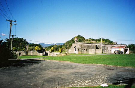
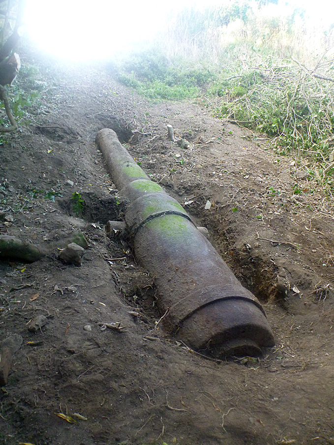
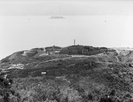
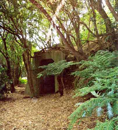
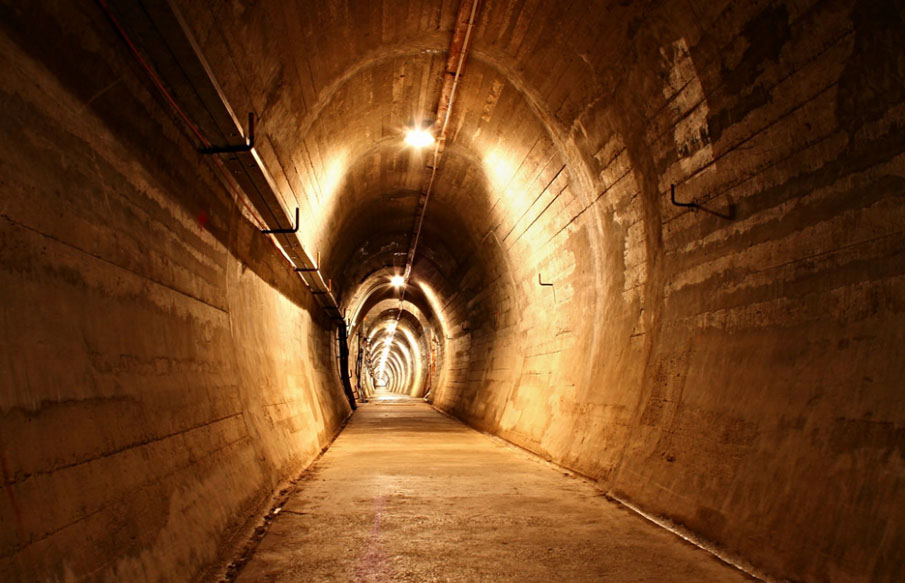
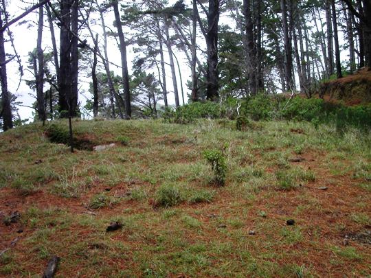
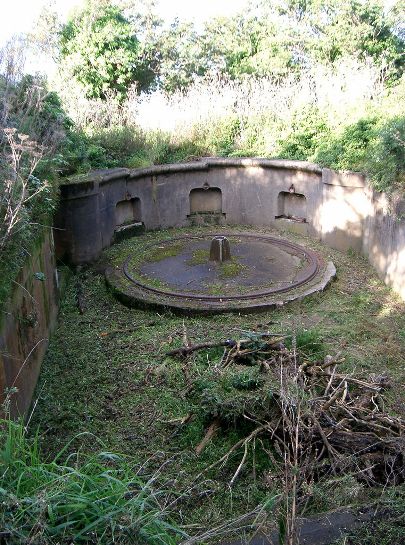
Surrounded by pine trees and covered with undergrowth, from the coastal road there is little hint of the existence of Fort Ballance on Point Gordon's sheer cliff-face. At Mahanga Bay an underwater archaeological survey is being conducted where a jetty, destroyed in 1962, was built in 1886 to enable the Fort's stores to be transported to the site. From here the flattened nature of the ridge on which the fort rests is visible, a common sign that a pa existed on the area. The road leading to the site, re-formed in 1941, was first built in 1888 and a tramway was used to transport goods to the site. The road leads to the rear of the fort, which was originally protected from enemy attack by a slotted, iron lined concrete wall. In 1946 most of the wall was demolished to make way for the army housing that was subsequently removed in 1990. Now an approach from the rear gives a clear view of the original, rectangular barracks which are topped by a concrete battery observation post. This post doubled as a command centre and from 1899 a ten line telephone exchange connected the commander to all batteries in the Wellington area. The sheer circular walls of the five gun pits, arranged in a curved line along the brink of the cliff face were built of concrete over brick, and reinforced with iron bars. The two outermost pits originally housed two six pound Nordenfelt guns. The next two pits date from 1885 and once housed the original seven inch RML guns. Dismounted in 1921-1922, these guns may still be buried on the site. They were replaced by six inch BLHPs, which were also used in the central gun pit. To the left a ladder leads to a second observation post. Well protected from assault, the two pits were converted into magazine areas in 1924 are now bomb-proof, underground rooms. Ammunition was transported from these stores in carts that ran along iron rails still visible in the passageways. Fort Gordon and the Low Battery, both constructed to support the main fortifications are not visible but both remain intact underground. The searchlight emplacements, designed to illuminate the minefield, were demolished in the 1970s as was the six pounder Twin installed in 1942. In 1992 the main gun pits were excavated and left open to the elements. The fort, now surplus to army requirements, is not maintained. The ironwork is rusting and many of the written instructions that covered the walls are no longer legible. It appears that this fortification, built to withstand bomb-blasts, may succumb to the more insidious attack of the Wellington weather. ARCHITECTURAL DESCRIPTION: Fort Ballance is the largest of the military installations located on the spur between Mahanga Bay and Scorching Bay. The other positions were known variously as Fort Gordon, the Spur Battery and the Low or Lower Battery. The ruins of these forts and batteries were partly buried about 1960. Fort Ballance had positions for five main gun pits facing the channel. The concrete gun pits, some of which were closed and others open, are circular or semi-circular and while the guns have been removed the gun emplacements remain intact. The fort follows the topography of the spur and earthworks were used to build up the centre of the position where the command post and communications centre were located. Earthworks also provided protection for the barracks, ablution areas, magazines and stores to the rear of the gun pits. The rear of the fort adjoining the accommodation casemates was enclosed by musketry parapets and loopholed walls, parts of which have been demolished. Fort Gordon, to the south of Fort Ballance, consisted of one gun-pit and magazines. It is now almost completely buried as are the smaller positions lower down the spur. Tunnel entrances have been filled in. Additional firing support was located at Kau Point and Point Halswell, and the positions were protected from land attack by a further defence position on Mount Crawford. MODIFICATIONS: The ruins were partly buried about 1960.
Surrounded by pine trees and covered with undergrowth, from the coastal road there is little hint of the existence of Fort Ballance on Point Gordon's sheer cliff-face. At Mahanga Bay an underwater archaeological survey is being conducted where a jetty, destroyed in 1962, was built in 1886 to enable the Fort's stores to be transported to the site. From here the flattened nature of the ridge on which the fort rests is visible, a common sign that a pa existed on the area. The road leading to the site, re-formed in 1941, was first built in 1888 and a tramway was used to transport goods to the site. The road leads to the rear of the fort, which was originally protected from enemy attack by a slotted, iron lined concrete wall. In 1946 most of the wall was demolished to make way for the army housing that was subsequently removed in 1990. Now an approach from the rear gives a clear view of the original, rectangular barracks which are topped by a concrete battery observation post. This post doubled as a command centre and from 1899 a ten line telephone exchange connected the commander to all batteries in the Wellington area. The sheer circular walls of the five gun pits, arranged in a curved line along the brink of the cliff face were built of concrete over brick, and reinforced with iron bars. The two outermost pits originally housed two six pound Nordenfelt guns. The next two pits date from 1885 and once housed the original seven inch RML guns. Dismounted in 1921-1922, these guns may still be buried on the site. They were replaced by six inch BLHPs, which were also used in the central gun pit. To the left a ladder leads to a second observation post. Well protected from assault, the two pits were converted into magazine areas in 1924 are now bomb-proof, underground rooms. Ammunition was transported from these stores in carts that ran along iron rails still visible in the passageways. Fort Gordon and the Low Battery, both constructed to support the main fortifications are not visible but both remain intact underground. The searchlight emplacements, designed to illuminate the minefield, were demolished in the 1970s as was the six pounder Twin installed in 1942. In 1992 the main gun pits were excavated and left open to the elements. The fort, now surplus to army requirements, is not maintained. The ironwork is rusting and many of the written instructions that covered the walls are no longer legible. It appears that this fortification, built to withstand bomb-blasts, may succumb to the more insidious attack of the Wellington weather. ARCHITECTURAL DESCRIPTION: Fort Ballance is the largest of the military installations located on the spur between Mahanga Bay and Scorching Bay. The other positions were known variously as Fort Gordon, the Spur Battery and the Low or Lower Battery. The ruins of these forts and batteries were partly buried about 1960. Fort Ballance had positions for five main gun pits facing the channel. The concrete gun pits, some of which were closed and others open, are circular or semi-circular and while the guns have been removed the gun emplacements remain intact. The fort follows the topography of the spur and earthworks were used to build up the centre of the position where the command post and communications centre were located. Earthworks also provided protection for the barracks, ablution areas, magazines and stores to the rear of the gun pits. The rear of the fort adjoining the accommodation casemates was enclosed by musketry parapets and loopholed walls, parts of which have been demolished. Fort Gordon, to the south of Fort Ballance, consisted of one gun-pit and magazines. It is now almost completely buried as are the smaller positions lower down the spur. Tunnel entrances have been filled in. Additional firing support was located at Kau Point and Point Halswell, and the positions were protected from land attack by a further defence position on Mount Crawford. MODIFICATIONS: The ruins were partly buried about 1960.
Historical and Associated Iwi / Hapū / Whānau
Completion Date
5th October 2002
Report Written By
Rebecca O'Brien
Information Sources
Appendices to the Journals of the House of Representatives (AJHR)
Appendices to the Journals of the House of Representatives
Alexander Turnbull Library
Alexander Turnbull Library, Wellington
Barrett, 1981
G Barrett, 'Russophobia in New Zealand 1838-1908', Palmerston North, 1981
Cooke, 2000
P. Cooke, Defending New Zealand; Ramparts on the Sea 1840-1950s, Wellington, 2000
Evening Post
Evening Post, 27 Jun 1919, p.7.
McLintock, 1966
An Encyclopedia of New Zealand, Government Printer, Wellington, 1966
New Zealand Mail
New Zealand Mail
Scholefield, 1940
G. H. Scholefield, A Dictionary of New Zealand Biography, Department of Internal Affairs, Wellington, 1940
Wellington City Magazine
Wellington City Magazine
Barber, 1984 (2)
Laurie Barber, Red Coat to Jungle Green; New Zealand's Army in Peace and War, INL Print Ltd, Lower Hutt, 1984
Fraser, 1989
Walter Fraser, Report on Fortifications at Wellington and Fort Ballance in particular, 1989, copy held by NZHPT
Hart, nd
H G Hart, The New Annual Army List and Militia List, London, 1855-1886
Walzl, 1989
Tony Walton, 'Wellington's Defences: A Reconnaissance Survey of the Fortifications of 1884-1945', Department of Conservation, Wellington, 1989
Wicksteed, 1982
M R Wicksteed, The New Zealand Army; A History from the 1840s to the 1980s, Government Printer, Wellington, 1982
Other Information
A fully referenced version of this report is available from the NZHPT Central Region Office. This historic place was registered under the Historic Places Act 1980. This report includes the text from the original Building Classification Committee report considered by the NZHPT Board at the time of registration. Please note that entry on the New Zealand Heritage List/Rarangi Korero identifies only the heritage values of the property concerned, and should not be construed as advice on the state of the property, or as a comment of its soundness or safety, including in regard to earthquake risk, safety in the event of fire, or insanitary conditions.
Location
Related listings
Sign up to hear more
Get the latest heritage news, features and events delivered
straight to your inbox.
