DonateSupporterVisit Heritage
  • Tūrangawaewae
    Places
  • Tira Māori
    Māori Heritage
  • Poutairangahia
    Archaeology
  • Rauemi
    Resources
  • Mō Tātou
    About Us
  • New Zealand Heritage List
  • Nominate and submit
  • Explore the List
  • National Historic Landmarks
  • Plaques
  • Rainbow List Project
  • Lost heritage
  • Visit Heritage
  • Our properties
  • Turnbull House Project
  • Collections
  • Shop
  • Tohu Whenua
  • Tira Māori
  • Conserving Māori heritage
  • Marae built heritage
  • Māori heritage on the List
  • Hinemihi—Te Hokinga Mai
  • What is archaeology?
  • Is there a site on my property?
  • What are my legal requirements?
  • Affecting an archaeological site
  • Declaring an archaeological site
  • Archaeology FAQs
  • Archaeology Digital Library
  • Archaeology guidelines and templates
  • Resources
  • Funding
  • Publications
  • Sustainable management guides
  • Disaster recovery
  • Podcasts & digital resources
  • Education Hub
  • Conservation plans
  • About
  • Board
  • Māori Heritage Council
  • Senior Staff
  • Offices
  • Contact us
  • Careers
  • Covenants
  • Fast-track
  • Corporate documents
  • Currently consulting on
  • Our submissions
  • News
Quick links
Rārangi Kōrero | The List
Explore the List
National Historic Landmarks
Ngā Manawhenua o Aotearoa me ōna Kōrero Tūturu
Quick links
Tapuwae
A Vision for Places of Māori Heritage
Funding for Māori Heritage
Resources
Quick links
Archaeological Authority Portal
Applying for an archaeological authority
Archaeology FAQs
Browse the most frequently asked questions about archaeological authorities and the archaeological process.
Quick links
Quick links
Contact us
Offices
DonateSupporterVisit Heritage
  • Tūrangawaewae
    Places
  • Tira Māori
    Māori Heritage
  • Poutairangahia
    Archaeology
  • Rauemi
    Resources
  • Mō Tātou
    About Us
  • New Zealand Heritage List
  • Nominate and submit
  • Explore the List
  • National Historic Landmarks
  • Plaques
  • Rainbow List Project
  • Lost heritage
  • Visit Heritage
  • Our properties
  • Turnbull House Project
  • Collections
  • Shop
  • Tohu Whenua
  • Tira Māori
  • Conserving Māori heritage
  • Marae built heritage
  • Māori heritage on the List
  • Hinemihi—Te Hokinga Mai
  • What is archaeology?
  • Is there a site on my property?
  • What are my legal requirements?
  • Affecting an archaeological site
  • Declaring an archaeological site
  • Archaeology FAQs
  • Archaeology Digital Library
  • Archaeology guidelines and templates
  • Resources
  • Funding
  • Publications
  • Sustainable management guides
  • Disaster recovery
  • Podcasts & digital resources
  • Education Hub
  • Conservation plans
  • About
  • Board
  • Māori Heritage Council
  • Senior Staff
  • Offices
  • Contact us
  • Careers
  • Covenants
  • Fast-track
  • Corporate documents
  • Currently consulting on
  • Our submissions
  • News
Quick links
Rārangi Kōrero | The List
Explore the List
National Historic Landmarks
Ngā Manawhenua o Aotearoa me ōna Kōrero Tūturu
Quick links
Tapuwae
A Vision for Places of Māori Heritage
Funding for Māori Heritage
Resources
Quick links
Archaeological Authority Portal
Applying for an archaeological authority
Archaeology FAQs
Browse the most frequently asked questions about archaeological authorities and the archaeological process.
Quick links
Quick links
Contact us
Offices
 
Redoubt

RANGITIKEI

Private

Historic Place Category 2

List No. 6232
Quick links:
List GalleryLocationDetails
Constructed in Parewanui in 1868, 'Ross's Redoubt' was hastily erected by settlers to serve as protection during inter-iwi wars, and was later used during the military advance of the Ngati Ruanui military leader Riwha Titokowaru [? - 1888].

The land at Parewanui had been sold to the Crown in 1849 by tangata whenua Ngati Apa. Their right to do so had been strongly disputed by Ngati Raukawa, allies of Te Rauparaha, who claimed control over the area through conquest. Ngati Apa retained a reserve of 647.5 hectares [1600 acres] in Parewanui. By the mid 1850s a number of Wellington farmers, many of whom were Highland Scots of the Presbyterian faith, had settled in the area.

The first Presbyterian service was held in the district in 1852 by Reverend James Duncan [1813-1907], a missionary who had formerly worked among Maori in Turakina. Five years later, land for a Scottish Kirk was donated by Adam Keir, a settler from Edinburgh whose property bordered on the Parewanui reserve. A church was erected in 1862, a year in which tensions escalated between Ngati Apa and Ngati Raukawa over the distribution of money made from illegal rental arrangements with settlers.

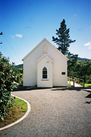
The 'neat and suitable church' at Parewanui was a simple, rectangular building with a steeply pitched roof. Clear lancet windows in the small entrance porch and along the sides of the church allowed light into the building interior. Built entirely of native timbers, two walls of the church include gun flaps similar to those found in early redoubts. The space between the walls is unusually wide, suggesting that the double-skinned walls of the church may have been filled with bulletproof clay or pebbles. These features indicate that this small Scottish Kirk was intended to double as a protection for the settlers in the event of war between Ngati Apa and Ngati Raukawa.

Nepia Taratoa [1793?-1863], the Ngati Raukawa leader responsible for the illegal rental arrangements, died in 1863, shortly after the completion of the church. After Taratoa's death the fierce dispute over the rents intensified and each iwi began preparing for war. Fearing that they would become involved in the conflict, the settlers dragged the fortified church up to Adam Keir's house and surrounded both buildings with an embankment. The complex was named 'Ross's Redoubt'. During the three years in which armed confrontation between the two iwi seemed imminent the settlers developed defensive strategies and strengthened their militia. In late 1866 the Superintendent of the Wellington Province, Dr Isaac Featherston, helped negotiate a peaceful settlement by persuading the parties to sell the disputed land to the Crown.

Just two years later the settlers were again under threat. On 22 November 1868 Major John Marshall was informed by iwi at Putiki that Ngati Ruanui military leader Riwha Titokowaru [? - 1888] had began a military advance from Wanganui towards Foxton. Marshall decided to 'call out part of the Militia for active service, to throw up redoubts and make every preparation for the defence of the district in doing which I have been heartily supported by every man in it'. The settler militia at Parewanui mobilised and work renovating and constructing redoubts began the following morning. The Rangitikei redoubts were typically square in shape. They were protected by a sheer vertical wall made of turf and bracken. A ledge on the sloping inner wall provided the position from which defenders would fire on their attackers. Bastions on the corners of the redoubt were designed to allow defenders to fire on any attackers who came too close to the wall.

By the end of the weeked Ross's Redoubt formed part of a chain of 10 defensive positions designed to protect settlers from Titokowaru's advance. On 22 January 1869 Marshall described the redoubt as 'excellent place of refuge for the inhabitants of that portion of [the] district which is much exposed and to which it would be difficult to send immediate relief in the event of it being required'. Marshall further noted that the 'probable force collecting here would be about Fifty of all ranks'. Initially renovated for £10, £10.5.0 was spent later that year on further improvements and the installation of a drawbridge at the church entrance that provided protection against sudden rushes or night attacks.

When Titokowaru's campaign came to an abrupt and mysterious halt in 1869, the government ordered that all timber and iron used on the construction of blockhouses should be sold. Eight of the ten Rangitikei blockhouses were immediately dismantled. The ninth was demolished a year later. The church, which had served as the blockhouse at Ross's Redoubt, was re-sited on land in Ngati Apa's Parewanui reserve and used by the Presbyterian parish of Bulls. In 2000 it was relocated to serve as a parish hall for St Andrew's Church in Waikanae. Yet the redoubts that had served to protect the blockhouses remained at least partially intact.

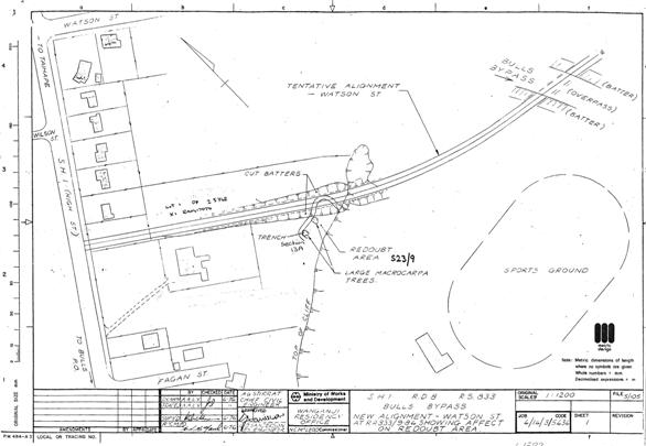
The remains of Ross's Redoubt were first recorded by the New Zealand Archaeological Association in 1974. Aerial photographs from the period showed the remains of the redoubt as a small, roughly square site. The remains of the ditch that had surrounded the redoubt were visible, as were the two corner boxes that flanked the redoubt on opposite corners. Although grassed over, it was in good condition. The redoubt, located amid the farmland of Waitatapia Station, remains discernable today.

The redoubt is archaeologically significant for the insight it gives into the defensive strategies adopted by Pakeha settlers during the 1860s. Constructed to protect Pakeha from inter-iwi warfare over rental agreements, the redoubt also provides insight into the informal (and illegal) settlement practices adopted by Maori and Pakeha both in the Rangitikei region and throughout New Zealand. It highlights the tensions differing ideas regarding the use of land created both among iwi, and between the government and iwi, in the late-nineteenth century. The redoubt is also historically important as one of the best preserved of the redoubt used in Rangitikei by settlers in preparation for Titokowaru's nationally significant but unconsummated military advance towards Foxton.
Redoubt | Heritage New Zealand Pouhere Taonga

List Entry Information

Overview

Status
Listed

List Entry Status
Historic Place Category 2

Access
Private/No Public Access

List Number
6232

Date Entered
23rd September 1986

Date of Effect
23rd September 1986

City/District Council
Rangitīkei District

Region
Horizons (Manawatū-Whanganui) Region

Legal description

Sec 28, Rangitikei district, Blk XIII, Rangitoto SD

Location Description

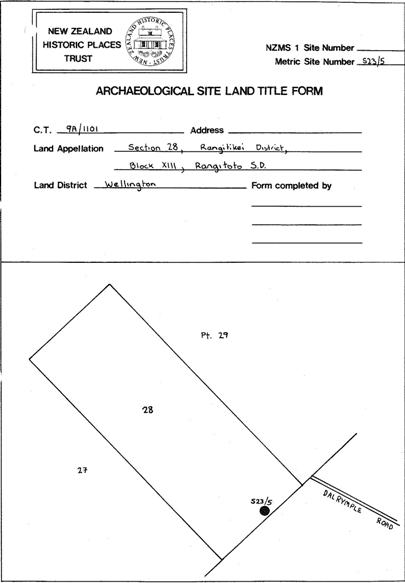
Located south of Waitatapia Station, approximately 275 metres from the end of Dalrymple Road.

Detailed List Entry

Construction Details

Start Year

1866

Type

Original Construction

Start Year

1868

Type

Modification

Description

Redoubt renovated

Start Year

1869

Type

Addition

Description

Drawbridge added

Reference

Historical and Associated Iwi / Hapū / Whānau

Iwi

Ngāti Apa

Public NZAA Number

S23/5

Completion Date

1st July 2004

Report Written By

Rebecca O'Brien

Information Sources

Arapere, 1999

B. Arapere, 'Maku ano hei hanga I toku nei whare; Hapu Dynamics in the Rangitikei Area, 1830-1872', A thesis submitted in partial fulfilment for the requirements for the degree of Master of the Arts in History, The University of Auckland, February, 1999

Dictionary of New Zealand Biography

Dictionary of New Zealand Biography

Journal of the Whanganui Historical Society Inc.

Journal of the Whanganui Historical Society Inc.

Report Written By

This place was identified as significant under previous legislation with different information requirements. It remains significant under the current legislation. There is opportunity under our legislation and policies to add to this information. Further information about this place may be available from the Central Regional Office of Heritage New Zealand Pouhere Taonga. A fully referenced version of this report is available from the Central Region of the New Zealand Historic Places Trust. Please note that entry on the New Zealand Heritage List/Rarangi Korero identifies only the heritage values of the property concerned, and should not be construed as advice on the state of the property, or as a comment of its soundness or safety, including in regard to earthquake risk, safety in the event of fire, or insanitary conditions.

Further Information

Current Usages

Former Usages

General Usage:: Defence

Specific Usage: Redoubt

Themes

Web Links

Overview

Status

Listed

List Entry Status

Historic Place Category 2

Access

Private/No Public Access

List Number

6232

Date Entered

23rd September 1986

Date of Effect

23rd September 1986

City/District Council

Rangitīkei District

Region

Horizons (Manawatū-Whanganui) Region

Legal description

Sec 28, Rangitikei district, Blk XIII, Rangitoto SD

Location Description

Located south of Waitatapia Station, approximately 275 metres from the end of Dalrymple Road.

Status

Listed

List Entry Status

Historic Place Category 2

Access

Private/No Public Access

List Number

6232

Date Entered

23rd September 1986

Date of Effect

23rd September 1986

City/District Council

Rangitīkei District

Region

Horizons (Manawatū-Whanganui) Region

Legal description

Sec 28, Rangitikei district, Blk XIII, Rangitoto SD

Location Description

Located south of Waitatapia Station, approximately 275 metres from the end of Dalrymple Road.

Construction Information

Construction Details

Start Year

1866

Type

Original Construction

Start Year

1868

Type

Modification

Description

Redoubt renovated

Start Year

1869

Type

Addition

Description

Drawbridge added

Construction Details

Start Year

1866

Type

Original Construction

Start Year

1868

Type

Modification

Description

Redoubt renovated

Start Year

1869

Type

Addition

Description

Drawbridge added

Reference

Historical and Associated Iwi / Hapū / Whānau

Iwi: Ngāti Apa

Public NZAA Number

S23/5

Completion Date

1st July 2004

Report Written By

Rebecca O'Brien

Information Sources

Arapere, 1999

B. Arapere, 'Maku ano hei hanga I toku nei whare; Hapu Dynamics in the Rangitikei Area, 1830-1872', A thesis submitted in partial fulfilment for the requirements for the degree of Master of the Arts in History, The University of Auckland, February, 1999

Dictionary of New Zealand Biography

Dictionary of New Zealand Biography

Journal of the Whanganui Historical Society Inc.

Journal of the Whanganui Historical Society Inc.

Other Information

This place was identified as significant under previous legislation with different information requirements. It remains significant under the current legislation. There is opportunity under our legislation and policies to add to this information. Further information about this place may be available from the Central Regional Office of Heritage New Zealand Pouhere Taonga. A fully referenced version of this report is available from the Central Region of the New Zealand Historic Places Trust. Please note that entry on the New Zealand Heritage List/Rarangi Korero identifies only the heritage values of the property concerned, and should not be construed as advice on the state of the property, or as a comment of its soundness or safety, including in regard to earthquake risk, safety in the event of fire, or insanitary conditions.

Historical and Associated Iwi / Hapū / Whānau

Iwi: Ngāti Apa

Public NZAA Number

S23/5

Completion Date

1st July 2004

Report Written By

Rebecca O'Brien

Information Sources

Arapere, 1999

B. Arapere, 'Maku ano hei hanga I toku nei whare; Hapu Dynamics in the Rangitikei Area, 1830-1872', A thesis submitted in partial fulfilment for the requirements for the degree of Master of the Arts in History, The University of Auckland, February, 1999

Dictionary of New Zealand Biography

Dictionary of New Zealand Biography

Journal of the Whanganui Historical Society Inc.

Journal of the Whanganui Historical Society Inc.

Other Information

This place was identified as significant under previous legislation with different information requirements. It remains significant under the current legislation. There is opportunity under our legislation and policies to add to this information. Further information about this place may be available from the Central Regional Office of Heritage New Zealand Pouhere Taonga. A fully referenced version of this report is available from the Central Region of the New Zealand Historic Places Trust. Please note that entry on the New Zealand Heritage List/Rarangi Korero identifies only the heritage values of the property concerned, and should not be construed as advice on the state of the property, or as a comment of its soundness or safety, including in regard to earthquake risk, safety in the event of fire, or insanitary conditions.

Further Information

Former Usages

General Usage: Defence

Specific Usage: Redoubt

Former Usages

General Usage: Defence

Specific Usage: Redoubt

Location

Loading
Related listings
Scottish Kirk, Waikanae
Scottish Kirk
Redoubt
Redoubt
Redoubt
Redoubt
Scottish Kirk, Waikanae
Scottish Kirk
Sign up to hear more

Get the latest heritage news, features and events delivered
straight to your inbox.

Subscribe
  • Places
  • Nominate and submit
  • National Historic Landmarks
  • Places
  • Nominate and submit
  • National Historic Landmarks
  • Tira Māori
  • Conserving Māori heritage
  • Marae built heritage
  • Tira Māori
  • Conserving Māori heritage
  • Marae built heritage
  • Archaeological authorities
  • Archaeology Digital Library
  • Archaeological authorities
  • Archaeology Digital Library
  • All resources
  • Publications
  • Funding
  • All resources
  • Publications
  • Funding
  • FAQs
  • FAQs
Follow us on:
Places
  • Places
  • Nominate and submit
  • National Historic Landmarks
Tira Māori
  • Tira Māori
  • Conserving Māori heritage
  • Marae built heritage
Archaeology
  • Archaeological authorities
  • Archaeology Digital Library
Resources
  • All resources
  • Publications
  • Funding
FAQs
  • FAQs
Follow us on
HomePrivacyTerms and conditionsAbout this site
© Heritage New Zealand Pouhere Taonga 2026.