

List Entry Information
Status
Listed
List Entry Status
Historic Area
Access
Private/No Public Access
List Number
7367
Date Entered
13th December 1996
Date of Effect
13th December 1996
City/District Council
Auckland Council
Region
Auckland Council
Extent of List Entry
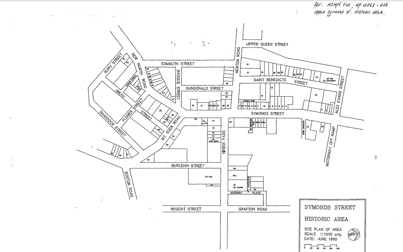
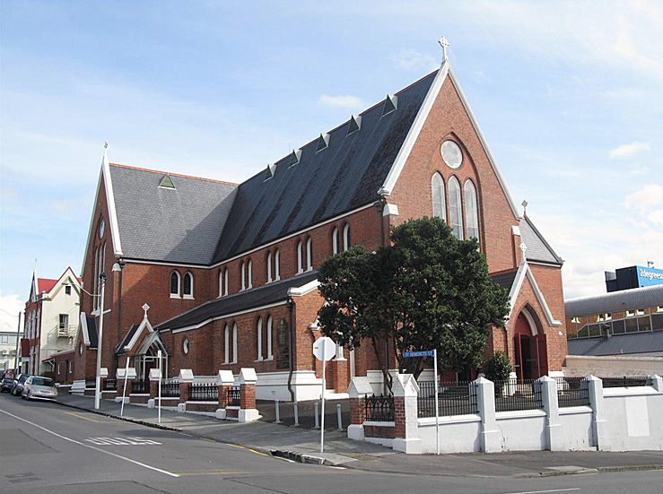
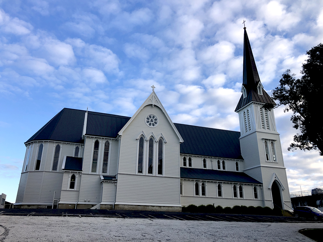
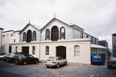
The area extends from the Alex Evans Street and Northern Motorway off-ramp intersection, south to the Symonds Street/New North Road/Mt Eden Road intersection. The historic area also includes 21 New North Road, the entire southern side of the first block of Mt Eden Road (1-27), the former Grafton Library, and Mt Eden Pumping Station, both situated on the northern side of this first block of Mt Eden Road. It also includes 147 Newton Road (Orange Coronation Hall), St David's Church and St Sepulchre Church at 69 and 70 Khyber Pass Road respectively, along with Winstone's Stables bounded by Stable lane and St Benedicts Street. Please refer to the attached map of the Upper Symonds Street Historic Area (in the registration report). A key to the map is supplied which shows the name of each building against its street number. Note: several buildings within this historic area have subsequently been demolished [update January 2016].
Status
Listed
List Entry Status
Historic Area
Access
Private/No Public Access
List Number
7367
Date Entered
13th December 1996
Date of Effect
13th December 1996
City/District Council
Auckland Council
Region
Auckland Council
Extent of List Entry
The area extends from the Alex Evans Street and Northern Motorway off-ramp intersection, south to the Symonds Street/New North Road/Mt Eden Road intersection. The historic area also includes 21 New North Road, the entire southern side of the first block of Mt Eden Road (1-27), the former Grafton Library, and Mt Eden Pumping Station, both situated on the northern side of this first block of Mt Eden Road. It also includes 147 Newton Road (Orange Coronation Hall), St David's Church and St Sepulchre Church at 69 and 70 Khyber Pass Road respectively, along with Winstone's Stables bounded by Stable lane and St Benedicts Street. Please refer to the attached map of the Upper Symonds Street Historic Area (in the registration report). A key to the map is supplied which shows the name of each building against its street number. Note: several buildings within this historic area have subsequently been demolished [update January 2016].
Why is this place significant?
Cultural Significance
This historic area was registered under the Historic Places Act 1993. The following text is from the original Historic Area Assessment Under Section 23 Criteria report considered by the NZHPT Board at the time of registration. Social: The Upper Symonds Street area is very similar in terms of its social history, with that of the Cuba Street Historic Area in Wellington. There seems to be a general paradigm for areas in the major centres such as these where development was significantly enhanced by the introduction of horse drawn and then electric trams around the turn of the century, but significantly declined with the disappearance of the trams and a drop off in the number of people coming into the area as the social and economic infrastructure of the surrounding city changed. The community that was left tended in these circumstances to have a strong local identity but in the sense that it was a small community battling for survival on the outskirts of the central business district. The paradigm in this respect therefore became one where time, and development, stopped before the Second World War, and progressed little further beyond this point. The architecture has remained but in a run down state, while businesses and buildings have suffered the inevitable invasion of take-away bars, video parlours and other fringe retailing activities which tend to detract from the qualities and character of the earlier period.
Historic Significance
Historical Significance or Value This historic area was registered under the Historic Places Act 1993. The following text is from the original Historic Area Assessment Under Section 23 Criteria report considered by the NZHPT Board at the time of registration. Historical: From the evidence presented it is clear that this area was reshaped substantially between the l880s and the 1930s as it evolved from a residential to a retail/commercial servicing centre, Petry and Matthews say little about the people and processes involved, but it is clear that this development was partly shaped by changes to the transport system (just as present road widening proposals threaten one object, the Astor). Although different businesses and people appear to have been associated with these buildings, the area can be said to have had a shared history that may loosely be defined as a move from residential to commercial use late 19th century/early 20th century, followed by a long period of decline. That stagnation and decline has been responsible for preserving much of its earlier streetscape features without large-scale additions of modem buildings or the gentrification of Parnell and Devonport. As such, it may be 'A' typical of inner Auckland city areas. Petry and Matthews have sketched the Upper Symonds Street area's history and cultural use over the last two centuries. While considerably more information would be desirable (especially on the owners, occupiers and businesses associated with these structures), there is sufficient information to establish that the Upper Symonds Street areas forms part of the historical heritage of New Zealand, more particularly that of Auckland and its business history.
Physical Significance
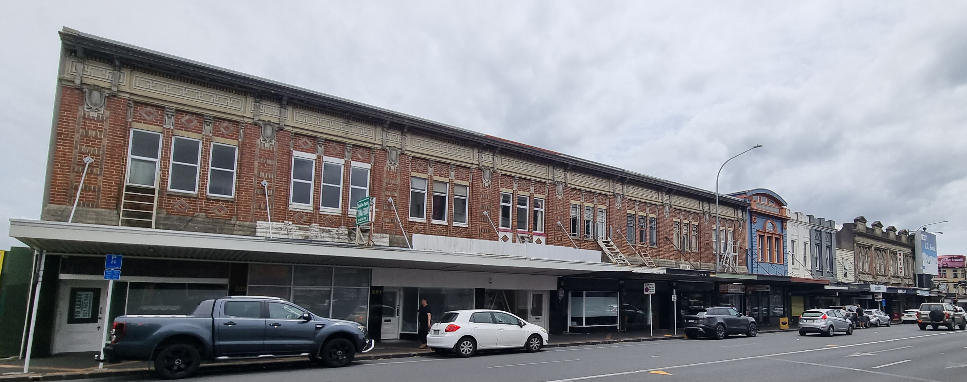
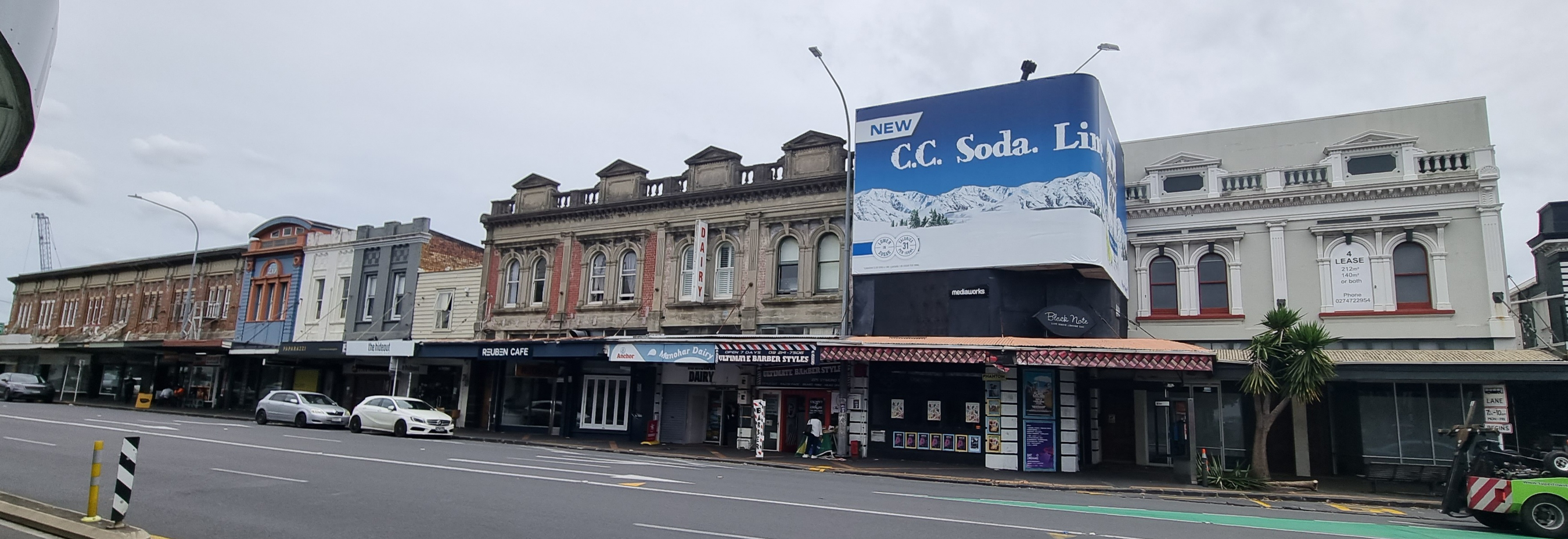
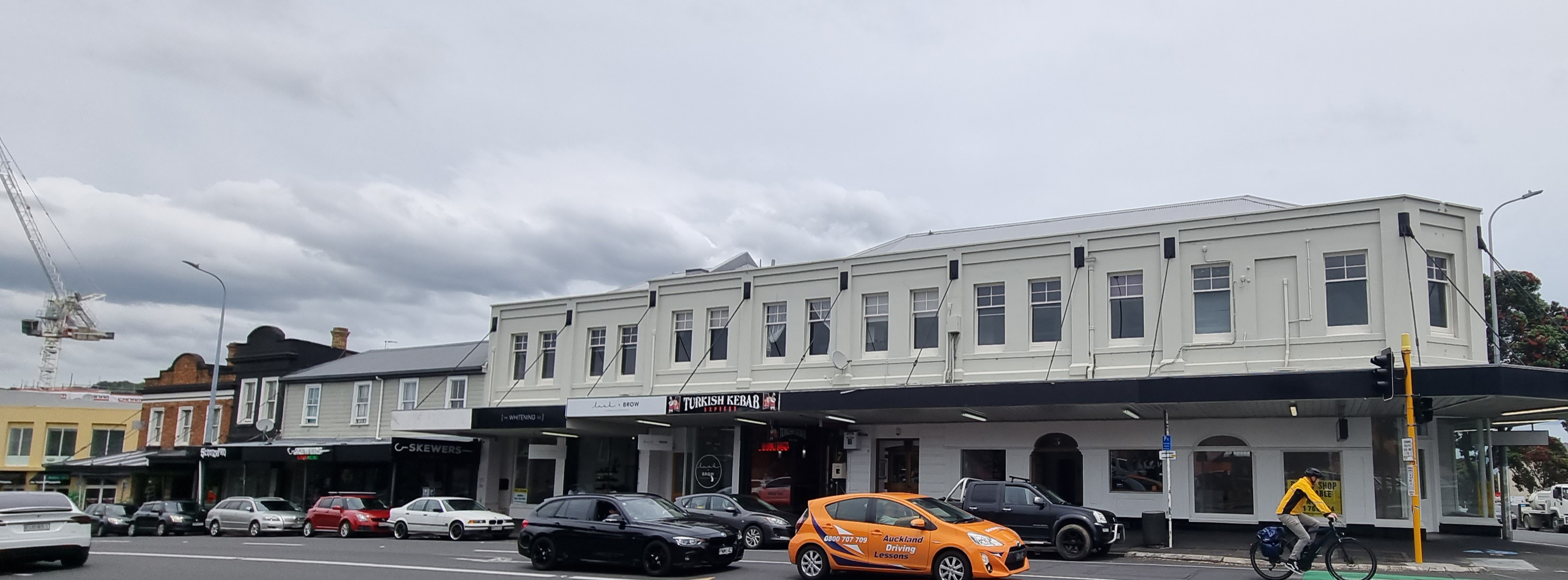
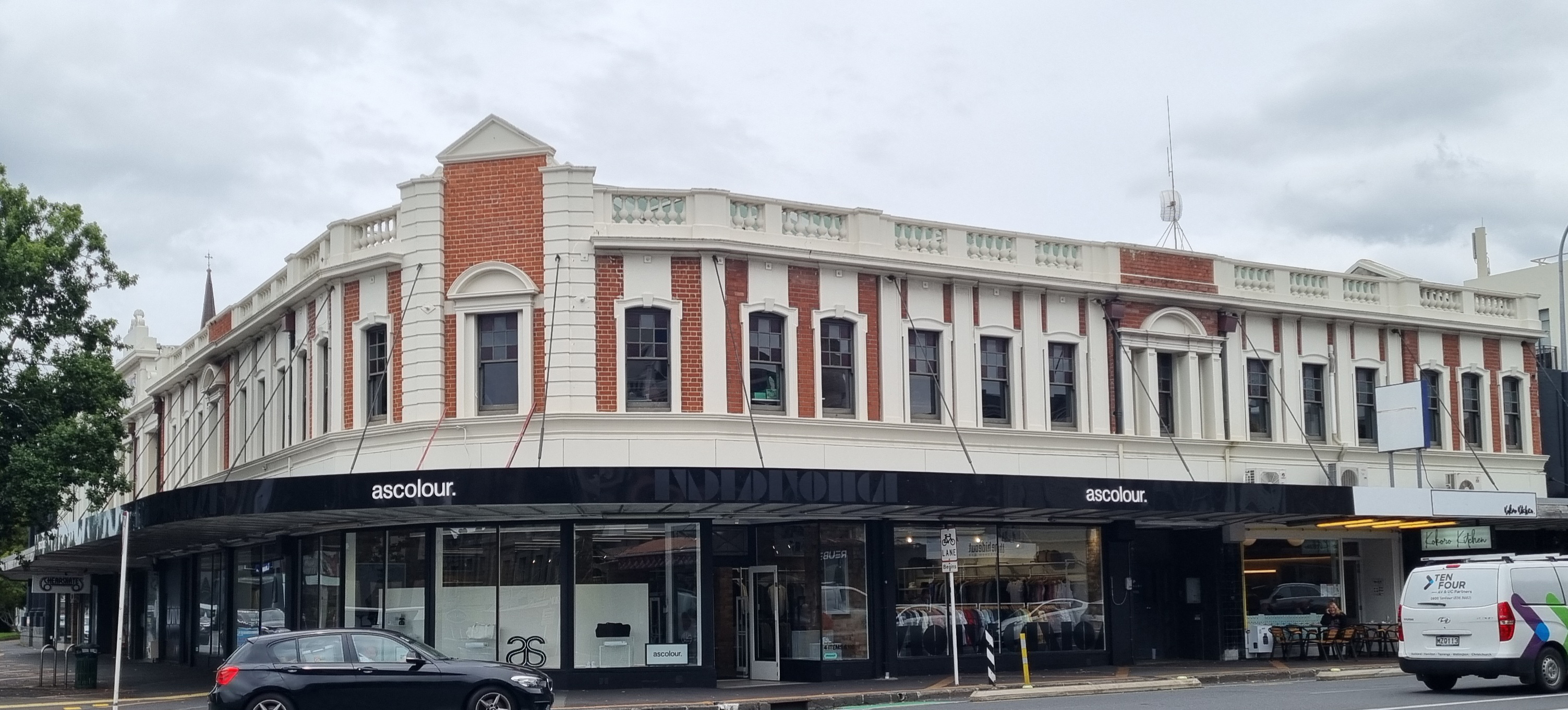
This historic area was registered under the Historic Places Act 1993. The following text is from the original Historic Area Assessment Under Section 23 Criteria report considered by the NZHPT Board at the time of registration. Architectural: The Upper Symonds Street area reached the height of its development around the turn of the century due to improved transport services in the form of the electric tram. The influx of people in to the area which this development facilitated clearly changed the type of building that had hitherto existed, for by 1900 the stock of buildings in the area had changed from being predominantly residential to being predominantly commercial, and it is the latter stock of buildings which has survived to the present time. The present architectural character of the area is therefore Victorian/Edwardian although there are some notable buildings from the Inter-War period. Virtually none of the retail ground floors of the shops are original, which is to be expected, although there are exceptions as with the c.1900 two storey timber building at 21 New North Road which is very reminiscent of an identical corner timber building which has also remained essentially unaltered, i.e. the Former Bank of New South Wales building, 1906, Hokitika (Cat.II). Above the verandahs, the facades of the Symonds Street area buildings have remained intact although in some cases they have been covered over by advertising boards, e.g. on the north side of Symonds Street, Nos. 211-213; 221-231. In other cases the original facades have been cemented over between the wars in imitation of a Stripped Classical style, e.g. Nos. 167;169; 153-55; and 187-191 Symonds Street. These alterations somewhat detract from the architectural quality of the area. Comparatively speaking for example, none of the Victorian/Edwardian buildings in the Cuba Street Historic Area, Wellington, have been subjected to the massive billboard which obscures the façade. The same can also be said for the proposed High Street, Christchurch, historic area of Victorian/Edwardian buildings. By the same token, cemented over turn-of-the-century facades is a common fate suffered by buildings in all three historic areas. There are one or two notable free-standing buildings in the area which should be identified not simply because of their good architectural detailing but because of their obvious key social significance. These are the churches, i.e. Church of the Holy Sepulchre Anglican Church (registered Category I) and St David's Presbyterian Church; places for socialising and entertainment, i.e. the Orange Coronation Hall and the Astor Hotel; public buildings, i.e. the Former Grafton Library; the service industries, i.e. the Winstone's Stables; and the banks and the post office, i.e. the Auckland Savings Bank, Khyber Pass Road; the Former BNZ, Symonds Street, and the Former Post Office, Symonds Street. The shops at 203-207 Symonds Street are an interesting and fair example of Victorian/Edwardian Commercial Italianate style shop-front architecture, but I would not describe them as "Queen Anne". The shops at numbers 173-175 are another example of the preferred Commercial Italianate style of the period. The glazed tile shops, Fullers, at 241-255 Symonds Street, are also a notable exercise in Inter-War Stripped Classical style architecture, and go a considerable way to raising the architectural quality of the area. The case for the landmark status of the buildings on the Khyber Pass (including the Astor Hotel) corner seems to be proved by the photographs of this intersection included in the proposal for registration of the Astor Hotel. In conclusion, there is enough architectural quality in the Upper Symonds Street historic area to warrant saying that it compares favourably in significance and value with the two other historic areas noted above. The case for registration has some additional support in respect of the fact that some buildings in the area were designed by at least two big-name architects of the period, i.e. Edward Mahoney (Church of the Holy Sepulchre Anglican Church) and R. A Abbot (Former BNZ, 164 Symonds Street).
Why is this place significant?
Cultural Significance
This historic area was registered under the Historic Places Act 1993. The following text is from the original Historic Area Assessment Under Section 23 Criteria report considered by the NZHPT Board at the time of registration. Social: The Upper Symonds Street area is very similar in terms of its social history, with that of the Cuba Street Historic Area in Wellington. There seems to be a general paradigm for areas in the major centres such as these where development was significantly enhanced by the introduction of horse drawn and then electric trams around the turn of the century, but significantly declined with the disappearance of the trams and a drop off in the number of people coming into the area as the social and economic infrastructure of the surrounding city changed. The community that was left tended in these circumstances to have a strong local identity but in the sense that it was a small community battling for survival on the outskirts of the central business district. The paradigm in this respect therefore became one where time, and development, stopped before the Second World War, and progressed little further beyond this point. The architecture has remained but in a run down state, while businesses and buildings have suffered the inevitable invasion of take-away bars, video parlours and other fringe retailing activities which tend to detract from the qualities and character of the earlier period.
Historic Significance
Historical Significance or Value This historic area was registered under the Historic Places Act 1993. The following text is from the original Historic Area Assessment Under Section 23 Criteria report considered by the NZHPT Board at the time of registration. Historical: From the evidence presented it is clear that this area was reshaped substantially between the l880s and the 1930s as it evolved from a residential to a retail/commercial servicing centre, Petry and Matthews say little about the people and processes involved, but it is clear that this development was partly shaped by changes to the transport system (just as present road widening proposals threaten one object, the Astor). Although different businesses and people appear to have been associated with these buildings, the area can be said to have had a shared history that may loosely be defined as a move from residential to commercial use late 19th century/early 20th century, followed by a long period of decline. That stagnation and decline has been responsible for preserving much of its earlier streetscape features without large-scale additions of modem buildings or the gentrification of Parnell and Devonport. As such, it may be 'A' typical of inner Auckland city areas. Petry and Matthews have sketched the Upper Symonds Street area's history and cultural use over the last two centuries. While considerably more information would be desirable (especially on the owners, occupiers and businesses associated with these structures), there is sufficient information to establish that the Upper Symonds Street areas forms part of the historical heritage of New Zealand, more particularly that of Auckland and its business history.
Physical Significance
This historic area was registered under the Historic Places Act 1993. The following text is from the original Historic Area Assessment Under Section 23 Criteria report considered by the NZHPT Board at the time of registration. Architectural: The Upper Symonds Street area reached the height of its development around the turn of the century due to improved transport services in the form of the electric tram. The influx of people in to the area which this development facilitated clearly changed the type of building that had hitherto existed, for by 1900 the stock of buildings in the area had changed from being predominantly residential to being predominantly commercial, and it is the latter stock of buildings which has survived to the present time. The present architectural character of the area is therefore Victorian/Edwardian although there are some notable buildings from the Inter-War period. Virtually none of the retail ground floors of the shops are original, which is to be expected, although there are exceptions as with the c.1900 two storey timber building at 21 New North Road which is very reminiscent of an identical corner timber building which has also remained essentially unaltered, i.e. the Former Bank of New South Wales building, 1906, Hokitika (Cat.II). Above the verandahs, the facades of the Symonds Street area buildings have remained intact although in some cases they have been covered over by advertising boards, e.g. on the north side of Symonds Street, Nos. 211-213; 221-231. In other cases the original facades have been cemented over between the wars in imitation of a Stripped Classical style, e.g. Nos. 167;169; 153-55; and 187-191 Symonds Street. These alterations somewhat detract from the architectural quality of the area. Comparatively speaking for example, none of the Victorian/Edwardian buildings in the Cuba Street Historic Area, Wellington, have been subjected to the massive billboard which obscures the façade. The same can also be said for the proposed High Street, Christchurch, historic area of Victorian/Edwardian buildings. By the same token, cemented over turn-of-the-century facades is a common fate suffered by buildings in all three historic areas. There are one or two notable free-standing buildings in the area which should be identified not simply because of their good architectural detailing but because of their obvious key social significance. These are the churches, i.e. Church of the Holy Sepulchre Anglican Church (registered Category I) and St David's Presbyterian Church; places for socialising and entertainment, i.e. the Orange Coronation Hall and the Astor Hotel; public buildings, i.e. the Former Grafton Library; the service industries, i.e. the Winstone's Stables; and the banks and the post office, i.e. the Auckland Savings Bank, Khyber Pass Road; the Former BNZ, Symonds Street, and the Former Post Office, Symonds Street. The shops at 203-207 Symonds Street are an interesting and fair example of Victorian/Edwardian Commercial Italianate style shop-front architecture, but I would not describe them as "Queen Anne". The shops at numbers 173-175 are another example of the preferred Commercial Italianate style of the period. The glazed tile shops, Fullers, at 241-255 Symonds Street, are also a notable exercise in Inter-War Stripped Classical style architecture, and go a considerable way to raising the architectural quality of the area. The case for the landmark status of the buildings on the Khyber Pass (including the Astor Hotel) corner seems to be proved by the photographs of this intersection included in the proposal for registration of the Astor Hotel. In conclusion, there is enough architectural quality in the Upper Symonds Street historic area to warrant saying that it compares favourably in significance and value with the two other historic areas noted above. The case for registration has some additional support in respect of the fact that some buildings in the area were designed by at least two big-name architects of the period, i.e. Edward Mahoney (Church of the Holy Sepulchre Anglican Church) and R. A Abbot (Former BNZ, 164 Symonds Street).
Historical and Associated Iwi / Hapū / Whānau
Other Information
A copy of the original report is available from the NZHPT Northern region office Please note that entry on the New Zealand Heritage List/Rarangi Korero identifies only the heritage values of the property concerned, and should not be construed as advice on the state of the property, or as a comment of its soundness or safety, including in regard to earthquake risk, safety in the event of fire, or insanitary conditions.
Sign up to hear more
Get the latest heritage news, features and events delivered
straight to your inbox.
