DonateSupporterVisit Heritage
  • Tūrangawaewae
    Places
  • Tira Māori
    Māori Heritage
  • Poutairangahia
    Archaeology
  • Rauemi
    Resources
  • Mō Tātou
    About Us
  • New Zealand Heritage List
  • Nominate and submit
  • Explore the List
  • National Historic Landmarks
  • Plaques
  • Rainbow List Project
  • Lost heritage
  • Visit Heritage
  • Our properties
  • Turnbull House Project
  • Collections
  • Shop
  • Tohu Whenua
  • Tira Māori
  • Conserving Māori heritage
  • Marae built heritage
  • Māori heritage on the List
  • Hinemihi—Te Hokinga Mai
  • What is archaeology?
  • Is there a site on my property?
  • What are my legal requirements?
  • Affecting an archaeological site
  • Declaring an archaeological site
  • Archaeology FAQs
  • Archaeology Digital Library
  • Archaeology guidelines and templates
  • Resources
  • Funding
  • Publications
  • Sustainable management guides
  • Disaster recovery
  • Podcasts & digital resources
  • Education Hub
  • Conservation plans
  • About
  • Board
  • Māori Heritage Council
  • Senior Staff
  • Offices
  • Contact us
  • Careers
  • Covenants
  • Fast-track
  • Corporate documents
  • Currently consulting on
  • Our submissions
  • News
  • Covid-19 response
Quick links
Rārangi Kōrero | The List
Explore the List
National Historic Landmarks
Ngā Manawhenua o Aotearoa me ōna Kōrero Tūturu
Quick links
Tapuwae
A Vision for Places of Māori Heritage
Funding for Māori Heritage
Resources
Quick links
Archaeological Authority Portal
Applying for an archaeological authority
Archaeology FAQs
Browse the most frequently asked questions about archaeological authorities and the archaeological process.
Quick links
Quick links
Contact us
Offices
DonateSupporterVisit Heritage
  • Tūrangawaewae
    Places
  • Tira Māori
    Māori Heritage
  • Poutairangahia
    Archaeology
  • Rauemi
    Resources
  • Mō Tātou
    About Us
  • New Zealand Heritage List
  • Nominate and submit
  • Explore the List
  • National Historic Landmarks
  • Plaques
  • Rainbow List Project
  • Lost heritage
  • Visit Heritage
  • Our properties
  • Turnbull House Project
  • Collections
  • Shop
  • Tohu Whenua
  • Tira Māori
  • Conserving Māori heritage
  • Marae built heritage
  • Māori heritage on the List
  • Hinemihi—Te Hokinga Mai
  • What is archaeology?
  • Is there a site on my property?
  • What are my legal requirements?
  • Affecting an archaeological site
  • Declaring an archaeological site
  • Archaeology FAQs
  • Archaeology Digital Library
  • Archaeology guidelines and templates
  • Resources
  • Funding
  • Publications
  • Sustainable management guides
  • Disaster recovery
  • Podcasts & digital resources
  • Education Hub
  • Conservation plans
  • About
  • Board
  • Māori Heritage Council
  • Senior Staff
  • Offices
  • Contact us
  • Careers
  • Covenants
  • Fast-track
  • Corporate documents
  • Currently consulting on
  • Our submissions
  • News
  • Covid-19 response
Quick links
Rārangi Kōrero | The List
Explore the List
National Historic Landmarks
Ngā Manawhenua o Aotearoa me ōna Kōrero Tūturu
Quick links
Tapuwae
A Vision for Places of Māori Heritage
Funding for Māori Heritage
Resources
Quick links
Archaeological Authority Portal
Applying for an archaeological authority
Archaeology FAQs
Browse the most frequently asked questions about archaeological authorities and the archaeological process.
Quick links
Quick links
Contact us
Offices
  • Places
  • Nominate and submit
  • National Historic Landmarks
  • Places
  • Nominate and submit
  • National Historic Landmarks
  • Tira Māori
  • Conserving Māori heritage
  • Marae built heritage
  • Tira Māori
  • Conserving Māori heritage
  • Marae built heritage
  • Archaeological authorities
  • Archaeology Digital Library
  • Archaeological authorities
  • Archaeology Digital Library
  • All resources
  • Publications
  • Funding
  • All resources
  • Publications
  • Funding
  • FAQs
  • FAQs
Follow us on:
Places
  • Places
  • Nominate and submit
  • National Historic Landmarks
Tira Māori
  • Tira Māori
  • Conserving Māori heritage
  • Marae built heritage
Archaeology
  • Archaeological authorities
  • Archaeology Digital Library
Resources
  • All resources
  • Publications
  • Funding
FAQs
  • FAQs
Follow us on
HomePrivacyTerms and conditionsAbout this site
© Heritage New Zealand Pouhere Taonga 2026.
 
Cashmere Drains Historic Area

Cashmere, CHRISTCHURCH

Private

Historic Area

List No. 7482

Quick links:
List GalleryLocationDetails
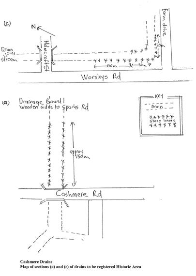
Cashmere Drains Historic Area. Plan of Historic Area from registration report. | 15/09/2000 | Heritage New Zealand Pouhere Taonga

List Entry Information

Overview

Status
Listed

List Entry Status
Historic Area

Access
Private/No Public Access

List Number
7482

Date Entered
15th September 2000

Date of Effect
15th September 2000

City/District Council
Christchurch City

Region
Canterbury Region

Extent of List Entry

The area comprises Cashmere Stream, Cashmere Valley Drain and Ballintine's Drain representing the Cashmere Drainage System.

Detailed List Entry
Significance

Historic Significance

Historical Significance or Value This historic area was registered under the Historic Places Act 1993. This report includes text from the original Historic Place Assessment Under Section 23 Criteria considered by the NZHPT Board at the time of registration. Historical: The Cashmere Stream and the Cashmere Valley and Ballintine's drains flowing into it were part of a system devised by Sir John Cracroft Wilson to drain his Cashmere Estate at the foot of Christchurch's Worsley's Road Spur in the early 1860s. Cracroft Wilson purchased the estate, including a large area of swamp, soon after he arrived in Christchurch in 1854. After another stint in the Indian Civil Service he returned to Christchurch in 1859 intent on draining the swamp for pastoral use. Almost immediately he set to work canalising and straightening the Cashmere Stream as the main drainage channel. He also organised the digging of ditches emptying into the stream. Two of these, the Cashmere Valley drain and Ballintine's drain, are of particular interest because they are partially lined with dressed stone. Cracroft Wilson's friend Alfred Cox stated in his biography that: "The system adopted was not the usual mode of treating swamps and not the most economical. Cracroft Wilson was not content to drain them and allow years to pass before fitting them to the plough, he did everything at once and by himself." In his book The Port Hills of Christchurch, Gordon Ogilvie writes: "At considerable cost and effort he drained the swamp in and adjoining Cashmere Valley and dug the Cashmere Stream doing much of the work with his own hands." Cracroft Wilson's papers reveal that he and his two neighbours Charles Bowen and H F Cridland offered to pay 50 pounds each for a drain approximately 4 metres wide and 35m at the bottom "from Wilson's promontory through the Cashmere Swamp to the road running south and north and bordering Mr Bowen's sections 1085 and 1105." This is the main section of the Cashmere Stream running from Sutherlands Road to the confluence with the Heathcote River. The three men also petitioned the Provincial Government to give them a grant for the work. A receipt dated 17 August 1863 reveals that Cracroft Wilson paid a total of 83 pounds 10 shillings to John Mally (sic) for digging 27 chains of the Cashmere River and 5 chains in the high ridge - presumably part of the stream which curves around the foot of Worsley's Spur. Another contract with the three Mumford brothers in 1864 to dig a ditch on Mr Chapman's land probably refers to the Ballintine's Drain. No specific record can be found of the dressed stone lining parts of the Cashmere Valley and Ballintine's Drains. However, since the drains were dug on privately-owned land, it is very likely they were lined at the time of construction.

Physical Description

This historic area was registered under the Historic Places Act 1993. This report includes text from the original Historic Place Assessment Under Section 23 Criteria considered by the NZHPT Board at the time of registration. The boundaries of the Historic Area are: - Ballintine's Drain from Sparks Road to junction with Cashmere Stream (south of Brookford Street); - The Cashmere Stream and banks from this junction of Ballintine's Drain to Worsley's Reserve; - The Cashmere Valley Drain from its junction with the Cashmere Stream to a point 20 metres south east from the corner of Worsley's Road and Farm Drive. Specific features are: I. Stone-lined sections of the Cashmere Valley and Ballintine's Drain 2. Timber-lined sections of the northern part of Ballintine's Drain.

Reference

Report Written By

A copy of the original report is available from the NZHPT Southern region office Please note that entry on the New Zealand Heritage List/Rarangi Korero identifies only the heritage values of the property concerned, and should not be construed as advice on the state of the property, or as a comment of its soundness or safety, including in regard to earthquake risk, safety in the event of fire, or insanitary conditions.

Further Information

Current Usages

Former Usages

General Usage:: Utilities

Specific Usage: Drain

Themes

Web Links

Overview

Status

Listed

List Entry Status

Historic Area

Access

Private/No Public Access

List Number

7482

Date Entered

15th September 2000

Date of Effect

15th September 2000

City/District Council

Christchurch City

Region

Canterbury Region

Extent of List Entry

The area comprises Cashmere Stream, Cashmere Valley Drain and Ballintine's Drain representing the Cashmere Drainage System.

Status

Listed

List Entry Status

Historic Area

Access

Private/No Public Access

List Number

7482

Date Entered

15th September 2000

Date of Effect

15th September 2000

City/District Council

Christchurch City

Region

Canterbury Region

Extent of List Entry

The area comprises Cashmere Stream, Cashmere Valley Drain and Ballintine's Drain representing the Cashmere Drainage System.

Significance

Why is this place significant?

Historic Significance

Historical Significance or Value This historic area was registered under the Historic Places Act 1993. This report includes text from the original Historic Place Assessment Under Section 23 Criteria considered by the NZHPT Board at the time of registration. Historical: The Cashmere Stream and the Cashmere Valley and Ballintine's drains flowing into it were part of a system devised by Sir John Cracroft Wilson to drain his Cashmere Estate at the foot of Christchurch's Worsley's Road Spur in the early 1860s. Cracroft Wilson purchased the estate, including a large area of swamp, soon after he arrived in Christchurch in 1854. After another stint in the Indian Civil Service he returned to Christchurch in 1859 intent on draining the swamp for pastoral use. Almost immediately he set to work canalising and straightening the Cashmere Stream as the main drainage channel. He also organised the digging of ditches emptying into the stream. Two of these, the Cashmere Valley drain and Ballintine's drain, are of particular interest because they are partially lined with dressed stone. Cracroft Wilson's friend Alfred Cox stated in his biography that: "The system adopted was not the usual mode of treating swamps and not the most economical. Cracroft Wilson was not content to drain them and allow years to pass before fitting them to the plough, he did everything at once and by himself." In his book The Port Hills of Christchurch, Gordon Ogilvie writes: "At considerable cost and effort he drained the swamp in and adjoining Cashmere Valley and dug the Cashmere Stream doing much of the work with his own hands." Cracroft Wilson's papers reveal that he and his two neighbours Charles Bowen and H F Cridland offered to pay 50 pounds each for a drain approximately 4 metres wide and 35m at the bottom "from Wilson's promontory through the Cashmere Swamp to the road running south and north and bordering Mr Bowen's sections 1085 and 1105." This is the main section of the Cashmere Stream running from Sutherlands Road to the confluence with the Heathcote River. The three men also petitioned the Provincial Government to give them a grant for the work. A receipt dated 17 August 1863 reveals that Cracroft Wilson paid a total of 83 pounds 10 shillings to John Mally (sic) for digging 27 chains of the Cashmere River and 5 chains in the high ridge - presumably part of the stream which curves around the foot of Worsley's Spur. Another contract with the three Mumford brothers in 1864 to dig a ditch on Mr Chapman's land probably refers to the Ballintine's Drain. No specific record can be found of the dressed stone lining parts of the Cashmere Valley and Ballintine's Drains. However, since the drains were dug on privately-owned land, it is very likely they were lined at the time of construction.

Why is this place significant?

Historic Significance

Historical Significance or Value This historic area was registered under the Historic Places Act 1993. This report includes text from the original Historic Place Assessment Under Section 23 Criteria considered by the NZHPT Board at the time of registration. Historical: The Cashmere Stream and the Cashmere Valley and Ballintine's drains flowing into it were part of a system devised by Sir John Cracroft Wilson to drain his Cashmere Estate at the foot of Christchurch's Worsley's Road Spur in the early 1860s. Cracroft Wilson purchased the estate, including a large area of swamp, soon after he arrived in Christchurch in 1854. After another stint in the Indian Civil Service he returned to Christchurch in 1859 intent on draining the swamp for pastoral use. Almost immediately he set to work canalising and straightening the Cashmere Stream as the main drainage channel. He also organised the digging of ditches emptying into the stream. Two of these, the Cashmere Valley drain and Ballintine's drain, are of particular interest because they are partially lined with dressed stone. Cracroft Wilson's friend Alfred Cox stated in his biography that: "The system adopted was not the usual mode of treating swamps and not the most economical. Cracroft Wilson was not content to drain them and allow years to pass before fitting them to the plough, he did everything at once and by himself." In his book The Port Hills of Christchurch, Gordon Ogilvie writes: "At considerable cost and effort he drained the swamp in and adjoining Cashmere Valley and dug the Cashmere Stream doing much of the work with his own hands." Cracroft Wilson's papers reveal that he and his two neighbours Charles Bowen and H F Cridland offered to pay 50 pounds each for a drain approximately 4 metres wide and 35m at the bottom "from Wilson's promontory through the Cashmere Swamp to the road running south and north and bordering Mr Bowen's sections 1085 and 1105." This is the main section of the Cashmere Stream running from Sutherlands Road to the confluence with the Heathcote River. The three men also petitioned the Provincial Government to give them a grant for the work. A receipt dated 17 August 1863 reveals that Cracroft Wilson paid a total of 83 pounds 10 shillings to John Mally (sic) for digging 27 chains of the Cashmere River and 5 chains in the high ridge - presumably part of the stream which curves around the foot of Worsley's Spur. Another contract with the three Mumford brothers in 1864 to dig a ditch on Mr Chapman's land probably refers to the Ballintine's Drain. No specific record can be found of the dressed stone lining parts of the Cashmere Valley and Ballintine's Drains. However, since the drains were dug on privately-owned land, it is very likely they were lined at the time of construction.

Physical Description

This historic area was registered under the Historic Places Act 1993. This report includes text from the original Historic Place Assessment Under Section 23 Criteria considered by the NZHPT Board at the time of registration. The boundaries of the Historic Area are: - Ballintine's Drain from Sparks Road to junction with Cashmere Stream (south of Brookford Street); - The Cashmere Stream and banks from this junction of Ballintine's Drain to Worsley's Reserve; - The Cashmere Valley Drain from its junction with the Cashmere Stream to a point 20 metres south east from the corner of Worsley's Road and Farm Drive. Specific features are: I. Stone-lined sections of the Cashmere Valley and Ballintine's Drain 2. Timber-lined sections of the northern part of Ballintine's Drain.

This historic area was registered under the Historic Places Act 1993. This report includes text from the original Historic Place Assessment Under Section 23 Criteria considered by the NZHPT Board at the time of registration. The boundaries of the Historic Area are: - Ballintine's Drain from Sparks Road to junction with Cashmere Stream (south of Brookford Street); - The Cashmere Stream and banks from this junction of Ballintine's Drain to Worsley's Reserve; - The Cashmere Valley Drain from its junction with the Cashmere Stream to a point 20 metres south east from the corner of Worsley's Road and Farm Drive. Specific features are: I. Stone-lined sections of the Cashmere Valley and Ballintine's Drain 2. Timber-lined sections of the northern part of Ballintine's Drain.

Reference

Historical and Associated Iwi / Hapū / Whānau

Other Information

A copy of the original report is available from the NZHPT Southern region office Please note that entry on the New Zealand Heritage List/Rarangi Korero identifies only the heritage values of the property concerned, and should not be construed as advice on the state of the property, or as a comment of its soundness or safety, including in regard to earthquake risk, safety in the event of fire, or insanitary conditions.

Historical and Associated Iwi / Hapū / Whānau

Other Information

A copy of the original report is available from the NZHPT Southern region office Please note that entry on the New Zealand Heritage List/Rarangi Korero identifies only the heritage values of the property concerned, and should not be construed as advice on the state of the property, or as a comment of its soundness or safety, including in regard to earthquake risk, safety in the event of fire, or insanitary conditions.

Further Information

Former Usages

General Usage: Utilities

Specific Usage: Drain

Former Usages

General Usage: Utilities

Specific Usage: Drain
Location

Loading
Related listings
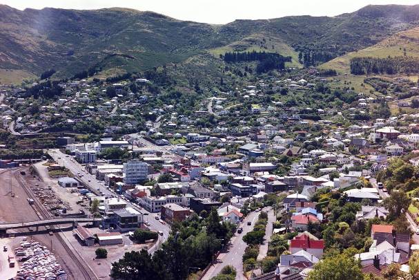
Lyttelton Township Historic Area. Cropped view from Timeball Site
Lyttelton Township Historic Area
Lyttelton Township Historic Area. Cropped view from Timeball Site
Lyttelton Township Historic Area
Sign up to hear more

Get the latest heritage news, features and events delivered
straight to your inbox.

Subscribe
