DonateSupporterVisit Heritage
  • Tūrangawaewae
    Places
  • Tira Māori
    Māori Heritage
  • Poutairangahia
    Archaeology
  • Rauemi
    Resources
  • Mō Tātou
    About Us
  • New Zealand Heritage List
  • Nominate and submit
  • Explore the List
  • National Historic Landmarks
  • Plaques
  • Rainbow List Project
  • Lost heritage
  • Visit Heritage
  • Our properties
  • Turnbull House Project
  • Collections
  • Shop
  • Tohu Whenua
  • Tira Māori
  • Conserving Māori heritage
  • Marae built heritage
  • Māori heritage on the List
  • Hinemihi—Te Hokinga Mai
  • What is archaeology?
  • Is there a site on my property?
  • What are my legal requirements?
  • Affecting an archaeological site
  • Declaring an archaeological site
  • Archaeology FAQs
  • Archaeology Digital Library
  • Archaeology guidelines and templates
  • Resources
  • Funding
  • Publications
  • Sustainable management guides
  • Disaster recovery
  • Podcasts & digital resources
  • Education Hub
  • Conservation plans
  • About
  • Board
  • Māori Heritage Council
  • Senior Staff
  • Offices
  • Contact us
  • Careers
  • Covenants
  • Fast-track
  • Corporate documents
  • Currently consulting on
  • Our submissions
  • News
Quick links
Rārangi Kōrero | The List
Explore the List
National Historic Landmarks
Ngā Manawhenua o Aotearoa me ōna Kōrero Tūturu
Quick links
Tapuwae
A Vision for Places of Māori Heritage
Funding for Māori Heritage
Resources
Quick links
Archaeological Authority Portal
Applying for an archaeological authority
Archaeology FAQs
Browse the most frequently asked questions about archaeological authorities and the archaeological process.
Quick links
Quick links
Contact us
Offices
DonateSupporterVisit Heritage
  • Tūrangawaewae
    Places
  • Tira Māori
    Māori Heritage
  • Poutairangahia
    Archaeology
  • Rauemi
    Resources
  • Mō Tātou
    About Us
  • New Zealand Heritage List
  • Nominate and submit
  • Explore the List
  • National Historic Landmarks
  • Plaques
  • Rainbow List Project
  • Lost heritage
  • Visit Heritage
  • Our properties
  • Turnbull House Project
  • Collections
  • Shop
  • Tohu Whenua
  • Tira Māori
  • Conserving Māori heritage
  • Marae built heritage
  • Māori heritage on the List
  • Hinemihi—Te Hokinga Mai
  • What is archaeology?
  • Is there a site on my property?
  • What are my legal requirements?
  • Affecting an archaeological site
  • Declaring an archaeological site
  • Archaeology FAQs
  • Archaeology Digital Library
  • Archaeology guidelines and templates
  • Resources
  • Funding
  • Publications
  • Sustainable management guides
  • Disaster recovery
  • Podcasts & digital resources
  • Education Hub
  • Conservation plans
  • About
  • Board
  • Māori Heritage Council
  • Senior Staff
  • Offices
  • Contact us
  • Careers
  • Covenants
  • Fast-track
  • Corporate documents
  • Currently consulting on
  • Our submissions
  • News
Quick links
Rārangi Kōrero | The List
Explore the List
National Historic Landmarks
Ngā Manawhenua o Aotearoa me ōna Kōrero Tūturu
Quick links
Tapuwae
A Vision for Places of Māori Heritage
Funding for Māori Heritage
Resources
Quick links
Archaeological Authority Portal
Applying for an archaeological authority
Archaeology FAQs
Browse the most frequently asked questions about archaeological authorities and the archaeological process.
Quick links
Quick links
Contact us
Offices
  • Places
  • Nominate and submit
  • National Historic Landmarks
  • Places
  • Nominate and submit
  • National Historic Landmarks
  • Tira Māori
  • Conserving Māori heritage
  • Marae built heritage
  • Tira Māori
  • Conserving Māori heritage
  • Marae built heritage
  • Archaeological authorities
  • Archaeology Digital Library
  • Archaeological authorities
  • Archaeology Digital Library
  • All resources
  • Publications
  • Funding
  • All resources
  • Publications
  • Funding
  • FAQs
  • FAQs
Follow us on:
Places
  • Places
  • Nominate and submit
  • National Historic Landmarks
Tira Māori
  • Tira Māori
  • Conserving Māori heritage
  • Marae built heritage
Archaeology
  • Archaeological authorities
  • Archaeology Digital Library
Resources
  • All resources
  • Publications
  • Funding
FAQs
  • FAQs
Follow us on
HomePrivacyTerms and conditionsAbout this site
© Heritage New Zealand Pouhere Taonga 2026.
 
Murphy's Flat Reserve Historic Area

Golden Bar Road, MACRAES

Private

Historic Area

List No. 7490

Quick links:
List GalleryLocationDetails
Murphy’s Flat, near Macraes Flat in Otago, a windswept isolated area set close to the vast modern open cast gold mining, is a reminder of the small scale alluvial gold mining that began the gold rush to this region in the mid-1860s.

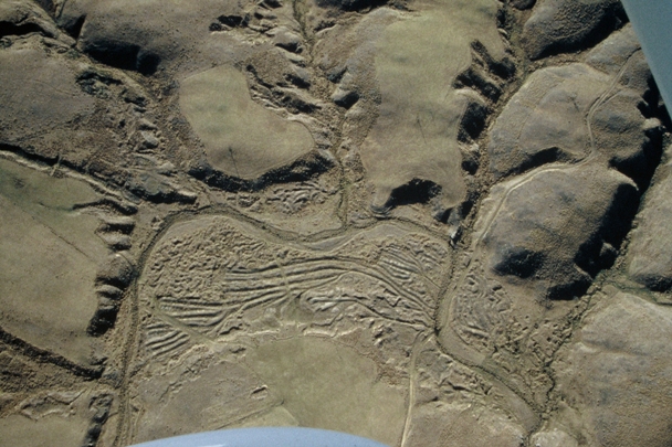
Murphy’s Flat is a large area, some 600 by 1000 metres in extent, which has been extensively worked for alluvial gold. The flat consists of a series of linear mounds of tailings, most probably built up as Murphy’s Creek was moved from side to side of the flat as the ground was worked. There are also several areas of pits and mounds that may be surviving evidence of some of the earliest working on the flat. Around the hillsides surrounding the flat there is extensive evidence of ground sluicing, along with water races, dams and reservoirs. Most of the side gullies contain workings, some very intensive. Though some areas have been damaged by ploughing the whole system is remarkably intact.

Several hut sites are located adjacent to the flat. A sod-walled enclosure and a reservoir are located close by in an area identified by an 1891 survey map as being the location of four ‘Chinaman’s huts’. Local tradition recalls this as the location of the ‘Leper’s Hut’, the home of a Chinese man, Hui Shing Tsoch (or Sin Tack), afflicted by leprosy who lived many years in isolation before dying in the hut.

To the south, Murphy’s Creek runs out of the flat through a narrow channel lined on one side with stacked stone, probably to maintain adequate fall from the flat. An adequate tailrace was as important as an adequate water supply to alluvial mining, to maintain water flow to work the ground, save the gold and wash away the tailings. A small area of quartz workings are located east of the flat, consisting of several adits and a small amount of surface working.

Murphy’s Flat is an important archaeological landscape. It is unusual to find linear mounds of tailings to such an extent across a wide flat ground. The archaeological features are in good condition and provide evidence of the types of mining systems used in the area. The Otago gold rushes were vital to the development of Otago, with Murphy’s Flat one memorial to that outstandingly important period in New Zealand’s history, recalling both Chinese and European experiences.

In 2007 Murphy’s Flat was gazetted as a historic reserve and is vested in the Department of Conservation.

The following text is from a report July 2001:

The history of Murphy's Flat is not well known, and there is some confusion in the documentation prior to 1865 as until then the name 'Murphy's Flat' appeared to have also been applied to the area now known as Macrae's Flat.

It is likely that gold was first discovered at the current Murphy's Flat in May 1862, with a rush in about November 1862, although there is some uncertainty as to the exact location of the sites mentioned in sources . Maps produced in 1867 show that Murphy's Flat had been worked for gold by this stage. By the late 1860s Murphy's Flat appears to have become something of a backwater.

Mining occurred again in the 1890s, this time by Chinese miners, in a typical goldfields scenario whereby Chinese miners methodically re-worked ground that European miners had earlier hurriedly dug over.

By the early years of the twentieth century Murphy's Flat appears to have become a virtually deserted location apart from a Chinese 'leper' living isolated in a hut on the Flat. An application in 1899 for a Prospecting Dredging Area on the flat appears to have come to nothing. As a result the tailings from the pre-1900 alluvial workings, all likely to be hand-worked, have remained untouched.
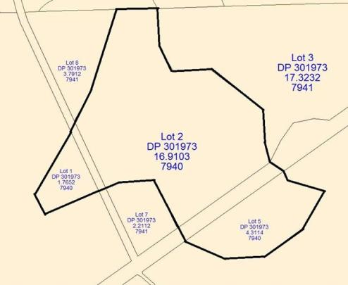
Map of Murphy's Flat Historic Area. | QuickMap®
Murphy's Flat Historic Area. Aerial View. July 1999 | Kevin L. Jones | Department of Conservation
Map of Murphy's Flat Historic Area. | QuickMap®
Murphy's Flat Historic Area. Aerial View. July 1999 | Kevin L. Jones | Department of Conservation

List Entry Information

Overview

Status
Listed

List Entry Status
Historic Area

Access
Private/No Public Access

List Number
7490

Date Entered
6th April 2001

Date of Effect
6th April 2001

City/District Council
Waitaki District

Region
Otago Region

Extent of List Entry

The extent includes the land described as Lots 1-2, 5 DP 301973, and legal road (RT 7940), Otago Land District, and the area known as Murphy's Flat Reserve Historic Area.

Legal description

Lots 1-2, 5 DP 301973, and legal road (RT 7940) (NZ Gazette 2007, p.2138), Otago Land District

Location Description

Located between Gifford Road and Golden Bar Road close to Murphy’s Creek. Access is from Golden Bar Road.

Detailed List Entry
Significance

Cultural Significance

Social: Murphy's Flat was an isolated mining valley where both European and Chinese miners worked. In 1891 a cluster of "Chinamen's huts" on the flat was recorded, suggesting a small Chinese mining community at that time. A Chinese man Hui Shing Tsoch, thought to have leprosy, was isolated in a hut at Murphy's Flat in approximately 1901 on a pension from the Waihemo County Council. He died at Murphy's Flat in 1907. This degree of isolation is indicative of the way in which both Chinese and lepers were viewed in the early twentieth century.

Historic Significance

Historical Significance or Value The historical importance of Murphy's Flat is its representation of early forms of alluvial mining which were in practice during the early years of the gold rush, and also the pattern of Chinese miners re-working European mining sites. Murphy's Flat is an important element of the goldfields history of Otago.

Physical Significance

Archaeological: Murphy's Flat is an important archaeological landscape. It was the scene of very early gold workings (ca 1862-3) with activity continuing intermittently until the turn of the century. The Flat (some 600m x 1000m in extent) has been extensively worked for gold. Mining techniques represented archaeologically on the Flat include ground sluicing around the margins and river bed workings on the Flat itself. Of particular note are the long sinuous mounds of tailings formed as the creek was progressively moved to work the ground. These sinuous tailings are highly unusual on such a scale and in such good condition. There are also several areas of pits and mounds that may be surviving evidence of some of the earliest working on the Flat. Around the hillsides surrounding the Flat there is extensive evidence of ground sluicing, along with water races, dams and reservoirs. Most of the side gullies also contain workings, some very intensive. A small area of quartz workings are located on the east of the Flat, consisting of several adits and a small amount of surface working. Murphy's Creek runs out of the Flat through a narrow channel lined on one side with stacked stone. Several hut sites are located adjacent to the Flat. These have been damaged but are still easily identifiable. A possible sod-walled enclosure and a reservoir are located close by. An 1891 survey map shows four “Chinamen's huts' in this location. Murphy's Flat is also significant in that it forms part of the wider historic archaeological landscape of the Macraes Flat area as an example of early alluvial mining techniques. It complements other notable sites in the area which are associated with different aspects or eras of mining in the Macraes area (gold rush mining, settled alluvial mining, hard rock mining, Chinese mining, modern mining, plus house sites associated with these). All the archaeological features on the site are in good condition. Many other areas of alluvial workings have been destroyed or damaged by cultivation but with the exception of a track and a fenceline, Murphy's Flat has escaped relatively unscathed. It thus has the potential to provide an information source for archaeologists and the public on the early gold rush era and the later Chinese mining era. Technological: The site shows a variety of mining techniques used during the pre-1900 gold mining period, including ground sluicing around the margins and river bed workings. Particularly notable are the sinuous tailings which are highly unusual on such a scale.

Reference

Public NZAA Number

I42/40

Completion Date

24th July 2001

Report Written By

Janet Stephenson

Information Sources

Beaglehole, nd

A Beaglehole, 'Buildings Classification Committee - Research Report Westoe Homestead, Kakariki', nd. Held on file at NZHPT, Wellington.

Hamel, 1991

G E Hamel, Changes in Gold Mining at Macraes. Report to Macraes Mining, 1991

Hamel, 2000

G E Hamel, East of the Taieri River; The Archaeology of the Macraes Ecological District, Department of Conservation, 2000

Petchey, 1996

P Petchey, Murphy's Flat - The History of the Murphy's Flat Diggings, Macraes. Report for Macraes Mining Company, April 1996

Report Written By

A copy of the original report is available from the NZHPT Southern region office Please note that entry on the New Zealand Heritage List/Rarangi Korero identifies only the heritage values of the property concerned, and should not be construed as advice on the state of the property, or as a comment of its soundness or safety, including in regard to earthquake risk, safety in the event of fire, or insanitary conditions.

Further Information

Current Usages

Uses: Civic Facilities

Specific Usage: Historic or recreation reserve

Former Usages

General Usage:: Mining

Specific Usage: Alluvial Workings

Themes

Cultures (other than Maori and Pakeha)

Web Links

Overview

Status

Listed

List Entry Status

Historic Area

Access

Private/No Public Access

List Number

7490

Date Entered

6th April 2001

Date of Effect

6th April 2001

City/District Council

Waitaki District

Region

Otago Region

Extent of List Entry

The extent includes the land described as Lots 1-2, 5 DP 301973, and legal road (RT 7940), Otago Land District, and the area known as Murphy's Flat Reserve Historic Area.

Legal description

Lots 1-2, 5 DP 301973, and legal road (RT 7940) (NZ Gazette 2007, p.2138), Otago Land District

Location Description

Located between Gifford Road and Golden Bar Road close to Murphy’s Creek. Access is from Golden Bar Road.

Status

Listed

List Entry Status

Historic Area

Access

Private/No Public Access

List Number

7490

Date Entered

6th April 2001

Date of Effect

6th April 2001

City/District Council

Waitaki District

Region

Otago Region

Extent of List Entry

The extent includes the land described as Lots 1-2, 5 DP 301973, and legal road (RT 7940), Otago Land District, and the area known as Murphy's Flat Reserve Historic Area.

Legal description

Lots 1-2, 5 DP 301973, and legal road (RT 7940) (NZ Gazette 2007, p.2138), Otago Land District

Location Description

Located between Gifford Road and Golden Bar Road close to Murphy’s Creek. Access is from Golden Bar Road.

Significance

Why is this place significant?

Cultural Significance

Social: Murphy's Flat was an isolated mining valley where both European and Chinese miners worked. In 1891 a cluster of "Chinamen's huts" on the flat was recorded, suggesting a small Chinese mining community at that time. A Chinese man Hui Shing Tsoch, thought to have leprosy, was isolated in a hut at Murphy's Flat in approximately 1901 on a pension from the Waihemo County Council. He died at Murphy's Flat in 1907. This degree of isolation is indicative of the way in which both Chinese and lepers were viewed in the early twentieth century.

Historic Significance

Historical Significance or Value The historical importance of Murphy's Flat is its representation of early forms of alluvial mining which were in practice during the early years of the gold rush, and also the pattern of Chinese miners re-working European mining sites. Murphy's Flat is an important element of the goldfields history of Otago.

Physical Significance

Archaeological: Murphy's Flat is an important archaeological landscape. It was the scene of very early gold workings (ca 1862-3) with activity continuing intermittently until the turn of the century. The Flat (some 600m x 1000m in extent) has been extensively worked for gold. Mining techniques represented archaeologically on the Flat include ground sluicing around the margins and river bed workings on the Flat itself. Of particular note are the long sinuous mounds of tailings formed as the creek was progressively moved to work the ground. These sinuous tailings are highly unusual on such a scale and in such good condition. There are also several areas of pits and mounds that may be surviving evidence of some of the earliest working on the Flat. Around the hillsides surrounding the Flat there is extensive evidence of ground sluicing, along with water races, dams and reservoirs. Most of the side gullies also contain workings, some very intensive. A small area of quartz workings are located on the east of the Flat, consisting of several adits and a small amount of surface working. Murphy's Creek runs out of the Flat through a narrow channel lined on one side with stacked stone. Several hut sites are located adjacent to the Flat. These have been damaged but are still easily identifiable. A possible sod-walled enclosure and a reservoir are located close by. An 1891 survey map shows four “Chinamen's huts' in this location. Murphy's Flat is also significant in that it forms part of the wider historic archaeological landscape of the Macraes Flat area as an example of early alluvial mining techniques. It complements other notable sites in the area which are associated with different aspects or eras of mining in the Macraes area (gold rush mining, settled alluvial mining, hard rock mining, Chinese mining, modern mining, plus house sites associated with these). All the archaeological features on the site are in good condition. Many other areas of alluvial workings have been destroyed or damaged by cultivation but with the exception of a track and a fenceline, Murphy's Flat has escaped relatively unscathed. It thus has the potential to provide an information source for archaeologists and the public on the early gold rush era and the later Chinese mining era. Technological: The site shows a variety of mining techniques used during the pre-1900 gold mining period, including ground sluicing around the margins and river bed workings. Particularly notable are the sinuous tailings which are highly unusual on such a scale.

Why is this place significant?

Cultural Significance

Social: Murphy's Flat was an isolated mining valley where both European and Chinese miners worked. In 1891 a cluster of "Chinamen's huts" on the flat was recorded, suggesting a small Chinese mining community at that time. A Chinese man Hui Shing Tsoch, thought to have leprosy, was isolated in a hut at Murphy's Flat in approximately 1901 on a pension from the Waihemo County Council. He died at Murphy's Flat in 1907. This degree of isolation is indicative of the way in which both Chinese and lepers were viewed in the early twentieth century.

Historic Significance

Historical Significance or Value The historical importance of Murphy's Flat is its representation of early forms of alluvial mining which were in practice during the early years of the gold rush, and also the pattern of Chinese miners re-working European mining sites. Murphy's Flat is an important element of the goldfields history of Otago.

Physical Significance

Archaeological: Murphy's Flat is an important archaeological landscape. It was the scene of very early gold workings (ca 1862-3) with activity continuing intermittently until the turn of the century. The Flat (some 600m x 1000m in extent) has been extensively worked for gold. Mining techniques represented archaeologically on the Flat include ground sluicing around the margins and river bed workings on the Flat itself. Of particular note are the long sinuous mounds of tailings formed as the creek was progressively moved to work the ground. These sinuous tailings are highly unusual on such a scale and in such good condition. There are also several areas of pits and mounds that may be surviving evidence of some of the earliest working on the Flat. Around the hillsides surrounding the Flat there is extensive evidence of ground sluicing, along with water races, dams and reservoirs. Most of the side gullies also contain workings, some very intensive. A small area of quartz workings are located on the east of the Flat, consisting of several adits and a small amount of surface working. Murphy's Creek runs out of the Flat through a narrow channel lined on one side with stacked stone. Several hut sites are located adjacent to the Flat. These have been damaged but are still easily identifiable. A possible sod-walled enclosure and a reservoir are located close by. An 1891 survey map shows four “Chinamen's huts' in this location. Murphy's Flat is also significant in that it forms part of the wider historic archaeological landscape of the Macraes Flat area as an example of early alluvial mining techniques. It complements other notable sites in the area which are associated with different aspects or eras of mining in the Macraes area (gold rush mining, settled alluvial mining, hard rock mining, Chinese mining, modern mining, plus house sites associated with these). All the archaeological features on the site are in good condition. Many other areas of alluvial workings have been destroyed or damaged by cultivation but with the exception of a track and a fenceline, Murphy's Flat has escaped relatively unscathed. It thus has the potential to provide an information source for archaeologists and the public on the early gold rush era and the later Chinese mining era. Technological: The site shows a variety of mining techniques used during the pre-1900 gold mining period, including ground sluicing around the margins and river bed workings. Particularly notable are the sinuous tailings which are highly unusual on such a scale.

Reference

Historical and Associated Iwi / Hapū / Whānau

Public NZAA Number

I42/40

Completion Date

24th July 2001

Report Written By

Janet Stephenson

Information Sources

Beaglehole, nd

A Beaglehole, 'Buildings Classification Committee - Research Report Westoe Homestead, Kakariki', nd. Held on file at NZHPT, Wellington.

Hamel, 1991

G E Hamel, Changes in Gold Mining at Macraes. Report to Macraes Mining, 1991

Hamel, 2000

G E Hamel, East of the Taieri River; The Archaeology of the Macraes Ecological District, Department of Conservation, 2000

Petchey, 1996

P Petchey, Murphy's Flat - The History of the Murphy's Flat Diggings, Macraes. Report for Macraes Mining Company, April 1996

Other Information

A copy of the original report is available from the NZHPT Southern region office Please note that entry on the New Zealand Heritage List/Rarangi Korero identifies only the heritage values of the property concerned, and should not be construed as advice on the state of the property, or as a comment of its soundness or safety, including in regard to earthquake risk, safety in the event of fire, or insanitary conditions.

Historical and Associated Iwi / Hapū / Whānau

Public NZAA Number

I42/40

Completion Date

24th July 2001

Report Written By

Janet Stephenson

Information Sources

Beaglehole, nd

A Beaglehole, 'Buildings Classification Committee - Research Report Westoe Homestead, Kakariki', nd. Held on file at NZHPT, Wellington.

Hamel, 1991

G E Hamel, Changes in Gold Mining at Macraes. Report to Macraes Mining, 1991

Hamel, 2000

G E Hamel, East of the Taieri River; The Archaeology of the Macraes Ecological District, Department of Conservation, 2000

Petchey, 1996

P Petchey, Murphy's Flat - The History of the Murphy's Flat Diggings, Macraes. Report for Macraes Mining Company, April 1996

Other Information

A copy of the original report is available from the NZHPT Southern region office Please note that entry on the New Zealand Heritage List/Rarangi Korero identifies only the heritage values of the property concerned, and should not be construed as advice on the state of the property, or as a comment of its soundness or safety, including in regard to earthquake risk, safety in the event of fire, or insanitary conditions.

Further Information

Current Usages

Uses: Civic Facilities

Specific Usage: Historic or recreation reserve

Former Usages

General Usage: Mining

Specific Usage: Alluvial Workings

Themes

Cultures (other than Maori and Pakeha)

Current Usages

Uses: Civic Facilities

Specific Usage: Historic or recreation reserve

Former Usages

General Usage: Mining

Specific Usage: Alluvial Workings

Themes

Cultures (other than Maori and Pakeha)

Location

Loading
Related listings
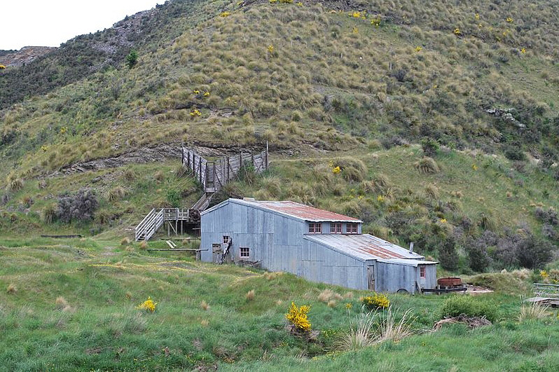
Golden Point Historic Area. Callery's battery. CC BY 3.0 Image courtesy of commons.wikimedia.org
Golden Point Historic Area
Golden Point Historic Area. Callery's battery. CC BY 3.0 Image courtesy of commons.wikimedia.org
Golden Point Historic Area
Sign up to hear more

Get the latest heritage news, features and events delivered
straight to your inbox.

Subscribe