

Okahupokia pā was inhabited by the Ngāti Hauiti tūpuna Hauiti, and was described in the Māori Land Court evidence of Utiku Pōtaka, Rakura Hunia and Hana Hinemanu during the 1894 hearing of the Otamakapua No. 1 Block. Okahupokia pā and nearby sites such as Omanono pā and Korihirau pā are of cultural and traditional importance as they signify the presence of Ngāti Hauiti occupation throughout this landscape from prehistory to the current day.
Okahupokia Pā was recently rediscovered by Te Rūnanga o Ngāti Hauiti after local historian Allen Shaw mentioned it at a school reunion. Shaw had been shown the site approximately 30 years prior and was able to point out the general vicinity of the site. Okahupokia pā is situated within farmland and is currently accessible by stock.
List Entry Information
Status
Listed
List Entry Status
Historic Place Category 2
Access
Private/No Public Access
List Number
7611
Date Entered
24th June 2005
Date of Effect
24th June 2005
City/District Council
Manawatū District
Region
Horizons (Manawatū-Whanganui) Region
Extent of List Entry
The registration includes the archaeological site of Okakupokia Pa (as shown in Appendix 5 of the Registration Report) with a buffer zone of 50 metres at the western end of the pa which includes the large flat (c. 40m x 40m) that would have been suitable for gardening, on Pt Lot 21, Deposited Plan 5866, Wellington Registry.
Legal description
Pt Lot 21 DP 5866 (RTs WN418/258, WNF1/18), Wellington Land District
Location Description
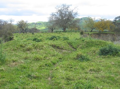
Okahupokia Pa is located on the eastern bank of the Rangitikei River, roughly 500 metres upstream from the Otara Bridge and is accessed via Otara Road through private land. The ditch and bank at the entrance to the pa is clearly visible from the flats below.
Status
Listed
List Entry Status
Historic Place Category 2
Access
Private/No Public Access
List Number
7611
Date Entered
24th June 2005
Date of Effect
24th June 2005
City/District Council
Manawatū District
Region
Horizons (Manawatū-Whanganui) Region
Extent of List Entry
The registration includes the archaeological site of Okakupokia Pa (as shown in Appendix 5 of the Registration Report) with a buffer zone of 50 metres at the western end of the pa which includes the large flat (c. 40m x 40m) that would have been suitable for gardening, on Pt Lot 21, Deposited Plan 5866, Wellington Registry.
Legal description
Pt Lot 21 DP 5866 (RTs WN418/258, WNF1/18), Wellington Land District
Location Description
Okahupokia Pa is located on the eastern bank of the Rangitikei River, roughly 500 metres upstream from the Otara Bridge and is accessed via Otara Road through private land. The ditch and bank at the entrance to the pa is clearly visible from the flats below.
Why is this place significant?
Cultural Significance
Okahupokia Pa was nominated as a site of cultural significance by Te Runanga o Ngati Hauiti during consultation with the NZHPT as part of the Central Region Pilot Project. Okahupokia Pa was one of the principal 'living places' of the Ngati Hauiti tupuna, Hauiti, and was described in the Maori Land Court evidence of Utiku Potaka, Rakera Hunia and Hana Hinemanu during the 1894 hearing of the Otamakapua No. 1 Block. Okahupokia Pa and nearby sites such as Omanono pa and Korihirau pa (see Appendix 3) are of cultural and traditional importance as they signify the presence of Ngati Hauiti occupation throughout this landscape from prehistory to the current day.
Historic Significance
Historical Significance or Value Okahupokia Pa is historically significant as it was one of the main occupation sites of Hauiti, the eponymous ancestor of Ngati Hauiti who was integral to the Maori Land Court evidence of Utiku Potaka and his fellow claimants during hearings for the Otamakapua No. 1 Block. These claimants were applying for the title of the Otamakapua No. 1 Block "on the basis of ancestry - through the tupuna Hauiti - and permanent undisturbed occupation".
Physical Significance
Okahupokia Pa is archaeologically significant as it is an outstanding example of the use of natural defences in the construction of a pa. It is also an excellent example of the strategic positioning of pa so as to provide outstanding vantage points and close access to economic resources such as those that would have been provided by the Rangitikei River.
Why is this place Category 1 / Category 2?
Detail Of Assessed Criteria
(c) The potential of the place to provide knowledge of New Zealand history. Although excavation is not recommended because of its destructive nature, there is potential for an archaeological investigation of Okahupokia Pa to reveal important information about prehistoric Maori settlement within the Rangitikei region, and to provide a date of occupation for the pa itself. (d) The importance of the place to tangata whenua Okahupokia Pa is a culturally significant site to Ngati Hauiti, who have occupied the Rangitikei region for many generations. It is a physical link to their ancestral past and they are keen to see it preserved for future generations. (g) 'The technical accomplishment or value, or design of the place Okahupokia Pa was strategically designed by the ancestors of Ngati Hauiti so as to take advantage of the natural defences provided by this ridge high above the Rangitikei River. Artificial defences were only necessary at the western end of the pa, where the remains of the double ditch and bank are visible today. The location of Okahupokia Pa would also have been chosen because of the commanding views that it provides of the surrounding landscape. (i) The importance of identifying historic places known to date from early periods of New Zealand settlement. Okahupokia Pa is likely to postdate 1500AD when pa construction is believed to have first begun but a more specific date would require scientific archaeological dating. A genealogical table reproduced in T.W. Downes' (1909) 'Early history of Rangitikei, and notes on the Ngati Apa tribe' (see Appendix 5) provides a potential insight into the possible antiquity of Okahupokia pa, but the incorporation of traditional Maori history into archaeological inquiry must be treated with caution and the accuracy of Downes' work is questionable.
Construction Materials
Archaeological site - double ditch and bank defences evidence of original construction
Notable Features
Double ditch and bank defence
Construction Materials
Archaeological site - double ditch and bank defences evidence of original construction
Notable Features
Double ditch and bank defence
Very little is known about the history of Okahupokia Pa and the period in which it was occupied, but Maori Land Court evidence presented during the partition hearing for the Otamakapua No. 1 block in 1894 indicates that it was a fighting pa of the Ngati Hauiti ancestor 'Hauiti'. Traditional tribal history indicates that Hauiti descended from the eponymous explorer Tamatea Pokai Whenua from the Takitimu canoe who is attributed with naming many localities within the northern Rangitikei district, and with leaving a number of mokai (pets) at certain places. Haywood (2003) states, "upon these foundations came Hauiti who permanently occupied the central Rangitikei valley and built several pa (fortified settlements) and kainga (settlements) throughout the region". Utiku Potaka of Rata stated in his Maori Land Court evidence: "I live at Rata. I have a claim to have a portion of this block allotted to me - Otara was the pa of my ancestors. It is on this block. Okahupokia was another pa". Utiku Potaka then asserted that he claimed "from Hauiti"and informed the Court that: "Otara was Hauiti's pa - Okahupokia was another of his pas [sic] also on the river". Rakera Hunia of Ngati Upokoiri and Ngati Hinemanu similarly told the court: "I am descended from Hauiti - Hauiti lived on this land - Otara was one of Hauiti's kaingas [sic]. Okahupokia and Ohuarere were also places of his". A third witness, Hana Hinemanu of Ngati Hauiti and Ngati Tumokai stated of Otamakapua No. 1: "Tumokai and his descendents lived on this block, and also No. 2 with the descendants of Hauiti". Okahupokia a pa and Otara were the principal places. Then they spread inland -They lived all over the country right up to Awarua. They had a cultivation at Te Ripo behind Okahupokia also at Otara". Okahupokia Pa was recently rediscovered after local historian Allen Shaw mentioned it at a school reunion. Shaw had been shown the site approximately 30 years prior and was able to point out the general vicinity of the site.
Very little is known about the history of Okahupokia Pa and the period in which it was occupied, but Maori Land Court evidence presented during the partition hearing for the Otamakapua No. 1 block in 1894 indicates that it was a fighting pa of the Ngati Hauiti ancestor 'Hauiti'. Traditional tribal history indicates that Hauiti descended from the eponymous explorer Tamatea Pokai Whenua from the Takitimu canoe who is attributed with naming many localities within the northern Rangitikei district, and with leaving a number of mokai (pets) at certain places. Haywood (2003) states, "upon these foundations came Hauiti who permanently occupied the central Rangitikei valley and built several pa (fortified settlements) and kainga (settlements) throughout the region". Utiku Potaka of Rata stated in his Maori Land Court evidence: "I live at Rata. I have a claim to have a portion of this block allotted to me - Otara was the pa of my ancestors. It is on this block. Okahupokia was another pa". Utiku Potaka then asserted that he claimed "from Hauiti"and informed the Court that: "Otara was Hauiti's pa - Okahupokia was another of his pas [sic] also on the river". Rakera Hunia of Ngati Upokoiri and Ngati Hinemanu similarly told the court: "I am descended from Hauiti - Hauiti lived on this land - Otara was one of Hauiti's kaingas [sic]. Okahupokia and Ohuarere were also places of his". A third witness, Hana Hinemanu of Ngati Hauiti and Ngati Tumokai stated of Otamakapua No. 1: "Tumokai and his descendents lived on this block, and also No. 2 with the descendants of Hauiti". Okahupokia a pa and Otara were the principal places. Then they spread inland -They lived all over the country right up to Awarua. They had a cultivation at Te Ripo behind Okahupokia also at Otara". Okahupokia Pa was recently rediscovered after local historian Allen Shaw mentioned it at a school reunion. Shaw had been shown the site approximately 30 years prior and was able to point out the general vicinity of the site.
Okahupokia Pa is strategically located on a steep, narrow ridge above the Rangitikei River that provides excellent natural defences, and sweeping views of the surrounding landscape. The inhabitants of Okahupokia Pa would have had easy access to the economic resources of the Rangitikei River and there is a large flat area approximately 40 metres square beyond the western edge of the pa that may have been utilised for gardening. The remains of a double ditch and bank defence are visible at the western end of the pa and there are several faint depressions in the interior of the pa that may tentatively be interpreted as house floors. Okahupokia Pa is situated within farmland and is currently accessible by stock. The remains of the ditch and bank defences have experienced considerable damage as a result of stock track erosion. There is also evidence of slips along the steep northern face of the ridge, indicating that the site is also prone to natural erosion processes.
Okahupokia Pa is strategically located on a steep, narrow ridge above the Rangitikei River that provides excellent natural defences, and sweeping views of the surrounding landscape. The inhabitants of Okahupokia Pa would have had easy access to the economic resources of the Rangitikei River and there is a large flat area approximately 40 metres square beyond the western edge of the pa that may have been utilised for gardening. The remains of a double ditch and bank defence are visible at the western end of the pa and there are several faint depressions in the interior of the pa that may tentatively be interpreted as house floors. Okahupokia Pa is situated within farmland and is currently accessible by stock. The remains of the ditch and bank defences have experienced considerable damage as a result of stock track erosion. There is also evidence of slips along the steep northern face of the ridge, indicating that the site is also prone to natural erosion processes.
Historical and Associated Iwi / Hapū / Whānau
Public NZAA Number
T22/22
Report Written By
Jo Wylie
Information Sources
Archives New Zealand (Wgtn)
Archives New Zealand (Wellington)
Downes, 1909
T. W. Downes, 'Early history of Rangitikei, and notes on the Ngati Apa tribe'. Transactions of the New Zealand Institute, Vol. XLII, 1909
Haywood, 2003
M Haywood, Rata: In the Heart of the Rangitikei. Hamilton: M Haywood, 2003
Morrow, 2002
D. Morrow, 'Iwi Interests in the Manawatu, c. 1820-1910'. A report for the Office of Treaty Settlements, 2002.
Other Information
Iwi - Ngati Hauiti Please note that entry on the New Zealand Heritage List/Rarangi Korero identifies only the heritage values of the property concerned, and should not be construed as advice on the state of the property, or as a comment of its soundness or safety, including in regard to earthquake risk, safety in the event of fire, or insanitary conditions.
Current Usages
Uses: Agriculture
Specific Usage: Farm
Former Usages
General Usage: Maori
Specific Usage: Pā
Themes
Of Significance to Maori
Current Usages
Uses: Agriculture
Specific Usage: Farm
Former Usages
General Usage: Maori
Specific Usage: Pā
Themes
Of Significance to Maori
Location
Sign up to hear more
Get the latest heritage news, features and events delivered
straight to your inbox.
