It is likely that in pre-European times the Karori Reservoir Valley was used by Maori for birdtrapping and collecting food, although they do not appear to have lived in the area. Indeed, the word Karori is derived from Karore which came from kaha or ka (ropes) and rore (snare) and therefore means 'snare ropes'. The recognised iwi authority in the area is Te Ati Awa and its people Tangata Whenua.
European settlement began in the Karori area following the purchase of the Wellington region by the New Zealand Company in 1839. By the 1850s the bush had been largely removed, and sheep and cattle were grazed on the land. In 1871, several landowners were affected by the Wellington Water Works Act which, for the purpose of supplying the city with water, took 228 acres of land along the Kaiwharawhara Stream. In 1878 a dam was completed in the lower part of the Kaiwharawhara valley (to be known as the Lower Karori Dam). Farming continued in the upper part of the valley, where stock was run on open grassland and scrub.
There was great confidence in the water supply provided by the Karori reservoir and Wainuiomata reservoir (formed by a small earth dam constructed in 1884), yet by 1900 it was evident that a supplementary water supply was necessary. With a growing Wellington population and inadequate rainfall, both supplies were failing to meet demands.
In 1900 and 1902 proposals were made by the City Engineer, R.S. Rounthwaite, for additional storage at Wainuiomata to supplement the existing reservoir; these proposals, however, were refused by ratepayers. 1904 was a year plagued with earthquakes, droughts and floods, revealing the limitations of the existing Wainuiomata and Karori reservoirs and demonstrating further the need for additional supplies. In this year W.H. Morton became City Engineer. He endorsed Rounthwaite's Wainuiomata proposal, and added to it an extension of the Karori waterworks. Ratepayers accepted Morton's proposal: the Karori reservoir was to be supplemented by the construction of a curved concrete gravity dam to be located about 1km upstream of the existing Lower Karori Dam. The Wainuiomata reservoir was to be supplemented by a concrete buttress dam that became known as the Morton dam, completed in 1911.
The extension of the waterworks area effectively saw the end of farming in the valley, when in 1906 the area was taken under the Public Works Act, zoned as water supply catchment and closed to the public. Over 516 acres of land was taken, mostly from the farmer AB Fitchett.
In previous years farming in the upper south Kaiwharawhara valley caused problems with pollution to the water catchment. In 1904, 'casualties in the Karori catchment were two horses, five cows, four calves, 26 sheep, 22 lambs and one dog.' By 1908, animal casualties in the upper reservoir were nil.
On 22 September 1906 the contractors Mitchell & King signed a contract with the Wellington City Council to construct the Upper Karori Dam, following the plans prepared by Morton. The contract specified the completion of a 'concrete dam with valve tower, byewash [i.e. spillway] with training and revetment walls, weir, etc and the construction of a road with a light tramway from the existing reservoir [i.e. Lower] at Karori to the site of the new dam,' at an estimated cost of £23,990, 11 shillings and 9 pence.
The contract stipulated that all work was to be completed on or before 12 September 1907, and a two pound penalty would be charged per day the contract remained incomplete. The water catchment area was protected by clauses in the contract, for example: the use of explosives prohibited; all materials to be removed using picks and shovel; no pollution of the streams to the upper reservoir; no horses to be stabled at the work site; no workmen except watchman to live on the site; spoil (waste material) to be within 5 chains (100m) of new dam; and all materials to be removed from the site within 3 months of completion.
The Upper Karori Dam would be built as a one volume mass (monolithic) concrete structure, i.e. without vertical joints dividing the dam into blocks as is done in the construction of modern dams. It was the first largescale concrete gravity dam built in New Zealand. While concrete was used on the upstream face of the Lower Karori earth dam and in the construction of some small weirs throughout the country in the 1880s and 1890s, it was not until the early 1900s that several small and two large concrete gravity dams (the Upper Karori Dam in 1908 and the Waitakere Dam in 1910) were built in New Zealand for water supply.
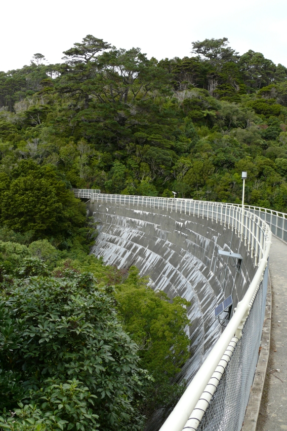
The concrete used in the dam construction was made with Portland cement, and was poured in a series of horizontal layers, which are visible on the downstream face of the dam. In order to link each layer of concrete to the next, ‘spalls' ‘selected rocks no more than 12 inches in any direction' were beaten into each layer with their tops protruding. This acted as a ‘key' onto which the next layer of concrete was joined.
Offer explains how concrete was utilized in the dam's construction:
The inner ‘core' of the dam consists of concrete made with a coarse aggregate probably from a quarry on the left abutment of the dam. This core was encased in a skin of higher strength concrete made with a clean river gravel aggregate and placed separately against the core concrete. This feature has something in common with a similar form of construction in modern concrete gravity dams which in higher quality concrete is placed to form the faces of the dam. However, the modern technique is to place both concretes together.
A report by engineers Beca, Carter, Hollings and Ferner noted that the original drawings for the Upper Kaori Dam show some ‘as constructed notes':
These indicate that the dam foundations were excavated to a greater depth than was originally required by the drawings. This suggests that either poor quality rock was found or that the shatter zone along the Wellington Fault was encountered and had to be excavated to firm material. The drawings also show the original stream and ground levels and these can be compared with the present ground levels to indicate the amount of backfill placed.
Similarly, while the spillway would be constructed on the dam's right abutment, the plans show that the spillway was originally going to be built on the left abutment.
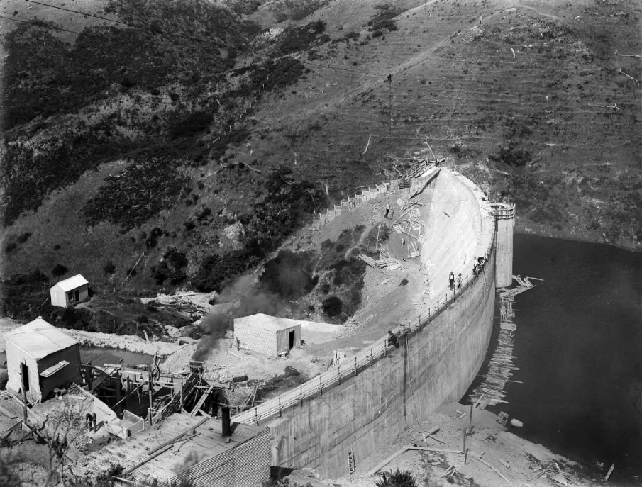
Further information on the construction of the dam comes from research done by Alison For, who completed a heritage inventory on the Karori Wildlife Sanctuary in 2002, and the Combined Rotary Clubs of Wellington for the Wellington Rotary Centennial Karori Wildlife Sanctuary Discovery Project in 2004. Both drew on material such as historic photographs, original contracts and plans. Historic photographs for example show the tramway that was used to transport materials to the top of the dam, the line of which can still be seen when following the Lake Road through the Sanctuary. Another historic photograph suggests that the clearing below the Upper Dam, which consists of tunnels, pipes, races and surge tanks from the dam and the main valve shut off for the dam, was likely the lower level construction area and that a terraced area above the finished level of the dam was used as the upper level construction area.
The Combined Rotary Clubs of Wellington also drew together information on the construction of other dams, such as the Wainuiomata (Morton) Dam, to add to what they knew about the construction of the upper dam. Based on this information, as described on the interpretation panels around the Upper Dam, a system of cables, supported by a 1012m timber tower, would have been vital to the dam's construction. They suggest this tower would have dominated the upper construction area in the year 1907. In order to accommodate the curve of the dam face, the tower would have been mounted on four bogies (wheels), and winched along two parallel pairs of heavygauge rails; to date, three of the bogies have been found in the Sanctuary. A hopper (a funnel shaped bin) would then have moved along the cableway reaching across the valley, and poured concrete where required along the radius of the dam. The area the tower moved along had to be level, and it has been suggested that this was done by hand with picks and shovels.
In other interpretation panels the Combined Rotary Clubs of Wellington describe how water collected at a rock dam, the remains of which can still be seen, passed through a system of pipes to be used for a variety of functions in the construction of the upper dam. They note that water was needed for washing aggregate, batching concrete, to power steamdriven machinery and providing drinking water for the workers especially ‘cups of tea'. They also discuss how corrugated iron and timber sheds were erected, most probably to store coal and tools and to provide shelter for the workmen. Some evidence of these building sites can still be seen in the excavations at the rear of the construction area (the Sanctuary has placed a replica hut near the existing hut sites, which are situated on the Campbell Street Track). A partially collapsed corrugated iron shed also exists near the top of the upper dam (below where the Campbell Street Hut sites are situated). Alison For points out that this hut may have been used in the construction of the dam as the tender for the Upper Dam specifies the construction of two huts, a shed for mixing and storage of cement and an office for clerk of workers.
By 1908 the Upper Karori Dam was complete, and on March 12 1908 it was taken over from the contractors by the Wellington City Council.
The Upper Karori Dam was constructed to stored 266 million litres (59 million gallons), with 177.2m (581.4 ft) of top water. Years later however, the dam which had itself been built to supplement an insufficient supply could not keep up with Wellington's demand for water. In 1943 a report showed a deficiency in Wellington's water supply, causing a depletion of the upper reservoir, which had been ‘called upon to make up the balance.' Consequently, in 1945 the upper reservoir was supplemented by water uplifted by pumps 120m from Long Gully, a branch of the South Karori Stream. This supply was discontinued in 1956 when the Hutt River source was brought into Karori. With such developments, the function of the Upper Karori reservoir altered: from a water supply reservoir to a reserve reservoir to be used when other sources are unavailable, for example when supplies from the Hutt River become turbid and unusable in floods. The ‘useable storage' was estimated in 1975 as 200 million litres (44 million gallons).
In 1978, a safety appraisal was undertaken by consulting engineers Beca Carter Hollings and Ferner. In order to review its stability, water pressures were measured under the dam and were found to be significant enough to pose risk. Dam designers at the time did not account for the significance of water pressure under a dam which arises from lake water seeping through the bedrock. Indeed, the need to consider this factor was only slowly being recognised throughout the world.
Further investigation revealed that the curve of the dam in fact only contributed a small amount to its stability, and this was insufficient to protect the dam against the force of an earthquake. This means that while it is indeed curved to have the appearance of an arch dam, which Offer says was a common practice at the time, only a small contribution to the stability of the dam arises from the arch effect. The dam's position is particularly precarious considering its (unbeknown at the time of construction) positioning across the Wellington fault.
According to the Beca Carter Hollings and Ferner report, despite the earthquake risk, the dam was generally in ‘sound condition' with the exception of the spillway. The report noted that ‘the spillway chute downstream of the crest' was in ‘very poor condition' with severe damage possible if ‘large spillway flows occurred'. The higher strength concrete on the surface had broken away in places exposing the low strength concrete beneath while the timber spillway chute had completely collapsed causing water to bypass the concrete stilling basin. The report recommended that the spillway be repaired by ‘replacing the defective concrete' and reconstructing the collapsed timber chute. Plans from 1980 indicate that the timber portion of the spillway was subsequently reconstructed and it seems likely the minor repair work to the concrete took place at this time. As far as John Fraser (reservoir caretaker from 1960 to 1997) is aware, no major maintenance work was carried out on either of the dams during the time he was there: the original pipes were cast iron and were replaced in 1962 because of rust barnacles inside them, but no further detail given. Therefore, from the information available, it appears that the dam has remained virtually unaltered from the time of its construction.
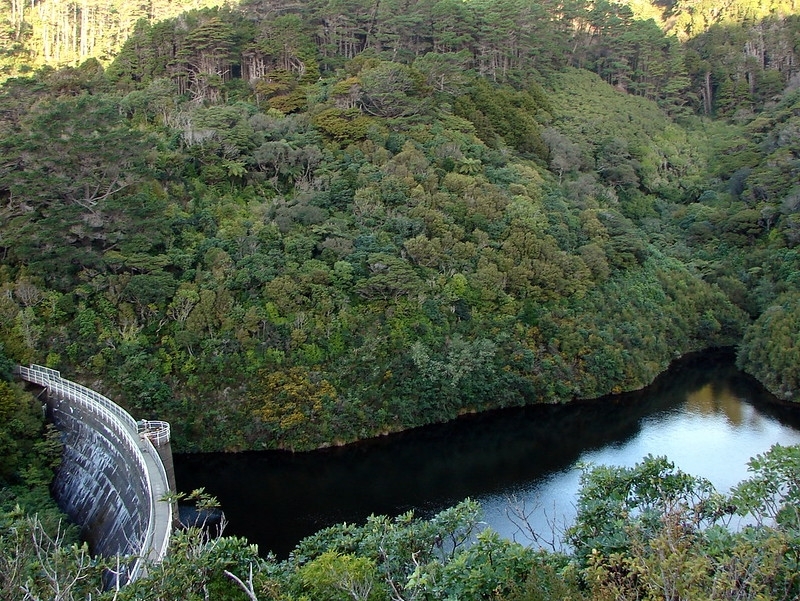
In 1992 the Upper Karori Dam was partially emptied due to earthquake risk following the commissioning of the Ngauranga Water Supply Pumping Station. Thus the water level behind the lake was lowered, and today there is an obvious change in the vegetation above the lake which illustrates its previous height. After the Upper Karori Dam was partially emptied and no longer used as part of Wellington's water supply, efforts to keep people out of the area were reduced. However, with the commencement of the Karori Wildlife Sanctuary development in 1993, public access to the valley was restricted until 2002 when the Sanctuary opened seven days per week.
In 2004 the Sanctuary opened the ‘Discovery Area,' in which the Upper Dam construction area was developed and interpreted for the public. The Sanctuary developed the Discovery Area with the Combined Rotary Clubs of Wellington. The project served to commemorate Rotary's centenary, which took place in February 2005. Several reconstructed features (reconstructed cable tower/lookout and hut, replica skip and new tracks through the bush) and interpretation signage explaining both original and reconstructed features, were installed.
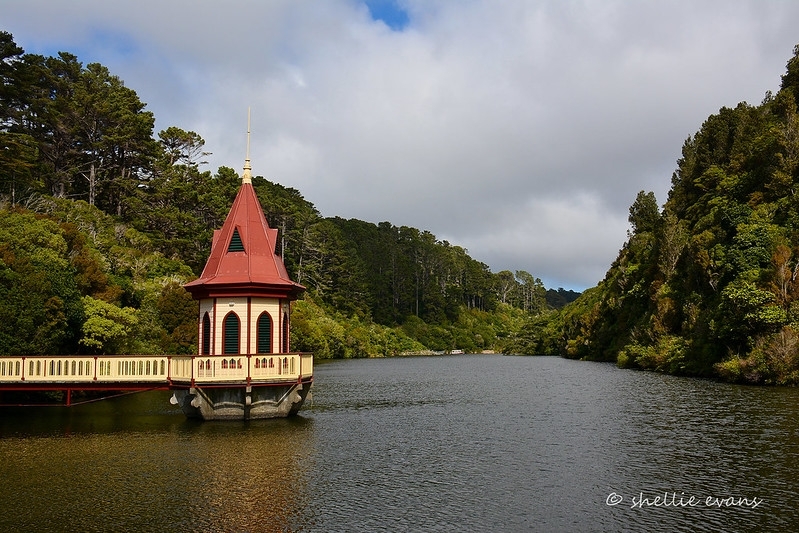
Other changes in the Upper Karori Dam area include the addition of a pair of binoculars, a wooden platform and movable steps atop of the builtin valve tower in the middle of the top of the dam. These were added by the Sanctuary in 2004 to allow people of varying heights to better view the water fowl in the reservoir below. Other modern equipment has been fitted to the handrail of the barrier that runs along the top of the dam. This equipment includes a telemetered water level recorder and solar panel fitted by Capacity; a rain gauge added by Greater Wellington in approximately 2006, and a wind meter and solar gauge added by NIWA at the request of the Sanctuary in 2007. In 2006 Capacity designed and fitted a protective cap to the normal overflow pipe intake in the upper reservoir to overcome debris blocking the pipe.