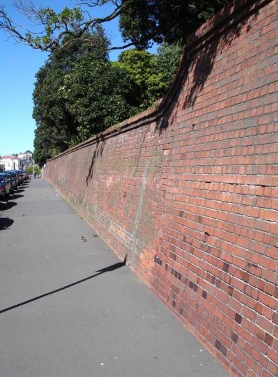
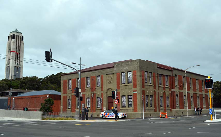
Tasman Street Brick Wall is part of a wider assemblage of buildings and structures that occupy what was once Mt Cook Reserve. The brick wall was built by prisoners in three parts (c.1891, 1893/94 and c.1903) and is today the oldest structure associated with the Reserve.
MOUNT COOK RESERVE:
The Tasman Street Wall retains the eastern base of Mount Cook Reserve, an area described by Premier Richard Seddon as 'the noblest site in Wellington.'
Mt Cook is the European name for a hill, Pukeahu, which was the site of a pa, long abandoned by the time of European settlement. It was renamed by settlers after Captain James Cook. The New Zealand Company saw a military use for it, as the Company's 1840 map shows the hill reserved for military purposes. British troops were stationed there temporarily in 1843 to protect Wellington from potentially hostile Maori in the wake of the Wairau 'Massacre'. Governor Grey reserved the land for military purposes in 1850. After the troops left in 1865 the barracks housed immigrants. In 1879 the building was demolished, more levelling took place and a huge goal was built by prisoners from the nearby Terrace Gaol, using bricks made on site at Mt Cook. Only one wing of the six planned was built (c 1882) and the prison finally closed by 1900. During this period the prisoners working the Mt Cook brickworks made millions of bricks for government and private construction.
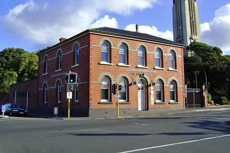
The prison building was taken over by the Army for use as barracks and it was not until 1930 that it was finally demolished. In 1893/94, the Mount Cook Police Station was built on the north-eastern corner of the reserve, at the junction of Buckle and Tasman Streets. The Station and wall are today the oldest structures associated with the Mt Cook Reserve.
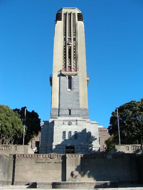
In 1924 the Government decided to build a new museum on Mt Cook to replace the overcrowded Colonial Museum, near Parliament. In 1928 it was decided to combine the museum with the National Art Gallery and build the National War Memorial on the same site. The Carillon, part of the National War Memorial, opened in 1932, despite not being completed. The Hall of Memories was finally built in 1964.
Construction of the Dominion Museum (later National Museum) began in 1932 and officially opened in August 1936. The museum was closed during World War II and used a military headquarters. It did not reopen until 1949. A network of underground emergency shelter tunnels was built in the reserve in 1942. Steps cut into the Tasman Street Wall date from this work and were access ways to the tunnels.
In 1996 the National Museum closed preparatory to a move to the new Museum of New Zealand - Te Papa - on Wellington's waterfront. This took place in 1998, and in 1999 the old Museum was purchased by the Wellington Tenths Trust. Massey University merged with the Wellington Polytechnic and took over the old building, which reopened in 2001 after considerable restoration and refurbishment.
LATE NINETEENTH CENTURY BRICK-MAKING:
Tasman Street Wall is primarily associated with the Reserve's penal and brick-making past. The distinctive prison bricks used in construction of the wall and also the Mount Cook Police Station/Barracks can be identified by their incised broad arrow. The arrow denoted property of the Crown, and was first used in Britain in the 17th century. It became the standard mark of government property, but only became widely used on prison garb in the 1870s. Its adoption in New Zealand was a natural extension of British practices. Use of the arrow was discontinued in Britain in the 1920s.
The bricks were made on site at the prison industry workshop and kiln at Mount Cook Reserve from the late 1870s onwards. The suitability and easy availability of its clay made Mt Cook the centre of Wellington brick-making in the late 19th and early 20th centuries. There were a number of brick-making businesses in the area, particularly on Taranaki Street, Adelaide Road and Wallace Street, but the Mount Cook Gaol was the most important enterprise of all.
The brickworks at Mt Cook Reserve had several advantages over its competitors in the area. The most obvious was the readily available, cheap work force, in the form of hard labour and penal servitude prisoners. Also, by 1884, the bricks were being fired in a Hoffmann kiln, at the time one of only two operational in Wellington.
The Hoffmann kiln was patented by Frederich Hoffmann in 1856 and was revolutionary because it enabled continuous production. As a result it offered further advantage to the Mt Cook Gaol as traditional kilns could only fire one batch of bricks at one time. This meant that production was not only slower, but the process also used more fuel as the kiln had to be reignited after each firing, making this method less economical than Hoffmann's new kiln design. The continuous production of the Hoffmann kilns, like the large one at Mt Cook, was the result of its special features, including a series of compartments which could be loaded externally and firing operating on rotation. The latter meant that at any time the kiln could contain 'green' bricks, bricks which were drying out in preparation for firing, bricks being fired, bricks which were cooling, and completed bricks which were being emptied from the kiln. As a result, Hoffmann kilns increased production and manufactured bricks that were generally of a higher quality than other methods.
By the mid-1880s the Mount Cook Reserve Hoffmann kiln could produce approximately two million bricks per annum, with prisoners from The Terrace Gaol marching to the site each day to provide the necessary manual labour. In 1885, Arthur Hume, the Inspector of Prisons, reported that:
Various tests of the quality of these bricks have been made by competent official authority, which has pronounced them superior to anything of the kind previously produced by private enterprise.
He continued in this vein in 1887 by proclaiming that the bricks were 'universally admitted to be the best ever manufactured in the colony.'
The clay was taken largely from the south-western face of Mt Cook, which eventually created what are today Wellington High School's playing fields. Production at the site continued despite the prison being officially closed in 1900 and eventually re-designated as the Alexandra Barracks. Brick production gradually diminished to the point that in 1918 it was estimated that only 820,000 bricks would be manufactured that year and that the clay supply would soon be exhausted. It was suggested that clay could be excavated from the bank behind the Tasman Street Wall. However, this was halted by the Wellington City Council District Engineer, who wanted the bank to maintain its form as part of an 'improvement scheme' which was to be undertaken on the Tasman Street frontage. It is assumed that the kiln was demolished in 1920, at the same time the old prison was pulled down.
Three significant structures at Mt Cook were constructed from prison bricks: the Mt Cook Gaol (later Alexandra Barracks), the Mt Cook Police Station (Register no. 1408) and the Tasman Street Wall. Other buildings in Wellington which were made from the Mount Cook prison bricks included the Parliamentary Library (Register No 217), the Wellington Harbour Board Wharf Office Building (Register No 1446), Wellington Public Hospital (now demolished), the Government Print Office, and the fortifications at Fort Ballance (Register No 5074). Bricks were also supplied for projects such as the Wellington and Manawatu Railway, as well as to private companies on occasion.
TASMAN STREET WALL:
Despite the kiln's large output, completion of some projects in the immediate vicinity, namely the new Mount Cook Gaol and the Tasman Street Wall, were stalled for years, and in the case of the gaol, were never completed. As noted, the Mount Cook Gaol was begun c.1882 but only one wing was built. Shortage of funds and using prison labour prevented it being built quickly (it was reported as only being up to the second-storey of one wing by 1888). Construction was finally abandoned in 1897. The construction delays caused much frustration for Hume who consistently stressed the need for his new gaol to alleviate the woeful conditions at The Terrace Gaol. The Tasman Street Wall was identified as first appearing on a plan in 1891 in an incomplete state and remained this way until at least 1897 when, in response to lobbying from Mt Cook residents, the city council approached the government urging them to complete the project. It seems likely that the government responded to this request in due course, as the Engineer-in-Chief Public Works Department reported the retaining wall on Tasman Street as completed in 1899.
The delays that these projects faced appear to have been due to demand for prison bricks and labour elsewhere. In the last decades of the 19th century the government placed particular importance on fortification projects in light of the perceived Russian threat, which diverted resources and resulted in the building of structures like that at Fort Ballance.22 Also, the immediate completion of the Tasman Street Wall may have been affected by the fact that in 1891, by the time the first section was completed, production of the prison bricks stopped. The reasons cited for this cessation were increased fuel costs and labour troubles, however, these issues were resolved and production had resumed by the next year. A typhoid epidemic in 1892, which cleared the Mt Cook site, no doubt further slowed construction progress. As a result of this epidemic, further effort was diverted into completing drainage works at the barracks and prison building.
No designer has been identified for the wall although the Mt Cook Police Station was designed by Bryen Weyburne, inspector of works at Mount Cook Gaol. It is possible that he was also responsible for the design of at least the first section of the wall, which predated the building. The construction work was completed by prison labour, which would have been supervised by the prison overseer. No pre-construction plans have been found for the wall, possibly because its construction was considered a fairly prosaic matter. There were various construction periods, including (by) 1891, 1893/94 and (by) 1899. In 1896 a dozen free labourers were also employed to work on the wall from 2 March-6 May, at the same time as working on the approach road to the prison.
The bricks were made on site at Mt Cook from local clay, which would have been ground into a fine mixture before being mixed with water and formed by a mould into the familiar brick form. Many of the bricks show evidence that they were partly formed from crushed and reused older bricks i.e. there are chunks of old brick lying within the fired brick. In addition, brick historian Gary Tonks has identified that the surface of some of the bricks shows the finger impressions of the men who handled the bricks when moist, prior to firing.
The topography of the land the wall retained was much different from what it is today. The land behind the wall was once much steeper in places. A photograph taken in 1926 shows a bank rising directly behind the wall not far from the Rugby Street intersection (see Appendix 2, Figure 6). Today there is a wide platform behind the wall, probably formed when the excavations were made for air raid shelters in 1942 (see below).
In the century since the wall's completion, there have been no alterations to the form of the earlier portion of the wall. However, changing uses of Mt Cook Reserve have led to additions and modifications to the later section. In some cases it is difficult to fix the date of these changes.
Today, a set of stairs and path leave the wall and heads in a south-westerly direction to the top of the hill (see Appendix 2, Figure 16). There was originally a road in this vicinity, formed in the 1840s, and it provided access from the hilltop to a magazine (c.1847) halfway down the hill (where a prefab building stands today) and then on to Banks Terrace (as Tasman Street was once known). It is likely that the path was formed across the reserve to provide access from Tasman Street to the Wellington Technical College, which moved to Mt Cook in 1922. It is possible that access was provided to the path from Tasman Street from the time the wall was completed around the turn of the 19th century, but it is more likely to date from the mid-1920s. A clue to its origins is that the stair is lined with red bricks (and well constructed) but not prison-made i.e. there are no arrows on them. Also, part way up the stairs are cavities in the brick wall (two on the north side and one on the south) that were almost certainly used to house fixings for a gate (see Appendix 2, Figure17).
Some time in the early 1940s Wellington Technical College built tennis courts on the land to the immediate south of the path. It appears as if the path was simply used as a convenient boundary. The site was not level, but rather than cut down the bank below the existing level of the Tasman Street Wall, the land was built up to form a uniform height for the two courts. The fill for this may have come from excavations into the hill to form the courts. As a result, additional courses of brickwork were added to the top of the existing prison brick wall to retain the north court (see Appendix 2, Figure 20). It is possible that the concrete wall on the southern boundary of the reserve (the northern boundary of 60 Tasman St) was formed at this time to retain the fill (see Appendix 2, Figure 20).
In 1942, with the Japanese threat at its highest, air raid shelters were built in many parts of Wellington, including the grounds of Dominion Museum. Four shelters were built on the eastern side of the Mt Cook, just above the Tasman Street Wall. To gain access to the shelters, steps were cut from Tasman Street, about halfway down the wall's length (see Appendix 2, Figure 13). These steps later provided another access point to the museum, and more recently the Massey University campus.
The next significant modification to the form of the wall was the construction of a substation for the WCC's Municipal Electricity Department in 1969. Land was purchased from the Crown for the purpose, at a cost of £227, in November 1968, although Wellington High School did object to the taking of its land when the proposal was first raised in 1965. Positioned to the immediate south of the c.1924 steps, the substation is set into the side of the hill and as such, a portion of the prison brick wall had to be removed to make room for it (see Appendix 2, Fig.18). A new path to the tennis courts was also formed, leading to the entrance gate immediately perpendicular to the top of the wall (see Appendix 2, Fig.1).
In 1978, the Wellington Regional Committee of the Historic Places Trust became involved in the restoration and refurbishment of the Mt Cook Police Station. During this work, considerable interest was focussed on the prison bricks used to construct the building. The Tasman Street Wall, seen as an adjunct of the Station, also received some attention at the time.
However, it was not until 1995 that the wall's heritage value was formally recognised when it was included as an object on the Wellington City Council's District Plan.
Part of the site is now half-owned by Massey University with the Wellington Tenths Trust, who lease the remainder back to the University. The Trust purchased the site in 1997 with the proceeds of their successful Treaty of Waitangi claim and an undisclosed half was on sold to Massey University. The remainder of the site was reserved by the Crown for secondary school purposes and is occupied by Wellington High School, except for the portion of the wall that is occupied by the substation which is owned by Vector Limited. This area, which encompasses the Tasman Street Wall, the Mount Cook Police Station (Register No 1408), National War Memorial and Carillion (Register No 1410), and former National Art Gallery and Dominion Museum building (Massey University, Register No 1409), is now recognised as a heritage precinct under the Wellington City District Plan and is subject to special controls and regulations.
In 2004, sections of cement mortar on the wall were painted (apparently by Massey University students on an assignment). In recent years, the wall has also been vandalised by taggers. One section of badly tagged wall, between the two sets of stairs, was sand blasted in 2006 under the direction of Massey University. Unfortunately, this stripped the bricks of their glazed patina. Tagging remains over much of the southern end of wall, the portion owned by Wellington High School.