Maori occupation
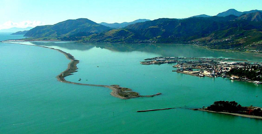
There are a number of Maori legends which seek to explain the origins of the Boulder Bank. A well-known one is the legend of Te Taero a Kereopa. According to this, Kereopa escaped the wrath of Kupe by paddling towards Nelson’s shore while Kupe’s waka was held offshore by a growing barrier of boulders. This is the reason why the Bank is known to some as Te Taero a Kereopa.
Some traditions and legends put forward that Maori were present in the Nelson (Wakatu) area from as long ago as around 850.
The Waitangi Tribunal reports that the Maori iwi and hapu of Te Tau Ihu (top of the South Island) have described their identity in the following terms: ‘Rangitane, Ngati Apa, and Ngati Kuia are descendants of the captain and crew of the.Kurahaupo waka. They were the tangata whenua of Te Tau Ihu in the 1820s and 1830s, when Kawhia–Taranaki tribes migrated to the district. Ngati Toa Rangatira, Ngati Rarua, Ngati Koata, Ngati Tama, and Te Atiawa migrated to.Te Tau Ihu in the 1820s and 1830s from their original rohe in the Kawhia and Taranaki districts. Some have affiliations to the Tainui waka, others to the Tokomaru waka. Ngati Koata settled as a result of a tuku [gift of land] from Tutepourangi, an ariki of the Kurahaupo tribes. The other northern iwi migrated after a series of battles and victories, and set¬tled alongside Ngati Koata and the defeated Kurahaupo peoples. There has been intermarriage between all eight iwi, and they are bound together by whakapapa, co-residence, and overlapping customary rights.’
New Zealand Archaeological Association records in 2007 identified seven pre-European archaeological sites located on the Boulder Bank between Haulashore Island and the Glen. These identified mostly small midden/pits which were distributed along the northern half of the Bank, as well as one midden site on Haulashore Island and two settlement sites at the Glen. A 2010 field inspection identified two new sites on Haulashore Island and also re-recorded one of the midden sites at the northern end of the Boulder Bank as four separate sites given the distance between each archaeological deposit.
The archaeological remains confirm that Maori used the Boulder Bank and its environs as a seasonal base for food gathering during summer. Fresh water was available at the Glen and land for cultivation. The adjacent coastal forest, estuary and wetlands were rich in food and other resources (e.g. flax). The Boulder Bank itself also provided a source of birds and birds’ eggs. Ngati Rarua from Motueka had an encampment at the southern end of the Boulder Bank on what is now Haulashore Island. Coastal land at Wakapuaka was inhabited, possibly including a village (named Koi-te-Hihi or similar). The archaeological remains also confirm that Maori settlement of the Nelson Boulder Bank was early and ongoing.
The Waitaha are said to have established the large argillite (pakohe) quarries dotted along the eastern ranges of Nelson. Over the generations, Maori have carried boulders (some up to 60kg) from the Boulder Bank up to these argillite quarries. The Bank boulders were used as hammers to smash slabs of rock from solid outcrops two metres or more high. Smaller hammerstones were then used to reduce chunks of argillite to adze-sized pieces. Both slabs that were partly worked and finished products were traded around New Zealand.
Eight iwi hold mana whenua status in the Nelson area - Ngati Apa, Rangitane, Ngati Kuia, Ngati Toa Rangatira, Ngati Rarua, Ngati Tama, Te Atiawa, and Ngati Koata. Maori continue to have an ongoing relationship with the Boulder Bank.
European discovery
Although many of the noted early European explorers visited the top of the South Island, only Dumont D’Urville visited Tasman Bay. However, it was not until 1841 that a boating party associated with the preliminary expedition of the New Zealand’s Company’s ‘Second Colony’ discovered the Boulder Bank.
The expedition, led by Captain Arthur Wakefield, included the barques Whitby and Will Watch and the store ship Arrow. When these vessels departed Britain, arrangements were already underway for the first contingent of ships laden with emigrants to promptly follow. At this point it had been established that the main town of the new colony would be named Nelson, but it had not been determined where in New Zealand it would be located.
When the expedition arrived in Wellington Governor Hobson offered land in the North Island, however Captain Arthur Wakefield and his brother Colonel William Wakefield strongly favoured the Canterbury area. Hobson was adamant the South Island was not available until other land claims had first been resolved. With this stalemate, the Wakefields looked for a site within the lower North Island and upper South Island, land Colonel Wakefield had negotiated over in 1839 with local Maori chiefs.
Captain Frederick Moore of Wellington was familiar with Tasman Bay and piloted the expedition ships to explore it. Captain Wakefield initially assessed the area around Motueka and tentatively decided on a site for the settlement between Motueka and Riwaka. However, after sending a small exploratory party over to the eastern side of the bay, the discovery of the Boulder Bank and the sheltered water body behind it provided Captain Wakefield with a potential new site.
He sailed his three ships into the harbour behind the Boulder Bank, and, after assessing both the harbour and its surrounding land, quickly determined that the settlement of Nelson would be built on its shores - ‘a haven full of birds, fish, fresh water and plenty of wood for building’. The harbour was subsequently named Nelson Haven.
Arrow/Fifeshire Rock
The first settlers to Nelson Haven arrived in February 1842 on board the Lloyds, Fifeshire, Mary Ann and Lord Auckland. It was to be the last journey for the Fifeshire. On her departure from Nelson Haven, a falling tide and failing wind conspired to ground her cast on the reef surrounding Arrow Rock and becoming a total loss. After this event Arrow Rock commonly became known as Fifeshire Rock.
The Fifeshire was by no means alone in having the misfortune to run aground near the southern end of the Boulder Bank. Many vessels foundered here, partly because of the narrow and shallow harbour entrance between the Boulder Bank and Arrow/Fifeshire Rock. This passage was known as ‘the Narrows’. In all, there are at least 19 shipwrecks and 5 hulks scattered around the Nelson harbour and entrance, with the wrecks of at least ten vessels known to have occurred within the historic area.
Haulashore Island (formerly Fifeshire Island)
This ‘island’ is located at the extreme southern end of the Boulder Bank. At high tides, it and a nearby elevation (later named Magazine Island) were cut off from the rest of the Boulder Bank, and the water passages in between were deep enough for small vessels to use. At all other tides, these two islands formed a continuous part of the Bank.
Captain Wakefield named Aglionby Point at the southern end of Haulashore Island after one of the New Zealand Company’s directors, Henry Aglionby, M.P. Aglionby Point is also the site of the first known Pakeha burial in Nelson, which took place in November 1841. Thomas Cresswell, one of the New Zealand Company’s men, was buried there after succumbing to typhoid. A memorial plaque has been erected on the island by his descendants.
When Nelson was formally subdivided into land titles in 1842, three town acres on the Island were offered for sale. A fourth town acre was selected by Magistrate H. A. Thompson as a native reserve. Three locations on the perimeter of the island were set aside as defence reserves. These were named after the endeavours of Admiral Nelson.
In the first years of European settlement Haulashore Island was also used as a holding paddock for stock. The Posthumous from Australia, for example, in 1843, disembarked part of her cargo of 1600 sheep on this island. Some vessels pulled into Nelson Harbour as a result of the inclement weather, discharged their stock in Nelson and then had it driven overland to developing sheep runs in Marlborough and Canterbury.
Haulashore Island was initially called Fifeshire Island, because the Fifeshire was wrecked adjacent to it. However, during the late nineteenth century the use of the name of ‘Haul-ashore’ for the island became widespread. This was because the island was eminently suitable as a place for ‘hauling ashore’ vessels for repair and refurbishment and a large number of vessels used this facility. The use of Haulashore Island as a natural slipway started to decline with the development of alternative facilities on the mainland. As late as 1934 the coastal paddle steamer Lady Barkly was beached there to be dismantled. The Lady Barkly (built in 1861) was then thought to be the oldest steamship in the southern hemisphere, and had been armour-plated and used in the advance guard for steamers on the Waikato River during the New Zealand Wars. Haulashore Island continued to be used for occasional repair and maintenance work on vessels into the 1960s.
In 1906 Haulashore Island became a permanent island when it was severed from the Boulder Bank when a shipping channel was dredged through. The dredged channel is known locally as ‘the Cut’. The island effectively doubled in size as a direct result of the dumping of dredge spoil from the excavation activities.
The Nelson Iron Duke Sea Scout Group has long had an association with Haulashore Island. They often held camps on the island and in the 1920s began a planting programme there - possibly in an attempt to break the southerly winds that could sweep the island, thereby giving more sheltered water for their marine activities in the Haven, and also as a future source of firewood for fundraising drives. Other planting efforts were also made and Captain Malcolm and Perrine Moncrieff gifted a portion of the island to the Nelson City Council for the special purpose of a playground for the children of Nelson. Perrine Moncrieff was a key driving force in the establishment of the Abel Tasman National Park.
New harbour entrance (the Cut)
Nelson’s port became increasingly important very soon after organised immigration began. From 1842 to 1847 Nelson’s overseas arrivals exceeded those of the ports of both Auckland and Wellington and it continued to hold its own against these ports for at least another decade.
The entrance to Nelson harbour required care and knowledge of the tides to ensure a safe passage between Arrow/Fifeshire Rock and Haulashore Island. From 1842, vessels waiting for the right conditions used a natural deepwater basin 760 metres to the west of the entrance, known as Bolton Hole (also Bolton Deep or Bolton Roads), as an anchorage. The natural constraints of the harbour entry point were compounded when the eastern outlet of the Waimea River started to change its course. Corresponding changes in the location of the sandbar near the harbour entrance and shallowing water caused headaches for the settlement’s marine engineers in the 1870s-80s. Steamers ran aground and sailing ships would touch the bottom when coming through the Narrows.
Efforts to improve the harbour passage by blasting adjacent to Arrow/Fifeshire Rock did not provide a workable remedy. The most likely solution was to cut a new passage right through the Boulder Bank, but there was no consensus on where the ‘Cut’ should go. A vigorous debate dragged out over the next decade. Eventually a modified version of a plan by Leslie Reynolds was adopted in 1899 by the Nelson City Council. The projected cost of dredging a channel 4.6 metres deep and 152 metres wide, plus associated works, was £58,000. Work finally began on the Cut in 1903.
The pressure to have the Cut operational as soon as possible was intense. It was officially opened in 1906 when its bottom width was only 60 metres, less than half that planned. However, the new passage that the Cut provided to shipping did not stop the controversy over its inadequacy. Dredging efforts continued but it wasn’t until 1969 that the width and depth of the Cut initially envisaged in 1906 was finally reached. As a part of the dredging operations, a dragline operation was implemented in the 1960s. Remnants of the bridle structure on Haulashore Island, the wharf and foundations for the winch-house structure associated with this activity remain.
The dredging of the new harbour entrance in 1906 physically severed the Bank. Its effect on shipping access was immediate. The port facilities nestled in Nelson Haven could be more readily and safely accessed, contributing to the economic and population growth of the region, and the settlement of Nelson went from strength to strength.
Magazine Island
Magazine Island, in contrast to Haulashore Island, has over time lost its so-called island status. As the top gravel layer of the Boulder Bank has extended further southwards, it has enveloped Magazine Island. The latter is now indistinguishable from the rest of the Boulder Bank.
Magazine Island acquired its name because of powder magazines which were erected on it from as early as 1843. The remains of the powder magazine erected there in 1874 and substantially dismantled in 1971 can still clearly be seen. The island was also the location of an early iron railing slipway (erected pre-1902), and some evidence of this remains close to the powder magazine.
Nelson lighthouse
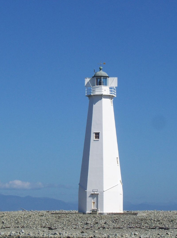
The Boulder Bank is the location of the second permanent lighthouse to be built in New Zealand (1862) and it played an extremely important role in the development of Nelson. The New Zealand Historic Places Trust has registered the lighthouse as a Category 1 historic place (Register no. 41).
In 1888 the flagstaff and tide signal station which stood on Britannia Heights on the mainland were moved to beside the lighthouse tower on the Boulder Bank. In the same year a telephone was installed in the lighthouse and in 1897 it was linked with the country’s telegraphic system. In 1906 the status of the facilities associated with the lighthouse were recorded as follows: ‘The lighthouse is situated on the Boulder Bank, and also the telegraph and signal station, from which the general bar and tide signals are shown, as well as tidal signals indicating the depth of water at the entrance, as shown by the inner tide gauge. The lighthouse has telephone communication with the pilot station; and an efficient pilot service, which is compulsory, has been established.’
The lighthouse was manned from 1862 until 1915, when an unwatched flashing beam was installed. Prior to this the light had been a fixed beam, but this had begun to cause confusion with lights from dwellings on the hills inland. The families of the lighthouse keeper and his assistant were housed in a complex which grew to include two dwellings and a number of outbuildings. John Kidson was a lighthouse keeper of particular note, given he and his family of eventually 10 children lived at the lighthouse for an unbroken period of 27 years until 1892. Once the lighthouse became automated the families moved off the Boulder Bank and the buildings were soon dismantled and moved off-site. The signal station was also removed.
The lighthouse and a small area of land around it are now in the ownership of Port Nelson Limited.
The Boulder Bank baches and recreation on the Boulder Bank
Historical accounts are scanty but suggest nine baches have existed on the Boulder Bank. Only six of these remain today. Of these, four are very old and likely started life as basic overnight shelters for fishermen who used to tar their fishing nets on the Boulder Bank and leave them out to dry.
All of the baches have contributed to a social history of the occupation of the Boulder Bank, notably with Bill Clark living permanently in his bach for around 37 years from the 1950s. Typically, past owners used their baches on an intermittent basis only but, irrespective of this, a healthy community spirit built up over the years. This spirit has carried through and present bach owners regularly get together for social gatherings, particularly around Christmas time. The old baches, along with the two more recent baches constructed in the 1950s, continue to form the background for ongoing social interaction among the owners. Elections for a mayor and councillors of their own little ‘municipality’, which has its own flag, have been a feature in some New Year celebrations among bach owners.
Historically the Bank has been used for recreation from the early years of the European establishment of Nelson. Activities tended to be concentrated at either end of the Bank. For instance, one could travel out to The Glen at the northern end aboard a horse-drawn charabanc, followed by a paddle in the water then afternoon tea at the Edmondson’s tearooms located next to the Boulder Bank. At the city end of the Bank, Haulashore Island was the scene of organised events, such as Children’s Day in 1918 when a maypole and tents were erected.
A wide variety of recreational pursuits are enjoyed by the public at large on the Boulder Bank to the present day. A ferry service provides on-demand transport to and from Haulashore Island, the Boulder Bank and the mainland. While it is possible to camp overnight on Haulashore Island, visitors are typically day-trippers. Haulashore Island is very popular for picnicking and children’s (pirates) parties, and the Department of Conservation, as well as the Nelson City Council and Tasman District Council, often hold activities there, such as Conservation Day or school holiday events. The Boulder Bank is very popular for those who enjoy walking, beachcombing and fishing. Snapper Point, towards the northern end of the Boulder Bank, provides one of the most reliable locations in the Nelson/Tasman area for good surfing. Organised multi-sport events are also held on the Bank, for example the Nelson Ironman, which is run every summer.
In 2010 an inaugural Boulder Bank Challenge run by Rotary provided transport to and from the Bank and saw 300 people take the opportunity to walk eight kilometres of its length and collect rubbish along the way. A similar number took part in the challenge in 2011 and the event is now an annual one.
Mackay Bluff, Wakapuaka & Glenduan
Mackay Bluff is the five kilometre long cliff-face at the northern end of the Boulder Bank which is the source of the boulders for the Bank. At the southern end of the bluff is the small settlement of Glenduan (the Glen).
Mackay Bluff was named after James Mackay senior, a Scotsman who arrived in New Zealand with his family in 1845. Mackay played a major role in draining the swampland immediately adjacent to the Boulder Bank at Wakapuaka, near the Glen. As a part of this drainage system, a pipe through the Bank eventually connected with a siphon system, to allow floodwaters over the Wakapuaka Flats to drain out with the receding tide. These flats are now highly productive farmland.
More recent use of the Boulder Bank
In recent years the number of outfall pipes driven through the Bank has increased. Two pipes located on the Wakapuaka Flats are for stormwater drainage and outfall from the Nelson City sewerage treatment plant, and a third outfall is associated with the Sealord fisheries factory at Port Nelson.
In 1969 a causeway was constructed between the mainland and the Boulder Bank. This facilitated development of the sewerage treatment plant. It also provided a new route for vehicles to access the Boulder Bank, though it has always been prohibited to drive vehicles directly on to it in this location.
An old farm track, around five kilometres long, has been developed at the northern end of the Boulder Bank and provides the only formed vehicle path on the Bank itself. It is the result of an historic easement to allow access by tankers to the adjacent farm milking shed, however the shed now no longer exists. The track was extended a number of years ago to provide access to the Cawthron Aquaculture Centre. The latter (under public pressure) has now formed up an alternative access road, providing the opportunity for the farm track to be permanently closed to vehicles. The track is currently used on an ad-hoc basis for access by campervans, house buses and other vehicles.
The Boulder Bank and its social and scientific importance
The Boulder Bank has a special meaning for the people of Nelson. It is unique in New Zealand, and because of its long length and the large size of its boulders it is in fact the largest of its type in the world. The advocacy of local environmental groups Friends of Nelson Haven & Tasman Bay Inc and Forest & Bird in the 1970s played a great part in raising public awareness of the landform and first campaigned for its protection.
Nelson has since adopted the Boulder Bank as an icon of the city. Arrow/Fifeshire Rock, close to Haulashore Island, is also a very dramatic landscape feature. The views of these landforms from Rocks Road in Nelson are much appreciated by the locals. Between these two landforms lay the original harbour entrance, and this passage is still widely used by recreational marine craft. When the tides are very low, it is nearly possible to walk to the Rock and it is readily swimmable from either Haulashore Island or the mainland. Arrow/Fifeshire Rock and Haulashore Island are both very significant elements in Nelson’s coastal recreational environment. Both landforms are very often portrayed in a wide variety of artwork and media, and publicity and marketing material. Nelson’s first community Access Radio station was initially named ‘Boulder Radio’. Nelson has formed a sister city relationship with Miyazu in Japan, based on the similarities between the Boulder Bank and the reminiscent sandy coastal spit in Miyazu, Ama-no-Hashidate, that is considered to be one of Japan’s ‘Three Great Views’.
Nelsonians are passionate about their coastline and have often voiced their outrage at proposals which may directly adversely affect it, for example when a consortium planned to build a large bulk cargo wharf facility off the Boulder Bank near The Glen in 1994. The facility was to cost $97 million, cater for supercarriers and be called Port Kakariki. It was not built, but its proposal spawned the creation of the Nelson Boulder Bank Action Group.
In a similar vein, public outrage was immediate in April 2008 when a group of intoxicated people paddled over to Arrow/Fifeshire Rock in kayaks and one of them pulled out the lone cabbage tree that was valiantly surviving atop it. Attempts were subsequently made to re-establish a cabbage tree in the same spot.
Public concern about change to these coastal landforms continues in 2012 in relation to a proposal to erect a large-scale sculpture on Haulashore Island. There is widespread and ongoing debate over the scale, design and inherent appropriateness of the proposed multimillion dollar sculpture in this landscape.
Suggestions from the Department of Conservation over the past decade that the baches should be removed from the Bank to return it to its natural state have also met with strong opposition by some within the Nelson community. Many consider the baches represent an integral element of the social history of the Bank, and public interest in the structures on open days is high.
Four-wheel drive vehicles have over many years gained unlawful access onto the Bank to reach fishing spots and to illegally take boulders and driftwood. In the early days of Nelson’s settlement the Nelson Harbour Board and Nelson City Council regularly extracted large quantities of material from the Boulder Bank for a variety of uses. It was particularly sourced as basecourse material for the expanding road and rail network. Boulders were also used for a number of other purposes, including as house piles and kerbstones. However, the wholesale extraction of boulders was prohibited in the 1970s. This has not stopped people from taking boulders for private use, often by the trailer-load. Though the potential for a breach in the Bank is small, the boulders taken are typically from an area where the profile of the Bank is very low and is the place most likely for any breach to occur.
Since the Department of Conservation took over its administration from the Nelson Harbour Board in 1992, the Bank has been a formal scenic reserve. The general doctrines of the Conservation Act 1987 therefore apply. The Nelson Resource Management Plan enunciates the international significance of the Boulder Bank. Its sister plans, such as the Wakatu Heritage Strategy, the Nelson Biodiversity Strategy and the Nelson Community Plan, all articulate the importance of reinforcing a sense of ‘our place’, strengthening Nelson’s identity, safeguarding heritage, and, in the case of the Biodiversity Strategy, specifically identify the Boulder Bank as a flagship site for raising public awareness of the environment.
The international scientific significance of the Boulder Bank has been recognised by the Geological Society of New Zealand, who have identified it as a site of international significance in its Geopreservation Inventory, which also notes its vulnerability. A number of esteemed geological experts also consider the Boulder Bank to be of great scientific importance and a site that offers unique opportunities for scientific advancement because of its rarity and size.