Constructed in 1879 as one of the first buildings to be built in the town of Methven, the modest timber Mount Hutt Road Board Office (Former) at 59 Main Street (State Highway 77) is a relatively rare surviving purpose-built and stand-alone road board building, with a long history of community use. It has historical and cultural significance, both in reflecting the story of New Zealand’s emphasis on road building since colonial times and for the varied public use for meetings, worship, music and recreation throughout its life. The building also has aesthetic, architectural, archaeological and social value.
Mount Hutt Road Board was established as a separate entity in 1879 and tenders were called for an office as well as cottage and stables in Methven. The contractor was Mr Coutts who completed the office quickly, in time for the Board members to hold a meeting in its new hall at the end of 1879.
Fronting close to the western side of Main Street, at the south end of Methven, the Mount Hutt Road Board Office (Former) is a small single storeyed building constructed of timber with a gabled corrugated iron roof. Rectangular in plan, it comprises a main hall, just over ten metres long by five metres wide, with a lean-to entrance lobby on its north side. The interior has timber dado panelling and lath and plaster, and on the south wall is a timber fire surround branded with MHRB markings. A large four panelled timber cupboard is a chattel within the building.
By the time the Mount Hutt Road Board was formed, much of the roading network had already been formed, so a large part of their task was maintenance of the roads and bridges and gathering rates. A range of matters were dealt with from the Mount Hutt Road Board Office building. It served as a polling place, assessment court and general meeting venue. The board also acted as the Domain Board from 1885 until 1922 and during this time they planted many trees around the domain and cemetery in Methven and elsewhere.
After the Mount Hutt Road Board was disestablished in 1939, the building continued to be used by the community, including musical groups such as the Methven Orchestral Society, Methven Choral Society and Methven Caledonian Pipe Band. When the building was threatened with possible demolition in the late 1990s, lobbying by some members of the community led to an eventual decision that the building would be saved through shifting it some 16 metres within the same land parcel and this occurred in 2000.
Mount Hutt Road Board was established as a separate entity in 1879 and tenders were called for an office as well as cottage and stables in Methven. The contractor was Mr Coutts who completed the office quickly, in time for the Board members to hold a meeting in its new hall at the end of 1879.
Fronting close to the western side of Main Street, at the south end of Methven, the Mount Hutt Road Board Office (Former) is a small single storeyed building constructed of timber with a gabled corrugated iron roof. Rectangular in plan, it comprises a main hall, just over ten metres long by five metres wide, with a lean-to entrance lobby on its north side. The interior has timber dado panelling and lath and plaster, and on the south wall is a timber fire surround branded with MHRB markings. A large four panelled timber cupboard is a chattel within the building.
By the time the Mount Hutt Road Board was formed, much of the roading network had already been formed, so a large part of their task was maintenance of the roads and bridges and gathering rates. A range of matters were dealt with from the Mount Hutt Road Board Office building. It served as a polling place, assessment court and general meeting venue. The board also acted as the Domain Board from 1885 until 1922 and during this time they planted many trees around the domain and cemetery in Methven and elsewhere.
After the Mount Hutt Road Board was disestablished in 1939, the building continued to be used by the community, including musical groups such as the Methven Orchestral Society, Methven Choral Society and Methven Caledonian Pipe Band. When the building was threatened with possible demolition in the late 1990s, lobbying by some members of the community led to an eventual decision that the building would be saved through shifting it some 16 metres within the same land parcel and this occurred in 2000.
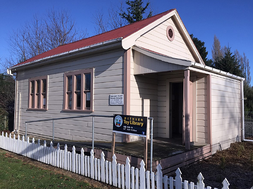
Mount Hutt Road Board Office (Former), Methven. Photo Competition Entrant 2026 | Kirsty-Anne Saxon | 22/02/2026 | Kirsty-Anne Saxon
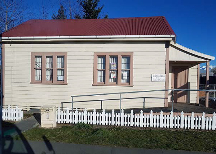
Mount Hutt Road Board Office (Former), Methven | Arlene Baird | 05/06/2019 | Arlene Baird
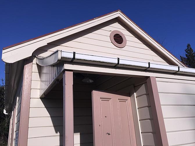
Mount Hutt Road Board Office (Former), Methven. North elevation gable and porch | Arlene Baird | 05/06/2019 | Arlene Baird
Mount Hutt Road Board Office (Former), Methven. Photo Competition Entrant 2026 | Kirsty-Anne Saxon | 22/02/2026 | Kirsty-Anne Saxon
Mount Hutt Road Board Office (Former), Methven | Arlene Baird | 05/06/2019 | Arlene Baird
Mount Hutt Road Board Office (Former), Methven. North elevation gable and porch | Arlene Baird | 05/06/2019 | Arlene Baird