

Māori rock art in New Zealand is known by various names to tangata whenua, such as te tohutohu o neherā, whakairo tawhito and te ana whakairo. Rock art in the North Otago region is treasured as an insight to tangata whenua tūpuna from the times of Rapuwai, Waitaha, Kāti Mamoe and Ngāi Tahu who all travelled through the limestone country and left their mark using complex inks that remains visible today. Rock art is of special significance as an example of some of the earliest evidence of human occupation in New Zealand that remains in situ, and can still be experienced in our landscape. The Awamoko Rock Art Site has special significance to tangata whenua as a physical example of the activities and places associated with their ancestors that still exists in their landscape today. Rock art sites relate to traditional stories associated with settlement and travelling pathways and provide tangible evidence of traditions and practices of Ngāi Tahu ancestors. Although no direct dating of rock art has been carried out in New Zealand, the similarity in style to Eastern Polynesian rock art, the depiction of long extinct birds such as moa and the Haast eagle, and the presence of early period archaeological deposits in shelter floors suggest that rock art was a practice that came with the earliest settlers to Te Wai Pounamu. The Awamoko Rock Art Site contains many whakairo tawhito of great importance to tangata whenua, and the site is special in that it includes examples of rock art with a variety of depicted art, and ink colour.
Location
List Entry Information
Overview
Detailed List Entry
Status
Listed
List Entry Status
Historic Place Category 1
Access
Private/No Public Access
List Number
5670
Date Entered
4th April 1985
Date of Effect
3rd March 2020
City/District Council
Waitaki District
Region
Otago Region
Extent of List Entry
The extent includes part of the land found in Lot 2 Deposited Plan 461559 (RT OT 461559), Otago Land District, and part of the land found in Pt Lot C DP 1385 (RT OT15B/722), Otago Land District. The extent includes the archaeological sites identified in the New Zealand Archaeological Association Site Recording scheme as I41/16, I41/17, I41/18, I41/19, I41/20, I41/21, I41/28, I41/29, I41/30, I41/31, I41/32, I41/33, I41/34, I41/35, I41/36, I41/37, I41/38, I41/39, and includes all land within a 300m radius around each of these recorded sites within these land parcels.
Legal description
Pt Allot C DP 1385 Block II Maerewhenua SD
Location Description
NZTM Grid Reference (additional grid references are available in the physical description) Easting: 1419934 Northing: 5023027
Cultural Significance
Cultural Significance or Value The site is important for a number of cultural reasons. It is primarily important to the Kaitiaki Rūnanga, Te Rūnanga o Moeraki, and to the Ngāi Tahu Whānui as a whole, as a place inhabited by their ancestors in the past, with visible reminders of their occupation still discernible in the landscape. For this reason it is of the highest importance in a cultural sense. This place is a landmark that contributes to the identity of the Ngāi Tahu people, and they remain active guardians of this area. Traditional Significance or Value There are many traditional stories associated with this site that make this area continue to be of special traditional significance to Ngāi Tahu. As physical reminders of their early ancestors, these sites also provide reference to relationships with North Island iwi such as Ngāti Porou in regards to stories associated with the waka Arai-Te-Uru and the ancestor of the Ngāi Tahu people – Tahu Pōtiki, who came from Te Tai Rāwhiti. There are also traditional connections to Waikato iwi and Ngāti Kahungunu, in regards to stories associated with the ancestor Tamatea-Pōkai-Whenua. The surviving rock art found at the Awamoko Rock Art Site are described by Ngāi Tahu as a particular taonga of the area, providing an important and unique record of the lives and activities of their ancestors who travelled throughout the region.
Historic Significance
Historical Significance or Value Māori rock art is a significant surviving part of New Zealand’s earliest human history, and the Awamoko Rock Art Site rock is an important representative example. There is still much that is unknown about rock art sites such as this, and further research has the potential to develop our understanding of important sites of early human settlement in Aotearoa New Zealand. The rock art at this site has been of considerable interest to archaeologists and international scholars since the first half of the twentieth century, and this site provides an area with a rich variety of rock art to study.
Physical Significance
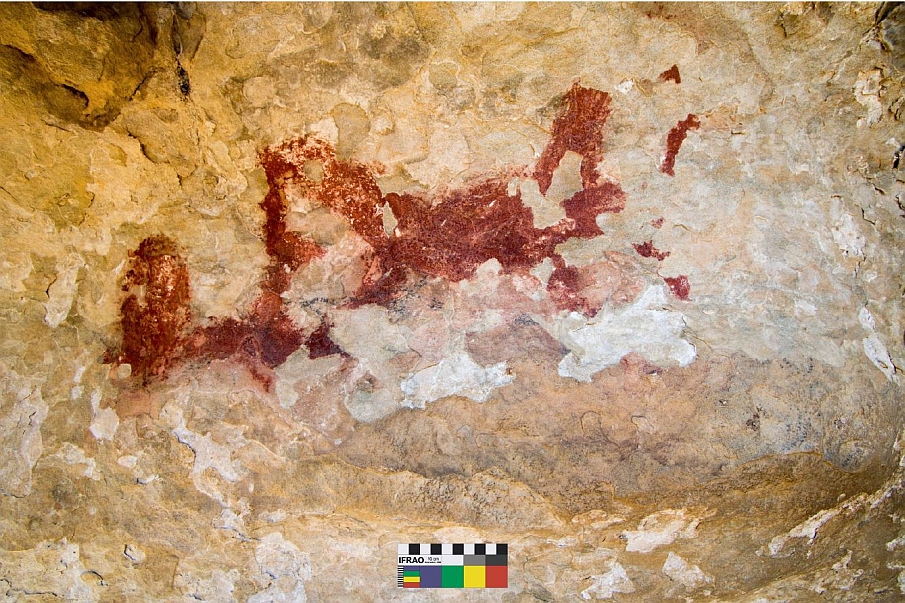
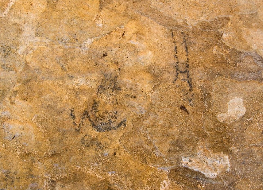
Archaeological Significance or Value The Awamoko Rock Art Site has archaeological value of national significance. The rock art is clearly visible, in good condition, shows a variety of colours, and contains some complete figures. This allows comparisons to be made with the styles and techniques used at other sites. In comparison, many other rock art sites in New Zealand contain only very fragmentary and faint traces of art. The site is valuable in terms of the information gathered through more than 70 years of archaeological research, and has the potential to further contribute to the current body of knowledge relating to the rock art and archaeology in New Zealand. There have been 84 sites recorded in this vicinity by SIMRAP (the South Island Maori Rock Art Project) and these 18 closely located examples of rock art are also recorded in the NZ Archaeological Association Site Recording Scheme.
Detail Of Assessed Criteria
This place was assessed against, and found to qualify under the following criteria: a, b, c, d, i and k. It is considered that this place qualifies as a Category 1 historic place. (a) The extent to which the place reflects important or representative aspects of New Zealand history Māori rock art has been studied by scholars in New Zealand since the earliest recordings of an archaeological nature were being made. Although there are a large number of recorded rock art sites around the country, the Awamoko Rock Art Site is an important representative example with a variety of forms and colour. (b) The association of the place with events, persons, or ideas of importance in New Zealand history Māori rock art is an important and tangible remnant from the past that links to the earliest period of human occupation in New Zealand. Māori Rock art holds a special and unique place in New Zealand’s cultural heritage, as a physical reminder in the landscape of the early phases of occupation in the North Otago landscape. (c) The potential of the place to provide knowledge of New Zealand history The rock art at Awamoko is valuable for research and the interpretation of this aspect of New Zealand History. The rock art is clearly visible, well executed, in good condition in many places and contains some complete figures. This allows comparisons to be made with the styles and techniques used at other sites. New information continues to come to light regarding the art and its context, revealing valuable insights into New Zealand’s history. (d) The importance of the place to tangata whenua The Awamoko Rock Art Site is of special significance to Te Rūnanga o Moeraki and to the Ngāi Tahu Whānui as a whole; a place that was inhabited by their ancestors, with visible reminders of their occupation still discernible in the landscape. This place is a landmark that contributes to the identity of the Ngāi Tahu people, and they remain active guardians of this area. (i) The importance of identifying historic places known to date from an early period of New Zealand settlement Māori rock art is an important and tangible remnant from the past that links to the earliest period of human occupation in New Zealand. Although the art at this site is yet to be dated, it has potential to be scientifically or stylistically aligned with other examples of rock art that occur alongside archaeological deposits that date to the earliest period of human occupation of this country when Māori lived contemporaneously with moa. (k) The extent to which the place forms part of a wider historical and cultural area The Awamoko Rock Art Site proposed for listing is a representative example of 18 sites that span an area of approximately four kilometres, but is within an immediate setting of a total of 84 recorded sites in this Awamoko River area. This context is within the broader North Otago rock art landscape, which along with the South Canterbury area forms the richest concentration of Māori rock art in New Zealand. The surviving rock art remnants found at Awamoko Rock Art Site are described by Ngāi Tahu as a particular taonga of the area, providing an important and unique record of the lives and activities of their ancestors who travelled throughout the region. Summary of Significance or Values The Awamoko Rock Art Site is of special significance to Māori as a visible reminder of early ancestral occupation still discernible in the landscape today. This special cultural landscape contains rock art that is clearly visible, well executed, in good condition in many places and contains some complete figures. Māori rock art such as the art found at the Awamoko Rock Art Site is an important and tangible remnant from the past that culturally, traditionally and archaeologically links to the earliest period of human occupation in New Zealand. Māori Rock art holds a special and unique place in New Zealand’s cultural heritage, and it is considered that this place qualifies as a Category 1 historic place.
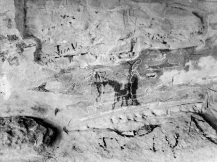
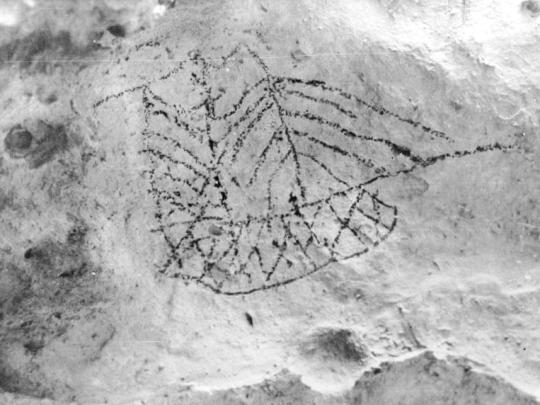
Traditional History The earliest traditions associated with human occupation of the South Island refer to Rākaihautū, the captain of the Uruao waka, which brought the Waitaha tribe to New Zealand. Rākaihautū beached his waka at Whakatū (Nelson) and divided the new arrivals into two groups, with his son Rakihouia taking one party south along the coastline and Rākaihautū taking another south by an inland route. On his inland journey, Rākaihautū used his kō (a digging implement) named Tuhiraki, to carve out the major lakes and subsequent waterways of Te Wai Pounamu . There are also important tribal histories and traditions relating to the Kāhui Tipua, Hawea and Rapuwai peoples that are closely connected with the North Otago region. As described in WAI 27 The Ngāi Tahu Report; Waitaha were both a people and a collection of peoples. The name refers to all those who were there prior to the Ngāti Mamoe and Ngāi Tahu migrations. Known by European scholars as Moa Hunters, the culture associated with the hunting of the moa had already gone with the passing of these flightless birds when Ngāi Tahu first crossed Cook Strait. Many traditional stories of the North Otago region are connected to the voyaging waka Arai-Te-Uru. Rongo-i-tua was a voyager from Hawaiki who introduced kūmara to the Kāhui Tipua people of the South Island. The Kāhui Tipua people assisted Rongo-i-tua in the construction of a canoe in order for him to return to Hawaiki and secure additional kūmara for cultivation in the south. On its return to the South Island the Arai-Te-Uru encountered a fierce storm, and as described in J. Herries Beattie's retelling of collected accounts, the crew was lost overboard at the mouth of the Waitaki River. The canoe was blown further down the east coast of the South Island, and after losing much of its cargo of kūmara at a beach near Moeraki (still visible in the landscape, known as the Moeraki boulders) the waka was wrecked at Matakaea (Shag Point) where it lies petrified in the landscape. This waka was also known for carrying a sacred fire from Hawaiki known as Te Ahi-Tapu-a-Uenuku. This fire had been buried along the Waikato River, but later dug up by the explorer Tamatea-Pōkai-Whenua prior to his circumnavigation of Aotearoa aboard the waka Takitimu. In the traditional stories recorded by J. C. Andersen, the limestone outcrops of North Otago are the legacy of Tamatea-Pōkai-Whenua. During his exploration he traversed the land, using this sacred flame for making fire as he went; as the fires cooled, mounds of pale white ash were left in their place, which became the limestone features that are so prominent in the landscape of this region. Andersen was told how Tamatea-Pōkai-Whenua journeyed along the Waitaki River, and near the river: …he cut out a cave for a house, which he ornamented with carvings and paintings. He cut out this cave in order to preserve the tuhutuhi (writing) which was brought from Irihia (beyond Hawaiki) by Uru-whenua and his three brothers. The origins of Ngāi Tahu also have connections to the east coast of the North Island. Tahu Pōtiki, the eponymous ancestor of Ngāi Tahu, descended from the Ngāti Porou tupuna, Paikea. The descendants of Tahu Pōtiki moved south to Wellington, then continued their migration to Te Wai Pounamu. Today, Ngāi Tahu manawhenua is recognised over a large part of the South Island. Māori in the Awamoko Valley Both iwi history and archaeological evidence show occupation by Māori in the Waitaki district over an extended period, with the inhabitants using a wide variety of natural resources. While the date of the earliest settlement in the Waitaki area remains unknown, there was extensive settlement throughout the Waitaki Valley when the moa existed, as shown in the widespread archaeological remains of moa bones with evidence of human modification. Archaeologists have suggested that Awamoko’s rock art sites, together with those in wider North Otago and South Canterbury, date from the first 500 years of human occupation in New Zealand. Awamoko was also a stopping place on the inland journey up the Waitaki River. Te Puna-a- Maru at the junction of Awamoko Stream and the Waitaki was the first major stopping place after starting at Waitaki River Mouth. Nineteenth Century Recording of Rock Art in North Otago North Otago rock art sites were the earliest to be recorded by Europeans in New Zealand. The earliest example of such was at Takiroa, about 10 kilometres from the Awamoko Valley. Walter Mantell sketched the drawings at the Takiroa site in 1852, publishing them in 1868. The Rev. J. W. Stack also discussed Māori rock art when he presented his “Sketch of the Traditional History of the South Island Maoris” to the Philosophical Institute of Canterbury at an 1877 meeting, and he noted that much of his information came from Peta Te Hone of Kaiapoi and other kaumātua of note from areas including Moeraki and Arowhenua. Stack’s sources attributed rock art to Ngāti Mamoe, who ‘…are said to have lived in caves, where traces of their occupation are shown in the rude drawings overlying those of a more ancient date’. James Herries Beattie published details in the Journal of Polynesian Society of his conversations with respected rangatira Taare Te Maiharoa, who spoke of the history of rock art. Te Maiharoa was regarded as one of the most knowledgeable experts on the early history of human occupation of the South Island, and shared information relating to rock art with Beattie: It was the people who came with Rākaihautū and their descendants who executed on sheltered cliff-faces the paintings, around the origin of which so much surmise has centred. My informant reckoned that the ancestors of these people had once had a system of writing very unlike English writing or printing, and that they lost much of the knowledge in coming from land to land, but still retained memories of it. These paintings represented their writing after they came to New Zealand, and preserved to them incidents of their history. Only the designs done in black are Waitaha work, and the method of making the paint has been traditionally handed down. There is a tree called monoao, which my informant had seen growing at Benmore (near Lake Hawea), and describes as like a macrocarpa, with branches that may grow many feet long and with leaves like matai (black pine). Probably no other kind of tree in New Zealand contains so much gum or resin (called ware in south, pia in north), and it will burn readily when green. The branches of this tree when burnt, give off a smoke, said my informant that would speedily turn white clothes black with soot. Screens were erected to direct the smokes against a tipaki (flax mat), and the soot was subsequently scraped into an ipu (carved wooden basin). Tarata trees would be chipped and the gum collected, and rautawhiri berries gathered. These berries or seeds were smashed and tightly squeezed into a whitau (flax bag) and hung by the fire, when the oil from them would drip into the ipu. The oil of the weka (woodhen) was also an ingredient, and these four items were mixed in certain proportions, “not too thick nor too thin,” and the result, said my informant, was “an ink that would stand for ever”. The claim that the paint so obtained was indelible is substantiated by the state of preservation of the work, as some of the black paintings are probably over 1,000 years old. The red paintings, continued my informant, were done many generations later than the black, and were the work of Kati-Mamoe, who simply copied the Waitaha figures. Beattie reported that another well-known rangatira Henare Te Maire, agreed with the kōrero of Te Maiharoa. Twentieth Century Recording of Rock Art Although some early New Zealand ethnologists may have seen the drawings as ‘idle scribblings of nomadic Maori’ , recognition of its importance by the Pākehā community was reconsidered from the 1940s when the Department of Internal Affairs hired Theo Schoon to document the rock art sites of South Canterbury and North Otago. Schoon began recording the drawings, seeking to make a realistic copy of what he saw. Later documentation began to ‘show his own interpretation of the original works’. He also began to retouch the works, using a crayon to ‘add clarity’. In the 1960s the artist Anthony (Tony) Fomison was involved in the recording of many sites and extensively sketched the art. He also traced over many works, and although ultimately damaging them in the process, Fomison accepted the drawings as works of art in their own right, and unlike Schoon did not try and alter them. Fomison’s analysis grouped the drawings into late or early periods according to ‘subject matter, superimposition or from excavation of cave floors.’ He distinguished three stylistic periods: Early Polynesian, Classic, and European Contact. Recording of Rock Art in the Awamoko Valley In 1967 the archaeologist Michael Trotter and his team made an intensive survey of the Awamoko valley. The Awamoko drawings were found to be in an area of high rock drawing concentration that spanned between Waianakarua and the Waitaki River. Rock art was found on cliff faces, the walls and roofs of rock overhangs and narrow crevices. Awamoko’s art is drawn on limestone rock. Limestone is a soft rock and often weathered into geological formations like caves or overhangs which provided protection for the artist and their artwork. The rock also provided a large, light-coloured canvas allowing for creativity and freedom of expression not normally available in other traditional canvases such as wood, bone, or stone. Birds are an important subject in the art and come second only to humans in frequency of occurrence across the North Otago region. They are often naturalistic and may have been based on observation. Given the artistic similarity among rock art sites in the North Otago area, archaeologists believe it seems likely rock artists and their hapū roamed widely throughout the area. Rock Art and New Zealand Art Māori rock art has been described as the earliest New Zealand artwork, and the rock art sites of South Canterbury and North Otago referred to as “New Zealand’s oldest art galleries”. The Ngāi Tahu artist Ross Hemera has commented on the importance of rock art in informing his work, stating, “These drawings, for me, are manifestations of our tipuna. So when I go back to the rock shelters, when I’m visiting, these are the occasions when I feel closest to the spirit of my ancestors”. New Zealanders have long been influenced by their experience with Māori rock art. Theo Schoon’s employment by the Department of Internal Affairs in 1947 to document rock art was formative in the development of his own art. New Zealand artist Gordon Walters accompanied Schoon on visits to rock art sites and Tony Fomison was involved in the recording of many sites and extensively sketched the art at various sites. Some nineteenth century ethnographers suggested that a practical reason also existed for the drawings. Dr Thomas Morland Hocken noted: Stephenson tells me regarding the drawings in the cave at Duntroon and that on the farm adjoining, that the old chief, now dead, told him that he could not decipher them but that his father told him when he was a boy (say 70 or 80 years ago) that they related to landmarks or boundaries… Rock art has been also described as ‘The first language of Te Waipounamu’. The drawings can be seen as an early form of written language, and Haast at first thought ‘they might be a kind of hieroglyphic writing’. Herries Beattie recorded: My informant reckoned that the ancestors of these people had once had a system of writing very unlike English writing or printing, and that they lost much of the knowledge in coming from land to land, but still retained memories of it. These paintings represented their writing after they came to New Zealand, and preserved to them incidents of their history. The rock art sites of the Awamoko valley were revisited in 1997 as part of the Ngāi Tahu Māori Rock Art Project (SIMRAP), then led by Brian Allingham. The work resulted in a significant increase in the number of examples of recorded rock art, and this number was expanded upon again in 2017 re-surveying work undertaken by the archaeologists Shar Briden and Matthew Hill for SIMRAP. The cultural and archaeological landscape of the Awamoko Valley has 84 recorded art sites, and the Awamoko Rock Art Site is an important representative example with diversity of depiction, scale, and pigment used. The importance of recognising and conserving the surviving rock art in the South Island is articulated by former Ngāi Tahu Rock Art Trust board member - Francese (Mandy) Home, who has described her deep feelings for the art, explaining that; Rock art is part of our whakapapa, it is the direct link with our early tūpuna who walked this land centuries ago acquainting themselves with a new life and new land. For a while we lost the connection through colonisation (other iwi as well as European) however we never lost the connection to this ancient art and our sense of belonging to this whenua.
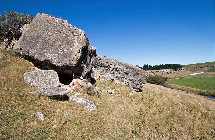
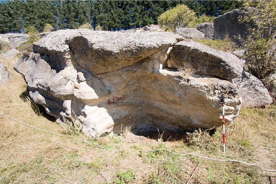
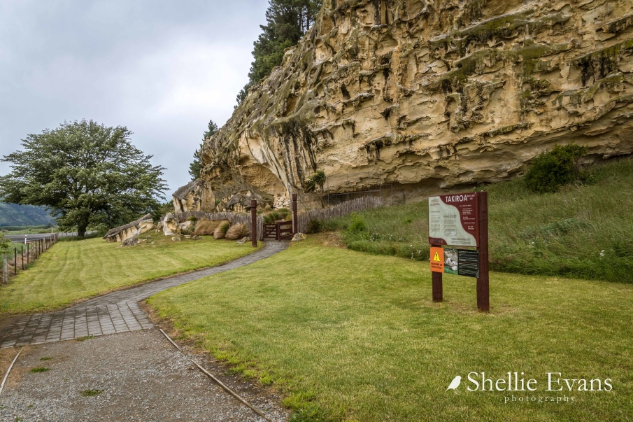
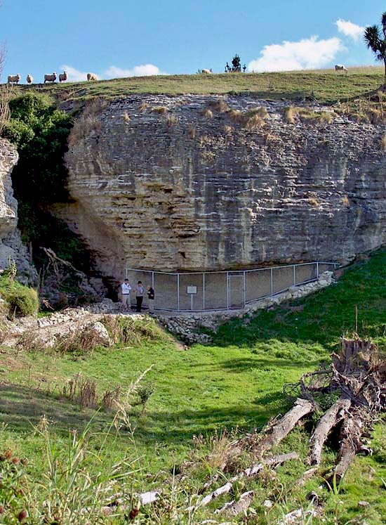
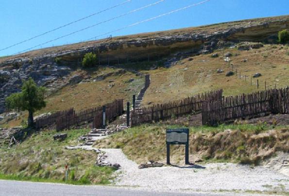
Current Description The Awamoko Rock Art Site is located within the limestone features of the Awamoko river in the Waitaki Valley. This area of North Otago, near the border of South Canterbury is rich with the limestone surfaces that are so often found to be used in Māori rock art. The Awamoko Rock Art Site is within the boundaries of a working farm, and is located near the farm’s border, amongst an outcrop of limestone boulders and caves that run approximately four kilometres along the northern boundary of the farm. Physical descriptions of each of the archaeological sites within the listing extent are as follows: I41/16 Drawing, Rock Shelter - SIMRAP 5.64 NZTM Grid Reference Easting: 1419565 Northing: 5023230 This shelter is formed by an overhang of a large boulder. On the underside of the boulder is a group of black drawings (including at least four profile humans and two bird forms). Six figures have been recorded. The art contains several naturalistic bird designs along with multiple stylistic human forms. The site record form from 1967 notes that the art had not been “retouched”. Some small fragments of moa bone and fresh-water mussel were noted by A. Fomison during his visits of the 1960’s. This site is described in the NZAA Site Record Form as “a small but important shelter”. I41/17 Midden, Drawing, Rock Shelter - SIMRAP 5.62 NZTM Grid Reference Easting: 1419578 Northing: 5023204 This small north-west facing shelter contains one rock art figure consisting of black curvilinear designs. Fresh-water mussel midden has been found on the floor of the rock shelter. I41/18 Cave/Rock Shelter - SIMRAP 5.82 NZTM Grid Reference Easting: 1419898 Northing: 5022845 Rock shelter containing linear fish forms and other line drawings. Five figures have been documented. Distinctive designs include a large black fish design, and several faded black tiki figures. I41/19 Drawing, Rock Shelter - SIMRAP 5.81 NZTM Grid Reference Easting: 1419923 Northing: 5022873 This shelter includes badly-flaked red painted drawing, overlain by black lines and a black form, and a black human figure. Seven figures have been documented. Distinctive designs include a large red, painted figure, and a red and black tiki figure. A fresh-water midden is also present. I41/20 Cave/Rock Shelter - SIMRAP 5.80 NZTM Grid Reference Easting: 1419927 Northing: 5022882 On an area on the downhill side of a boulder is a very low shelter containing fragments of six figures that have been documented. Distinctive designs include a tiki figure and a possible fish-like creature. Both black and red pigments have been used. I41/21 Cave/Rock Shelter - SIMRAP 5.79 NZTM Grid Reference Easting: 1419898 Northing: 5022908 This is a habitable shelter which includes faded black drawings – one human, on the north facing rock to the west of the shelter. Two black figures have been documented. One tiki figure and a design that possibly contains multiple birds. I41/28 Shelter Cave/Rock Shelter - SIMRAP 5.78 NZTM Grid Reference Easting: 1419934 Northing: 5023027 This shelter along the northern side of a rock outcrop contains both black and red drawings. Eight black fragmentary figures have been documented on the north face of a flat-topped boulder sitting at the foot of slope. The art includes several small bird figures and one mōkihi-like boat design. There is a midden nearby. Archaeologist Michael Trotter and his team excavated the midden in 1967. The team found fresh-water mussel shell, an oven or fireplace, and burnt stone. Orthoquartzite occurred in the oven. A piece of hematite was found. A few pieces of broken bird bone and a piece of charred moa bone were found in the ash of the oven. I41/29 Cave/Rock Shelter Cave like rock shelter where a trial hole found fresh-water mussel shell and moa bone. I41/30 Cave/Rock Shelter This is a small rock shelter in which a fresh-water mussel midden was found. I41/31- Cave/Rock Shelter This is a small shelter with a fresh-water mussel midden. I41/32 Cave/Rock Shelter This is a small shelter with a fresh-water mussel midden. I41/33 Cave/Rock Shelter In this small shelter a flake of obsidian was found. I41/34 Rock Shelter Small cave-like shelter with occupation evidence found including fresh-water mussel shells and charcoal. I41/35 Cave/Rock Shelter This site, close to a large rock, has an area of fresh water midden on the east side. I41/36 Cave/Rock Shelter - SIMRAP 5.60 NZTM Grid Reference Easting: 1419400 Northing: 5022760 This is a large shelter, with an area of midden. A 1967 test holes shows large quantities of fresh water shellfish, bird and dog bone, as well as lobster shell. Earlier finds included Dentalium (tusk) shells. Twelve rock art figures have been documented, containing both black and red fragments. It is worth noting that the original site record for this site did not identify any rock art, and it was only in 1997 when Brian Allingham conducted the first survey as part of the SIMRAP recording project that the rock art within this shelter was first identified. I41/37 Cave/Rock Shelter This is a small rock shelter containing fresh-water midden. I41/38 Cave/Rock Shelter Fragments of moa bone (not necessarily of Māori origin) were found in this shelter. In this shelter farmer and artist Burns Pollack found crayfish remains and a teka (dart head). I41/39 Cave/Rock Shelter This is a large shelter formed by the overhang of the cliff face. There is a midden on the floor and a talus midden on the slope outside the shelter. Oven stones and fresh-water mussel shells are visible on the floor and outside slope.
Public NZAA Number
I41/16
Completion Date
9th September 2019
Report Written By
Ellen Andersen and Susan Irvine
Information Sources
Andersen, 2000
J C Andersen, Maori Place Names, Cadsonbury Publications (reprint of 1942 ed.), Christchurch, 2000.
Anderson, 1998
Atholl Anderson, The Welcome of Strangers: An ethnohistory of southern Maori A.D. 1650-1850, Otago University Press in association with the Dunedin City Council, Dunedin, 1998
Beattie, 1994
James Herries Beattie, Traditional Lifeways of the Southern Maori, Otago University Press, Otago, 1994.
Duff, 1956
Roger Duff, The Moa-Hunter Period of Maori Culture. Government Printer, Wellington, 1956.
Evans, 1997 (2)
J. Evans, Nga Waka o Nehera, the first voyaging canoes, Reed Publishers, Auckland, 1997.
Hamilton, 1896
Augustus Hamilton, 'Notes on Murihiku'. Transactions and Proceedings of the New Zealand Institute, Volume 19, 1896.
Beattie, 1995
James Herries Beattie, Maori Place Names of the Peninsula, Cadsonbury Publications, (reprint of 1944 Ed.), Christchurch, 1995, 2001.
Keith, 2007
Hamish Keith, The Big Picture: A History of New Zealand Art from 1642, Random, Auckland, 2007.
Reed, 1963
A W Reed, Treasury of Maori Folklore, A.H. and A.W. Reed, Wellington, 1963.
Taylor, 1952
W A Taylor, Lore and History of the South Island Maori, Christchurch, 1952
Thompson, 1989
Paul Thompson, Maori Rock Art: An Ink that will Stand Forever, GP Books, New Zealand, 1989.
Trotter, 1981
M Trotter and B McCulloch, Prehistoric Rock Art of New Zealand, Longman Paul Ltd, Auckland, 1981.
Hamel, 2001
Jill Hamel, The Archaeology of Otago, Department of Conservation, Wellington, 2001
Fomison, (c.1970)
Fomison, A., Maori Rock Art in North Otago and South Canterbury, A Guide to the Interpretation of Its Styles and Subject Matter (c.1970). Ref: MS-0928, Hocken Library Collection, University of Otago, Dunedin.
Tau and Anderson, 2008
Tau, Te Maire, and Anderson, Atholl (Eds) ‘Ngai Tahu: A Migration History – The Carrington Text’, Bridget Williams Books Ltd, Wellington 2008.
Anderson, 1989
Atholl Anderson, Prodigious Birds: Moas and moa-hunting in prehistoric New Zealand, Cambridge University Press, Cambridge, 1989
Allingham, 1990
Allingham, B., Report on Māori Rock Art Recording Pilot Study in Coastal North Otago, funded by the N.Z.H.P.T., HNZPT Files, Otago/Southland Office, 1990.
Anderson, 1988
Atholl Anderson, ‘The art of concealment: Some thoughts on South Island Maori rock drawings’, pp.1-19 in National Museum of New Zealand Te Whare Taonga o Aotearoa and Manawatu Art Gallery, Ka tuhituhi o nehera, The drawings of ancient times. Wellington: National Museum of New Zealand Te Whare Taonga o Aotearoa and Manawatu Art Gallery, 1988.
Bain, 1982
Pam J. Bain, Maori rock drawings. A stylistic analysis of drawings in North Otago and South Canterbury. Unpublished M.A. thesis, Anthropology Department, University of Otago, 1982.
Bain, 1985
Pam Bain, Geographic and temporal variation in Maori rock drawings in two regions of southern New Zealand, New Zealand Journal of Archaeology, 7, pp. 39-59, 1985.
Beattie, 1918
James Herries Beattie, Traditions and legends: Collected from the natives of Murihiku (Southland, New Zealand), Part VIII, Journal of the Polynesian Society, 27(3), 1918, pp.137-161.
Beattie, 1881/1972
James Herries Beattie, Notes relating to rock paintings (1896-1922) MS-0475/007, 1881/1972.
Beattie, 1881/1972
James Herries Beattie, Notes relating to rock paintings (1896-1922) MS-0475/007, 1881/1972.
Low, 2015
Low, N. The first language of Te Waipounamu, Te Karaka, April 2015, https://ngaitahu.iwi.nz/our_stories/the-first-languageof-te-waipounamu/, accessed 19 June 2019
McCulloch, 1985
McCulloch, B., Māori rock drawings: A matter of interpretation, in Māori rock drawing – The Theo Schoon interpretations exhibition catalogue, Robert McDougall Art Gallery, Christchurch City Council, 1985.
Roberts, 1985
Roberts, N., Maori rock drawing and Theo Schoon in Māori rock drawing – The Theo Schoon interpretations exhibition catalogue, Robert McDougall Art Gallery, Christchurch City Council, 1985.
Schoon, 1947
Theo Schoon, New Zealand’s oldest art galleries, New Zealand Listener, September 12, pp.6-7, 1947.
Stack, 1877
J. W. Stack, Sketch of the traditional history of the South Island Maoris, Transactions and Proceedings of the Royal Society of New Zealand. Volume 10, pp.57-92, 1877.
Symon
Amanda Symon, Stories in stone, Timaru Courier, 9 February, 2012.
von Haast, 1877
Julius Von Haast, Address read before the Philosophical Institute of Canterbury, 5th April, 1877, Transactions and Proceedings of the Royal Society of New Zealand, vol. 10, pp. 31-54 http://rsnz.natlib.govt.nz/volume/rsnz_10/rsnz_10_00_000480.html p.47, accessed 27 June 2019
Waitangi Tribunal, 1991
Waitangi Tribunal, The Ngāi Tahu report, Wai 27, WTR 3, Brooker and Friend Ltd, Wellington, 1991.
Report Written By
Please note that entry on the New Zealand Heritage List/Rarangi Korero identifies only the heritage values of the property concerned, and should not be construed as advice on the state of the property, or as a comment of its soundness or safety, including in regard to earthquake risk, safety in the event of fire, or insanitary conditions. Archaeological sites are protected by the Heritage New Zealand Pouhere Taonga Act 2014, regardless of whether they are entered on the New Zealand Heritage List/Rārangi Kōrero or not. Archaeological sites include ‘places associated with pre-1900 human activity, where there may be evidence relating to the history of New Zealand’. This List entry report should not be read as a statement on whether or not the archaeological provisions of the Act apply to the property (s) concerned. Please contact your local Heritage New Zealand office for archaeological advice. A fully referenced New Zealand Heritage List report is available on request from the Dunedin Office of Heritage New Zealand Pouhere Taonga.
Current Usages
Uses: Maori
Specific Usage: Site of mythological event/ traditional or cultural importance
Former Usages
General Usage:: Cultural Landscape
Specific Usage: Ancestral landscape
General Usage:: Maori
Specific Usage: Art site
General Usage:: Maori
Specific Usage: Cave/ rock shelter
General Usage:: Maori
Specific Usage: Occupational site - temporary
General Usage:: Maori
Specific Usage: Rock art
Themes
Archaeological Site (HPA 1980)
Of Significance to Maori
Related listings


Stay up to date with Heritage this month
