DonateMembershipVisit Heritage
  • Tūrangawaewae
    Places
  • Tira Māori
    Māori Heritage
  • Poutairangahia
    Archaeology
  • Rauemi
    Resources
  • Mō Tātou
    About Us
  • New Zealand Heritage List
  • Nominate and submit
  • Explore the List
  • National Historic Landmarks
  • Plaques
  • Rainbow List Project
  • Lost heritage
  • Visit Heritage
  • Our properties
  • Turnbull House Project
  • Collections
  • Shop
  • Tohu Whenua
  • Tira Māori
  • Conserving Māori heritage
  • Marae built heritage
  • Māori heritage on the List
  • Hinemihi—Te Hokinga Mai
  • What is archaeology?
  • Is there a site on my property?
  • What are my legal requirements?
  • Affecting an archaeological site
  • Declaring an archaeological site
  • Archaeology FAQs
  • Archaeology Digital Library
  • Archaeology guidelines and templates
  • Resources
  • Funding
  • Publications
  • Sustainable management guides
  • Disaster recovery
  • Podcasts & digital resources
  • Education Hub
  • Conservation plans
  • About
  • Board
  • Māori Heritage Council
  • Senior Staff
  • Offices
  • Contact us
  • Careers
  • Covenants
  • Fast-track
  • Corporate documents
  • Currently consulting on
  • Our submissions
  • News
  • Covid-19 response
Quick links
Rārangi Kōrero | The List
Explore the List
National Historic Landmarks
Ngā Manawhenua o Aotearoa me ōna Kōrero Tūturu
Quick links
Tapuwae
A Vision for Places of Māori Heritage
Funding for Māori Heritage
Resources
Quick links
Archaeological Authority Portal
Applying for an archaeological authority
Archaeology FAQs
Browse the most frequently asked questions about archaeological authorities and the archaeological process.
Quick links
Quick links
News
News Keep up to date with Heritage New Zealand Pouhere Taonga
Membership
Membership Find out more and sign up today
  • Places
  • Nominate and submit
  • National Historic Landmarks
  • Places
  • Nominate and submit
  • National Historic Landmarks
  • Tira Māori
  • Conserving Māori heritage
  • Marae built heritage
  • Tira Māori
  • Conserving Māori heritage
  • Marae built heritage
  • Archaeological authorities
  • Archaeology Digital Library
  • Archaeological authorities
  • Archaeology Digital Library
  • All resources
  • Publications
  • Funding
  • All resources
  • Publications
  • Funding
  • FAQs
  • FAQs
Follow us on:
Places
  • Places
  • Nominate and submit
  • National Historic Landmarks
Tira Māori
  • Tira Māori
  • Conserving Māori heritage
  • Marae built heritage
Archaeology
  • Archaeological authorities
  • Archaeology Digital Library
Resources
  • All resources
  • Publications
  • Funding
FAQs
  • FAQs
Follow us on
HomePrivacyTerms and conditionsAbout this site
© Heritage New Zealand Pouhere Taonga 2026.
 
Ratau

Mangaheia Station, Tauwhareparae Road, TOLAGA BAY

Private

Historic Place Category 2

List No. 6546

Quick links:
List GalleryLocationDetails
Ratau is large pa that forms part of the dense archaeological landscape of the Tolaga Bay (Uawa) area. It is located on the high point of a major east-west running ridgeline on Mangaheia Station, west of Tolaga Bay.

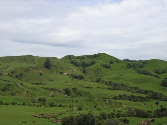
Ratau is one of the numerous pa that have been recorded in the Tolaga Bay area, mostly located on the prominent hills and ridgelines which afforded excellent natural defences and provided commanding views of the surrounding landscape. These pa and the many other archaeological sites recorded in the Uawa region such as pit and terrace complexes, midden, gardens and urupa reflect the intensive occupation of this landscape by Maori from the time of initial Polynesian settlement approximately 700 years ago. Access to abundant food resources from the sea, rivers, inland forests and horticultural production (kumara) meant that a large population could be sustained. It has been estimated that the early Maori population of Tolaga Bay totalled approximately 1200; and the main iwi was Te Aitanga a Hauiti.

Ratau is believed to have been occupied by the iwi known as 'Tarewa', who were subsequently overthrown by a neighbouring Mangaheia Valley iwi. The descendants of this Mangaheia Valley iwi were later known as 'Hingaroa'. The name Ratau means 'last hill to catch the sun at the end of the day'. The approximate date/period of Tarewa's occupation of Ratau is unclear.

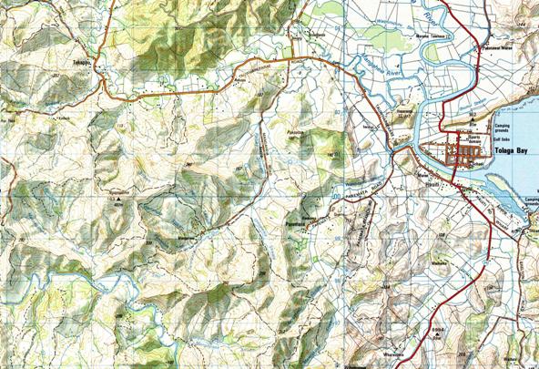
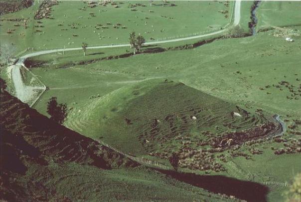
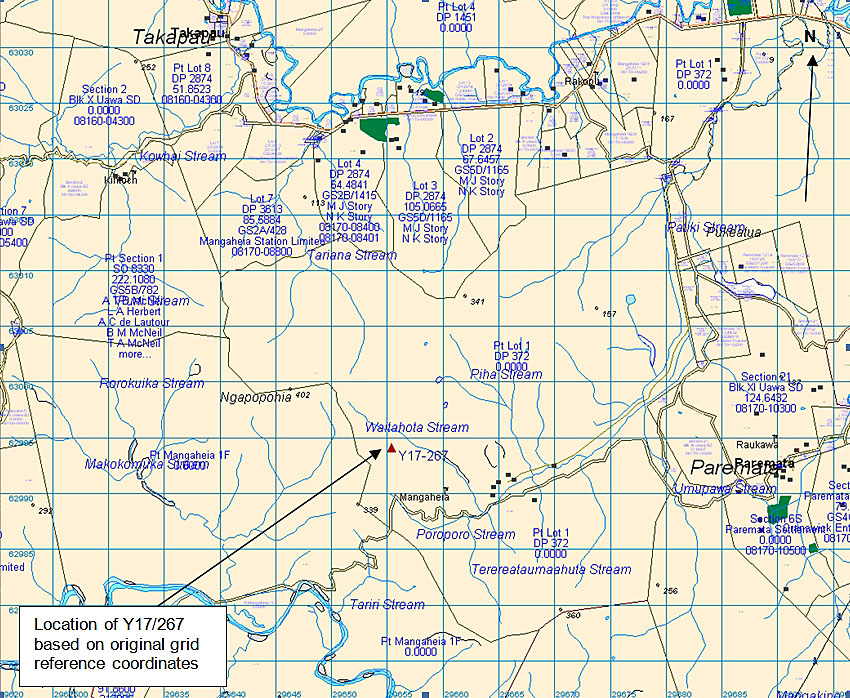
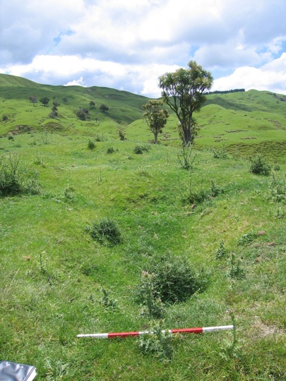
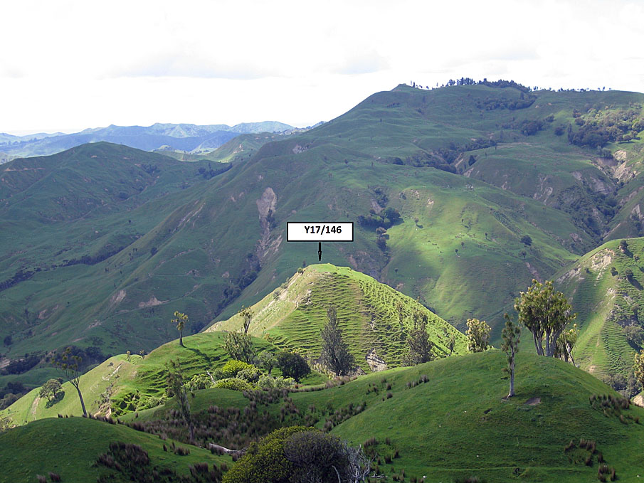
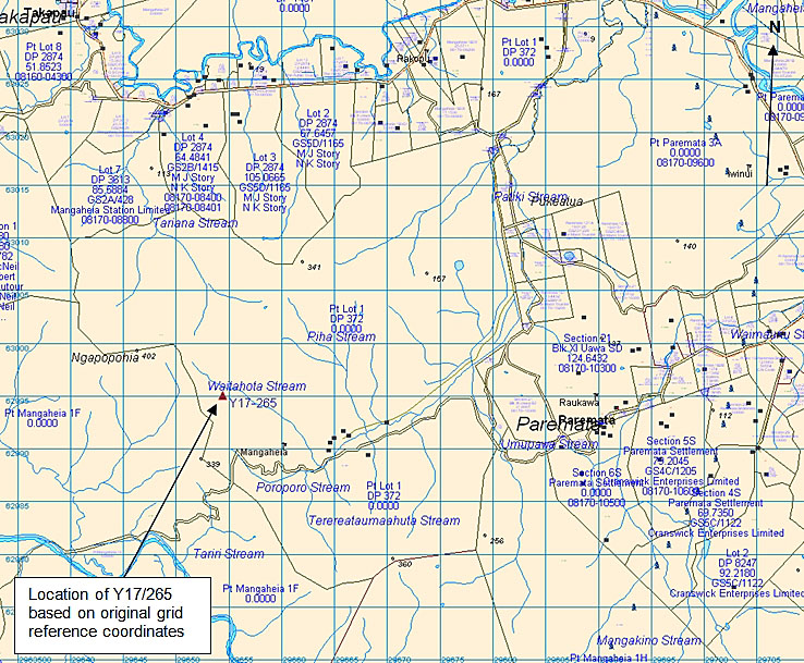
Ratau is located in pasture on the peak of a major east-west running ridgeline approximately 1.3 kilometres west of Mangaheia Road, where there is a bridge over the Patiki Stream. The pa mostly occupies the very narrow, steep-sided ridge crest, extending for a length of approximately 200-220 metres, and it is generally no more than 8 metres in width. It possesses both natural and artificial defences. Pit site Y17/167 is located immediately to the northwest of the pa (and is considered to be associated with it) and there are a number of other recorded archaeological sites in the surrounding area.

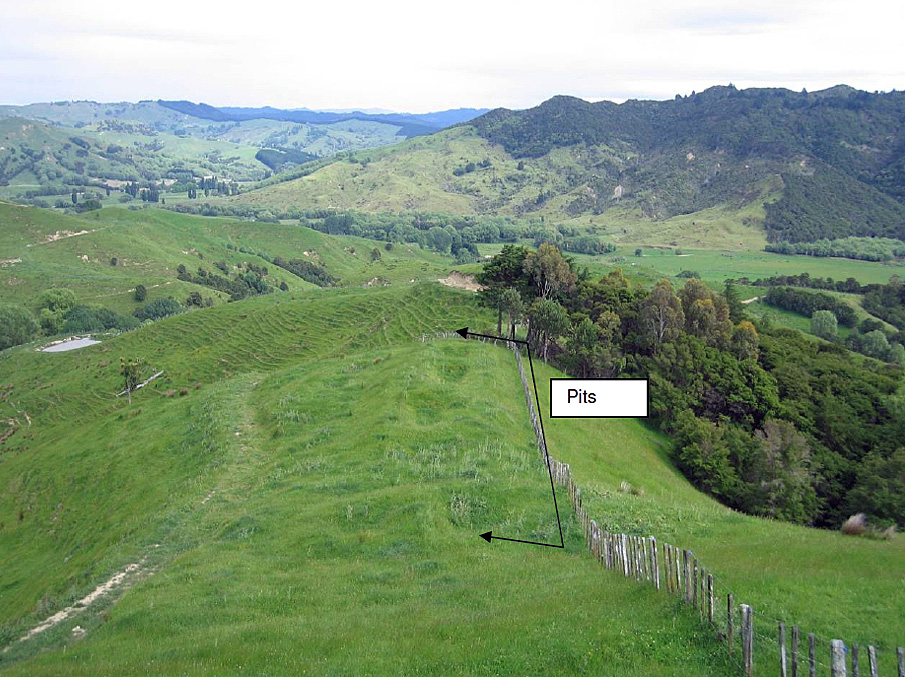
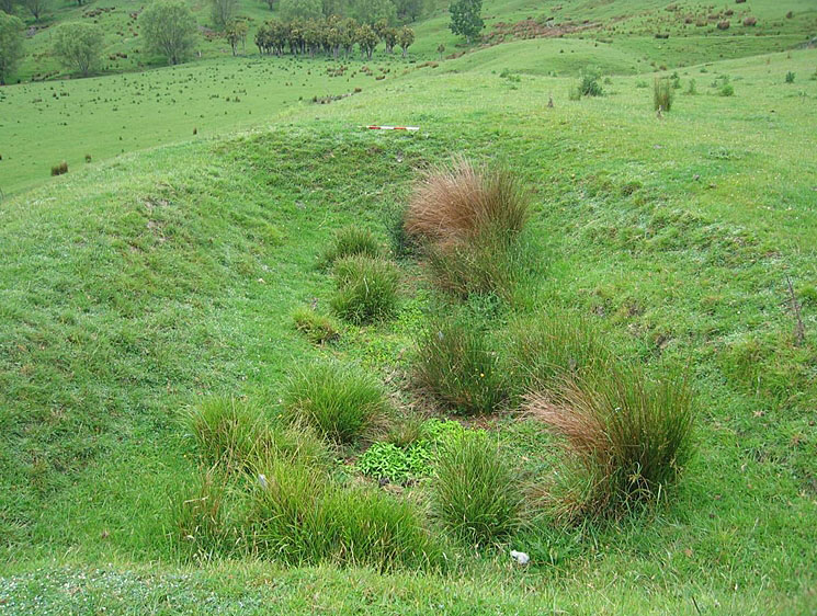
This pa was first recorded by archaeologist Kevin Jones during his archaeological survey work in the Whangara, Tolaga Bay and Uawa Catchment areas in 1982-1983. This survey work was undertaken to gain information about the nature of prehistoric settlement in this locality, and also to evaluate specific sites for registration under the Historic Places Act 1980. Jones described the site as 'a ridge pa some 200m long with strong natural defences' and later estimated that it could have sustained a population of approximately 167 individuals. An artificial defence in the form of a double ditch and bank cut across the principal ridge of the pa, dividing it into 'east and west'. A number of pits were also recorded within the pa, particularly along the ridge running down to the northwest from the principal ridgeline. With regards to the condition of the pa, stock damage was noted as an issue. The narrowness of the principal ridgeline meant that the site was particularly vulnerable to damage from stock moving along the ridge crest.

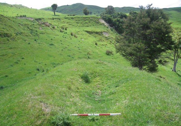
Ratau was revisited by archaeologist Bridget Mosley in 2000 as part of the New Zealand Archaeological Association Site Recording Scheme Upgrade Project. Mosley noted that the pa was significantly eroded at its eastern and western ends, and in average condition overall. The erosion meant that features such as the double ditch and bank were difficult to re-identify.

A slip was observed at the south-western end of Ratau during a New Zealand Historic Places Trust site visit in November 2007, but no other major changes were noted.

Ratau is one of the numerous pa recorded in the Tolaga Bay area, particularly in the Mangaheia Valley, and it is part of a much wider archaeological and cultural landscape that is of considerable significance to Te Aitanga a Hauiti. This landscape reflects the intensive Maori occupation and settlement of the Tolaga Bay area since the 14th - 15th centuries AD.
Ratau. Looking northwest across to Ratau | Joanna Wylie | 16/11/2007 | Heritage New Zealand
Ratau | Heritage New Zealand
Ratau. Looking northwest across to Ratau | Joanna Wylie | 16/11/2007 | Heritage New Zealand
Ratau | Heritage New Zealand

List Entry Information

Overview

Status
Listed

List Entry Status
Historic Place Category 2

Access
Private/No Public Access

List Number
6546

Date Entered
25th September 1986

Date of Effect
25th September 1986

City/District Council
Gisborne District

Region
Gisborne Region

Extent of List Entry

The registration includes part of the land described as Pt Lot 1 DP 372, Block XI Uawa Survey District, Gisborne Land District and the pa known as Ratau.

Legal description

Pt Lot 1 DP 372, Blk XI Uawa SD (RT GS1C/129), Gisborne Land District

Detailed List Entry
Reference

Public NZAA Number

Y17/168

Completion Date

8th March 2008

Report Written By

Joanna Wylie

Information Sources

Department of Conservation

Department of Conservation

New Zealand Journal of Archaeology

New Zealand Journal of Archaeology

New Zealand Archaeological Association (NZAA)

New Zealand Archaeological Association

Report Written By

This place was identified as significant under previous legislation with different information requirements. It remains significant under the current legislation. There is opportunity under our legislation and policies to add to this information. Further information about this place may be available from the Lower Northern Office of Heritage New Zealand Pouhere Taonga. Iwi/ Hapu/ Whanau: Te Aitanga a Hauiti A fully referenced upgrade report is available from the NZHPT Lower Northern Area Office Please note that entry on the New Zealand Heritage List/Rarangi Korero identifies only the heritage values of the property concerned, and should not be construed as advice on the state of the property, or as a comment of its soundness or safety, including in regard to earthquake risk, safety in the event of fire, or insanitary conditions.

Further Information

Current Usages

Uses: Agriculture

Specific Usage: Farm

Former Usages

General Usage:: Maori

Specific Usage: Pā

Themes

Of Significance to Maori

Web Links

Overview

Status

Listed

List Entry Status

Historic Place Category 2

Access

Private/No Public Access

List Number

6546

Date Entered

25th September 1986

Date of Effect

25th September 1986

City/District Council

Gisborne District

Region

Gisborne Region

Extent of List Entry

The registration includes part of the land described as Pt Lot 1 DP 372, Block XI Uawa Survey District, Gisborne Land District and the pa known as Ratau.

Legal description

Pt Lot 1 DP 372, Blk XI Uawa SD (RT GS1C/129), Gisborne Land District

Reference

Historical and Associated Iwi / Hapū / Whānau

Public NZAA Number

Y17/168

Completion Date

8th March 2008

Report Written By

Joanna Wylie

Information Sources

Department of Conservation

Department of Conservation

New Zealand Journal of Archaeology

New Zealand Journal of Archaeology

New Zealand Archaeological Association (NZAA)

New Zealand Archaeological Association

Other Information

This place was identified as significant under previous legislation with different information requirements. It remains significant under the current legislation. There is opportunity under our legislation and policies to add to this information. Further information about this place may be available from the Lower Northern Office of Heritage New Zealand Pouhere Taonga. Iwi/ Hapu/ Whanau: Te Aitanga a Hauiti A fully referenced upgrade report is available from the NZHPT Lower Northern Area Office Please note that entry on the New Zealand Heritage List/Rarangi Korero identifies only the heritage values of the property concerned, and should not be construed as advice on the state of the property, or as a comment of its soundness or safety, including in regard to earthquake risk, safety in the event of fire, or insanitary conditions.

Further Information

Current Usages

Uses: Agriculture

Specific Usage: Farm

Former Usages

General Usage: Maori

Specific Usage: Pā

Themes

Of Significance to Maori

Current Usages

Uses: Agriculture

Specific Usage: Farm

Former Usages

General Usage: Maori

Specific Usage: Pā

Themes

Of Significance to Maori

Location

Loading
Related listings
Pa. Looking north
Pā
Pa. Close up of large pit looking approximately northeast
Pā
Gunfighter Pa. Looking east towards ditch and bank defences
Gunfighter Pā
Pits. Map produced from Quickmap, Version 6.3.112
Pits
Pits/ Terrace
Pits/ Terrace
Pits/ Terrace. 'Pit B' looking NNW
Pits/ Terrace
Ngapopohia. Looking west at trig and surrounding terracing
Ngapopohia
Pits. Looking west over pits -Y17/167
Pits
Pits. K L Jones NZAA Site Record No. Y17/182 August 1982. Heritage New Zealand Archaeological Slide Collection - Ref. 3092
Pits
Pits/ Terraces. Close-up of pit looking south
Pits/ Terraces
Pits. Map produced from Quickmap, Version 6.3.112
Pits
Pits
Pits
Pa. Looking east towards Y17/146
Pā
Ngapopohia. Looking west at trig and surrounding terracing
Ngapopohia
Pa. Looking north
Pā
Pits. Looking west over pits -Y17/167
Pits
Pa. Close up of large pit looking approximately northeast
Pā
Pits. K L Jones NZAA Site Record No. Y17/182 August 1982. Heritage New Zealand Archaeological Slide Collection - Ref. 3092
Pits
Gunfighter Pa. Looking east towards ditch and bank defences
Gunfighter Pā
Pits/ Terraces. Close-up of pit looking south
Pits/ Terraces
Pits. Map produced from Quickmap, Version 6.3.112
Pits
Pits. Map produced from Quickmap, Version 6.3.112
Pits
Pits/ Terrace
Pits/ Terrace
Pits
Pits
Pits/ Terrace. 'Pit B' looking NNW
Pits/ Terrace
Pa. Looking east towards Y17/146
Pā
Stay up to date with Heritage this month