

Numerous pa and many other archaeological sites recorded in the Uawa region such as pit and terrace complexes, midden, gardens and urupa reflect the intensive occupation of this landscape by Maori from the time of initial Polynesian settlement approximately 700 years ago. Access to abundant food resources from the sea, rivers, inland forests and horticultural production (kumara) meant that a large population could be sustained. It has been estimated that the early Maori population of Tolaga Bay totalled approximately 1200; and the main iwi was Te Aitanga a Hauiti.
Most of the recorded archaeological sites in the Tolaga Bay area date to the pre-European contact period, but this pa is unique in that it dates to the 19th century, following the introduction of the musket into New Zealand. It is a gunfighter pa - a specific style of pa that adapted from traditional Maori pa constructing techniques to suit fighting with guns and artillery. Typical features of gunfighter pa include rifle pits and trenches. Y17/200 is the only gunfighter pa recorded in the immediate Tolaga Bay area; the nearest recorded examples are located further inland at Puha (New Zealand Archaeological Association Site Record Number Y17/472) and Whatatutu (New Zealand Archaeological Association Site Record Number Y17/315).
As noted above, this pa is thought be Maea a te Ahu, occupied in approximately 1829, but it is difficult to verify this on the basis of the information available. Maea a te Ahu was the site of a battle fought by Te Whanau a Ruataupare against Te Aitanga a Hauti and Ngati Ira, to avenge the death of Ngati Porou chief Te Rerehorua. Te Rerehorua was killed at Tuatini, the Ngati Porou pa at Tokomaru Bay. As described by Wi Mahuika:
After Te Rerehorua's death Te Whanau-a-Rua rose up to avenge his death and fought a battle with Te Aitanga-a-Hauiti and Ngati Ira. Before the battle was fought, Ngati Ira withdrew to a place called Maea-a-te-Ahu and were joined by Te Aitanga a Hauiti. Te Whanau-a-Ruataupere fought against them here and defeated them. Ngati Ira fled to Turanga, to my father, Te Aitanga-a-Hauiti fled to the sea coast. The land was left without inhabitants.
Wi Kingi Hori's evidence differs slightly, as he states that some of the people remained on the land after Maea a te Ahu was overthrown. Tui tuakana makea Marino of Te Aitanga a Hauiti recently also advised that Te Aitanga a Hauiti did not all flee the land. He notes that sections of Te Aitanga a Hauiti returned to their lands on the southern boundary with their Turanga (Gisborne) relatives and that Te Whanau-a-Ruataupere went to live at Wharekahika. When Te Whanau-a-Ruataupere later wished to return to the land they were advised to make peace with Te Kani-a-Takirau. Te Kani-a-Takirau married Te Amotawa, Te Rerehorua's sister, and this union which went some way to uniting Te Whanau-a-Ruataupere and Te Aitanga a Hauiti. Te Kani-a-Takirau then sent for Te Whanau-a-Ruataupare to come and clean flax, which they did, staying in Tolaga Bay (Uawa) for four years.
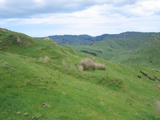
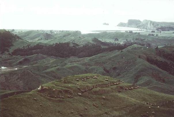
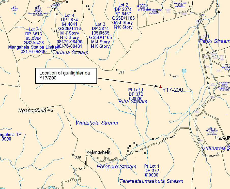
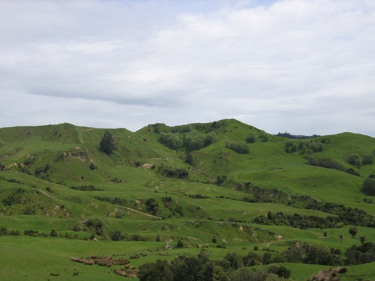
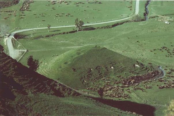
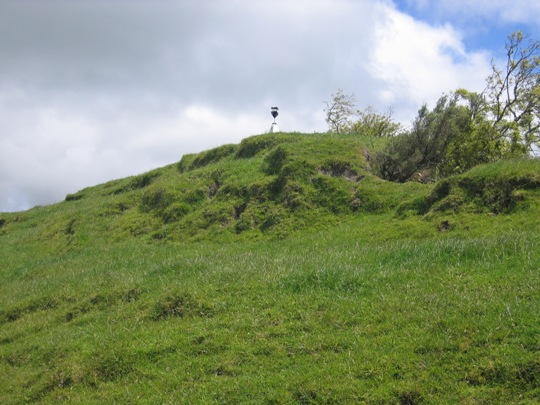
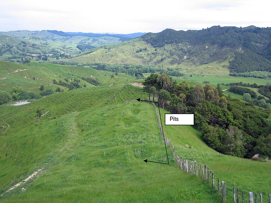
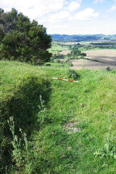
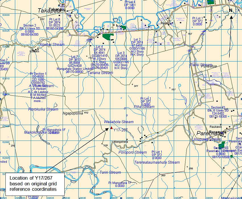
This gunfighter pa is located in pasture on a northwest-southeast running ridgeline approximately 1.6 kilometres southwest of the bridge on Mangaheia Road, where the Patiki Stream passes through. It has both natural and artificial defences, and provides strategic views to the surrounding area, such as eastward to Tolaga Bay. A number of other recorded archaeological sites are located in the vicinity, such as pit/ terrace site Y17/199, on the ridgeline running north from the gunfighter pa.
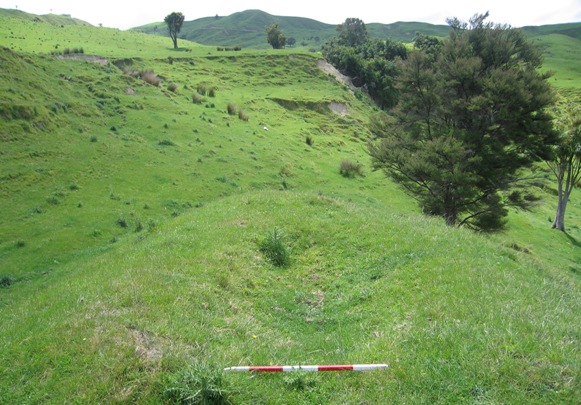
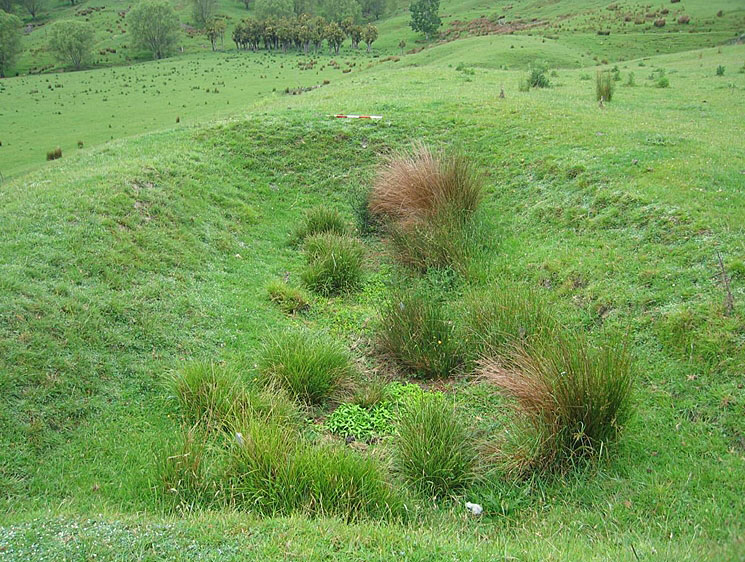
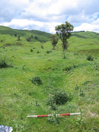
The gunfighter pa was first recorded by archaeologist Kevin Jones during his archaeological survey work in the Whangara, Tolaga Bay and Uawa Catchment areas in 1982-1983. This survey work was undertaken to gain information about the nature of prehistoric settlement in this locality, and also to evaluate specific sites for registration under the Historic Places Act 1980. Jones noted that the pa was naturally defended to the north and east by steep slopes, with artificial defences to the south and west. A double rifle trench (with transverse trenches to the inner part of the pa) ran across the southern slope, and a double ditch and bank protected the pa from the west. Jones also recorded a row of pits along the ridge crest, which may have predated the gunfighter pa. The pa measured approximately 75 metres x 25 metres, and Jones later estimated that it could have sustained a population of 30 individuals.
The gunfighter pa was revisited by archaeologist Vanessa Tanner in 2000 as part of the New Zealand Archaeological Association Site Recording Scheme Upgrade Project. Tanner found that the pa was as originally recorded but subject to ongoing stock damage, and recommended that cattle be kept off the site. No major changes were observed during a NZHPT site visit in November 2007, but stock damage continues to be a threat to the site. Stock damage was particularly noticeable along the row of pits on the ridge crest.
Gunfighter pa Y17/200 has archaeological significance as the only gunfighter pa recorded within the immediate Tolaga Bay area, and it is a place of cultural traditional and spiritual significance to Te Aitanga a Hauiti. It is thought to be Maea a te Ahu, the site of a battle between Te Whanau-a-Ruataupare and Te Aitanga a Hauti and Ngati Ira. The pa also forms part of a much wider archaeological and cultural landscape that is of considerable significance to Te Aitanga a Hauiti, reflecting the intensive Maori occupation and settlement of the Tolaga Bay area since the 14th - 15th centuries AD.
List Entry Information
Status
Listed
List Entry Status
Historic Place Category 2
Access
Private/No Public Access
List Number
6549
Date Entered
25th September 1986
Date of Effect
25th September 1986
City/District Council
Gisborne District
Region
Gisborne Region
Extent of List Entry
Registration includes part of the land described as Pt Lot 1 DP 372, Block XI Uawa Survey District, Gisborne Land District and the gunfighter pa known as Y17/200 (New Zealand Archaeological Association Site Record Form) thereon.
Legal description
Pt Lot 1 DP 372, Blk XI Uawa SD (RT GS1C/129), Gisborne Land District
Historical and Associated Iwi / Hapū / Whānau
Public NZAA Number
Y17/200
Completion Date
8th March 2008
Report Written By
Joanna Wylie
Information Sources
Archives New Zealand (Wgtn)
Archives New Zealand (Wellington)
Department of Conservation
Department of Conservation
Laurie, 1991
John Laurie, Tolaga Bay: A History of the Uawa District, H.B. Williams Memorial Library, Gisborne, 1991.
New Zealand Journal of Archaeology
New Zealand Journal of Archaeology
New Zealand Archaeological Association (NZAA)
New Zealand Archaeological Association
Other Information
This place was identified as significant under previous legislation with different information requirements. It remains significant under the current legislation. There is opportunity under our legislation and policies to add to this information. Further information about this place may be available from the Lower Northern Office of Heritage New Zealand Pouhere Taonga. Iwi/ Hapu/ Whanau: Te Aitanga a Hauiti A fully referenced upgrade report is available from the NZHPT Lower Northern Area Office Please note that entry on the New Zealand Heritage List/Rarangi Korero identifies only the heritage values of the property concerned, and should not be construed as advice on the state of the property, or as a comment of its soundness or safety, including in regard to earthquake risk, safety in the event of fire, or insanitary conditions.
Current Usages
Uses: Agriculture
Specific Usage: Farm
Former Usages
General Usage: Maori
Specific Usage: Pā
Themes
Of Significance to Maori
Current Usages
Uses: Agriculture
Specific Usage: Farm
Former Usages
General Usage: Maori
Specific Usage: Pā
Themes
Of Significance to Maori
Location
Related listings
Sign up to hear more
Get the latest heritage news, features and events delivered
straight to your inbox.
