DonateMembershipVisit Heritage
  • Tūrangawaewae
    Places
  • Tira Māori
    Māori Heritage
  • Poutairangahia
    Archaeology
  • Rauemi
    Resources
  • Mō Tātou
    About Us
  • New Zealand Heritage List
  • Nominate and submit
  • Explore the List
  • National Historic Landmarks
  • Plaques
  • Rainbow List Project
  • Lost heritage
  • Visit Heritage
  • Our properties
  • Turnbull House Project
  • Collections
  • Shop
  • Tohu Whenua
  • Tira Māori
  • Conserving Māori heritage
  • Marae built heritage
  • Māori heritage on the List
  • Hinemihi—Te Hokinga Mai
  • What is archaeology?
  • Is there a site on my property?
  • What are my legal requirements?
  • Affecting an archaeological site
  • Declaring an archaeological site
  • Archaeology FAQs
  • Archaeology Digital Library
  • Archaeology guidelines and templates
  • Resources
  • Funding
  • Publications
  • Sustainable management guides
  • Disaster recovery
  • Podcasts & digital resources
  • Education Hub
  • Conservation plans
  • About
  • Board
  • Māori Heritage Council
  • Senior Staff
  • Offices
  • Contact us
  • Careers
  • Covenants
  • Fast-track
  • Corporate documents
  • Currently consulting on
  • Our submissions
  • News
  • Covid-19 response
Quick links
Rārangi Kōrero | The List
Explore the List
National Historic Landmarks
Ngā Manawhenua o Aotearoa me ōna Kōrero Tūturu
Quick links
Tapuwae
A Vision for Places of Māori Heritage
Funding for Māori Heritage
Resources
Quick links
Archaeological Authority Portal
Applying for an archaeological authority
Archaeology FAQs
Browse the most frequently asked questions about archaeological authorities and the archaeological process.
Quick links
Quick links
News
News Keep up to date with Heritage New Zealand Pouhere Taonga
Membership
Membership Find out more and sign up today
  • Places
  • Nominate and submit
  • National Historic Landmarks
  • Places
  • Nominate and submit
  • National Historic Landmarks
  • Tira Māori
  • Conserving Māori heritage
  • Marae built heritage
  • Tira Māori
  • Conserving Māori heritage
  • Marae built heritage
  • Archaeological authorities
  • Archaeology Digital Library
  • Archaeological authorities
  • Archaeology Digital Library
  • All resources
  • Publications
  • Funding
  • All resources
  • Publications
  • Funding
  • FAQs
  • FAQs
Follow us on:
Places
  • Places
  • Nominate and submit
  • National Historic Landmarks
Tira Māori
  • Tira Māori
  • Conserving Māori heritage
  • Marae built heritage
Archaeology
  • Archaeological authorities
  • Archaeology Digital Library
Resources
  • All resources
  • Publications
  • Funding
FAQs
  • FAQs
Follow us on
HomePrivacyTerms and conditionsAbout this site
© Heritage New Zealand Pouhere Taonga 2026.
 
Haparangi

Iwinui Station, Tauwhareparae Road, TOLAGA BAY

Private

Historic Place Category 2

List No. 6627

Quick links:
List GalleryLocationDetails
Haparangi is a small terraced pa that forms part of the dense archaeological landscape of the Tolaga Bay (Uawa) area. It is located on Iwinui Station, Tolaga Bay, on Haparangi hill at the confluence of the Waimanu Stream and Uawa River.

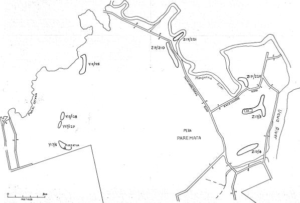
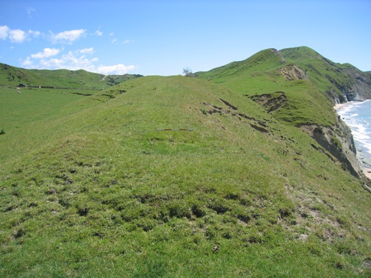
Haparangi is one of the numerous pa that have been recorded in the Tolaga Bay area, particularly in the Mangaheia Valley to the northwest of the township. They are mostly located on the prominent hills and ridgelines, which afforded excellent natural defences and provided commanding views of the surrounding landscape. Together with the many other archaeological sites recorded such as pit and terrace complexes, midden, gardens and urupa, they reflect the intensive occupation of this landscape by Maori from the time of initial Polynesian settlement approximately 700 years ago. A large population was able to be sustained by access to abundant food resources from the sea, rivers, inland forests and fertile soils, which were well-suited to kumara gardening. It has been estimated that the early Maori population of Tolaga Bay totalled approximately 1200; and the main iwi was Te Aitanga a Hauiti.

Haparangi was possibly occupied contemporaneously with the pa on Taharangi hill (Taharangi pa Z17/3 and pa site Z17/5), and the nearby village (Z17/24) on the western bank of the Uawa River. These sites were occupied in 1835 when trader Joseph Polack visited Tolaga Bay. They have also been registered as part of the Taharangi and Haparangi wahi tapu area (Record Number 7461), nominated by Te Whanau a Rangiuia, and endorsed by Te Aitanga a Hauiti.

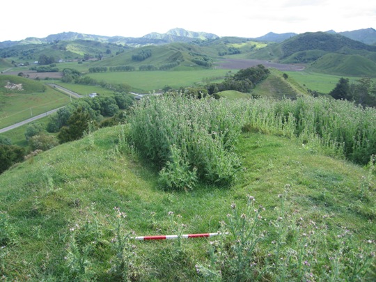
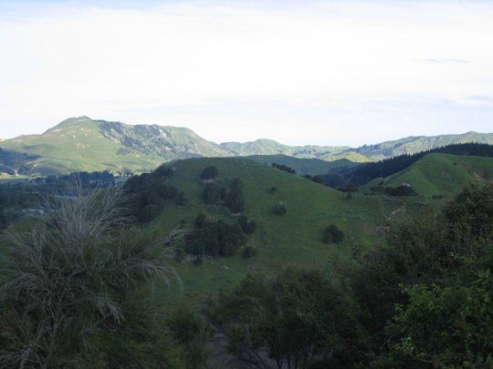
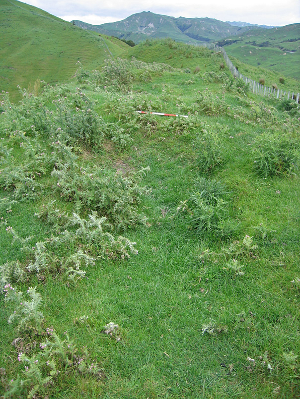
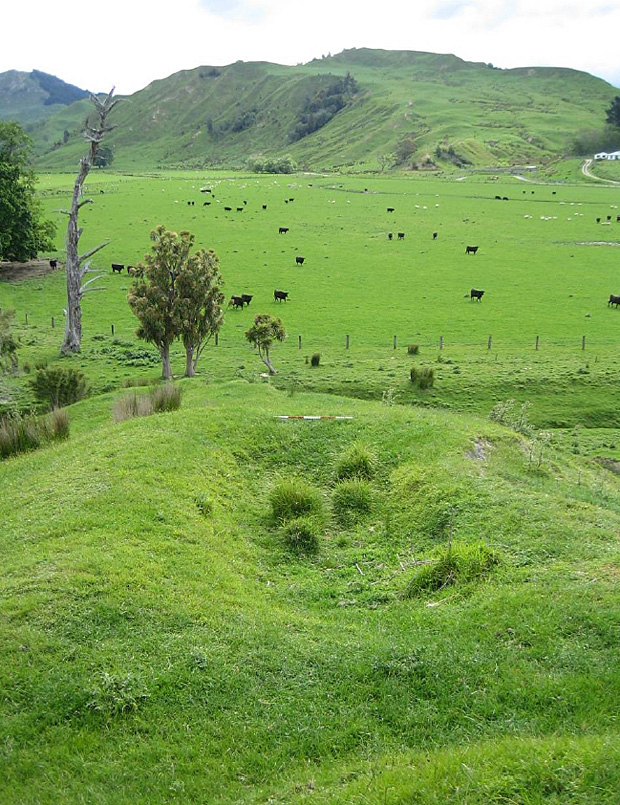
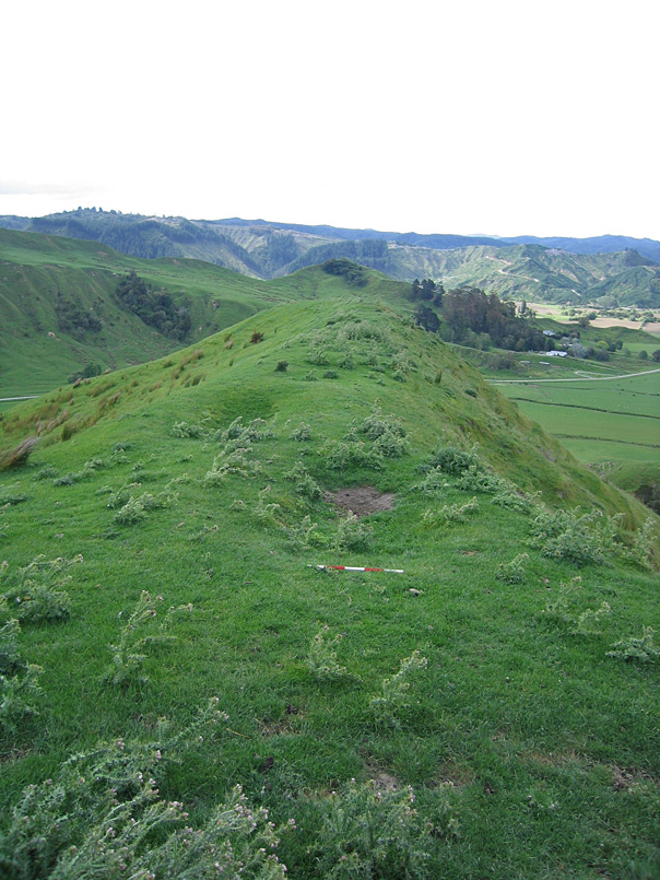
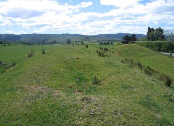
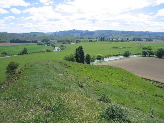
Haparangi is located at the level eastern end of Haparangi hill, overlooking the Uawa River and Waimanu Stream, and with strategic views to the settlement of Tolaga Bay to the east, and Titirangi hill to the southeast. It is currently in pasture, with dense thistle coverage in some areas, and can be accessed via the farm track that runs along the ridgeline. Haparangi is a small pa, occupying approximately 50 metres of ridgeline, and it has been estimated that it could have supported a population of approximately 14 individuals.

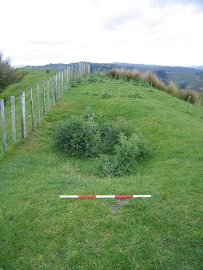
Haparangi was first recorded by the Gisborne Museum in 1971, and was described as a 'terraced hill top pa'. A site plan was completed showing three distinct terraces in a row along the northern part of the site, and two pits (one large, one small) at the western end of the pa. The only artificial defence recorded was a small terrace on the southern edge of the ridge, but the lack of any further artificial defences such as a ditch and bank is not uncommon for pa in the East Coast region; a number of pa are defined by groupings of pits and terraces in naturally defended locations such as this.

Haparangi was revisited by archaeologist Kevin Jones in 1982, presumably during his archaeological survey work in the Whangara, Tolaga Bay and Uawa Catchment areas in 1982-1983. This survey work was undertaken to gain information about the nature of prehistoric settlement in this locality, and also to evaluate specific sites for registration under the Historic Places Act 1980. Jones completed a new sketch plan of the site, indicating that the ridge top consisted of two large terraces, with the shallow depressions recorded by the Gisborne Museum depicted as 'eroded pits?' He also recorded an additional terrace along the southern edge of the site.

In 2000, Haparangi was revisited by archaeologist Vanessa Tanner as part of the New Zealand Archaeological Association Site Recording Scheme Upgrade Project. The pa was covered in two metre high weeds at the time of the visit, but was still in good condition. A further site visit was undertaken in November 2007 by the New Zealand Historic Places Trust, by which time the gorse had been eradicated from the site. The gorse clearance may have caused some damage to the pa, and thistles had started to grow in places, but archaeological features such as the large pit at the western end were clearly visible.

Haparangi is one of several archaeological sites on the western bank of the Uawa River, near its confluence with the Waimanu Stream, which are of cultural, traditional and spiritual significance to Te Aitanga a Hauiti, and have been registered as a wahi tapu area. Haparangi also forms part of a much wider archaeological and cultural landscape that reflects the intensive Maori occupation and settlement of the Tolaga Bay area since the 14th - 15th centuries AD.
Haparangi. Close up of thistle-filled pit looking southwest - Z17/4 | Joanna Wylie | 15/11/2007 | Heritage New Zealand
Haparangi. Looking approximately south to Haparangi from Taharangi - Z17/3 | Joanna Wylie | 15/11/2007 | Heritage New Zealand
Haparangi. Archaeological Site Land Title Form | Heritage New Zealand

List Entry Information

Overview

Status
Listed

List Entry Status
Historic Place Category 2

Access
Private/No Public Access

List Number
6627

Date Entered
10th March 1986

Date of Effect
10th March 1986

City/District Council
Gisborne District

Region
Gisborne Region

Extent of List Entry

Registration includes part of the land described as Pt Paremata 3A Block, Gisborne Land District and the pa known as Haparangi (New Zealand Archaeological Association Site Record Number Z17/4) thereon.

Legal description

Pt Paremata 3A Block (RT GS1C/1268), Gisborne Land District

Detailed List Entry
Reference

Public NZAA Number

Z17/4

Completion Date

8th March 2008

Report Written By

Joanna Wylie

Information Sources

Department of Conservation

Department of Conservation

New Zealand Historic Places Trust (NZHPT)

New Zealand Historic Places Trust

New Zealand Journal of Archaeology

New Zealand Journal of Archaeology

New Zealand Archaeological Association (NZAA)

New Zealand Archaeological Association

Report Written By

This place was identified as significant under previous legislation with different information requirements. It remains significant under the current legislation. There is opportunity under our legislation and policies to add to this information. Further information about this place may be available from the Lower Northern Office of Heritage New Zealand Pouhere Taonga. Iwi/ Hapu/ Whanau: Te Aitanga a Hauti A fully referenced upgrade report is available from the NZHPT Lower Northern Area Office Please note that entry on the New Zealand Heritage List/Rarangi Korero identifies only the heritage values of the property concerned, and should not be construed as advice on the state of the property, or as a comment of its soundness or safety, including in regard to earthquake risk, safety in the event of fire, or insanitary conditions.

Further Information

Current Usages

Uses: Agriculture

Specific Usage: Farm

Former Usages

General Usage:: Maori

Specific Usage: Pā

Themes

Of Significance to Maori

Web Links

Overview

Status

Listed

List Entry Status

Historic Place Category 2

Access

Private/No Public Access

List Number

6627

Date Entered

10th March 1986

Date of Effect

10th March 1986

City/District Council

Gisborne District

Region

Gisborne Region

Extent of List Entry

Registration includes part of the land described as Pt Paremata 3A Block, Gisborne Land District and the pa known as Haparangi (New Zealand Archaeological Association Site Record Number Z17/4) thereon.

Legal description

Pt Paremata 3A Block (RT GS1C/1268), Gisborne Land District

Reference

Historical and Associated Iwi / Hapū / Whānau

Public NZAA Number

Z17/4

Completion Date

8th March 2008

Report Written By

Joanna Wylie

Information Sources

Department of Conservation

Department of Conservation

New Zealand Historic Places Trust (NZHPT)

New Zealand Historic Places Trust

New Zealand Journal of Archaeology

New Zealand Journal of Archaeology

New Zealand Archaeological Association (NZAA)

New Zealand Archaeological Association

Other Information

This place was identified as significant under previous legislation with different information requirements. It remains significant under the current legislation. There is opportunity under our legislation and policies to add to this information. Further information about this place may be available from the Lower Northern Office of Heritage New Zealand Pouhere Taonga. Iwi/ Hapu/ Whanau: Te Aitanga a Hauti A fully referenced upgrade report is available from the NZHPT Lower Northern Area Office Please note that entry on the New Zealand Heritage List/Rarangi Korero identifies only the heritage values of the property concerned, and should not be construed as advice on the state of the property, or as a comment of its soundness or safety, including in regard to earthquake risk, safety in the event of fire, or insanitary conditions.

Further Information

Current Usages

Uses: Agriculture

Specific Usage: Farm

Former Usages

General Usage: Maori

Specific Usage: Pā

Themes

Of Significance to Maori

Current Usages

Uses: Agriculture

Specific Usage: Farm

Former Usages

General Usage: Maori

Specific Usage: Pā

Themes

Of Significance to Maori

Location

Loading
Related listings
Pits/ Terraces. Close-up of single raised rim pit on ridge above Patiki Stream looking west
Pits/ Terraces
Pits. Overview of the site looking approximately north with Mangeheia Road in the background
Pits
Pits
Pits
Pits
Pits
Taharangi and Haparangi
Pits. Close-up of pit on northern side of fence line looking west
Pits
Pits. Looking south over pits at the northern end of the site
Pits
Taharangi
Taharangi
Hikatu
Hikatu
Pits
Pits
Pits. Close-up of pit on northern side of fence line looking west
Pits
Pits/ Terraces. Close-up of single raised rim pit on ridge above Patiki Stream looking west
Pits/ Terraces
Pits. Looking south over pits at the northern end of the site
Pits
Pits. Overview of the site looking approximately north with Mangeheia Road in the background
Pits
Taharangi
Taharangi
Pits
Pits
Hikatu
Hikatu
Pits
Pits
Pits
Pits
Taharangi and Haparangi
Stay up to date with Heritage this month